Sunday, January 20, 2019

The Last Wild River in China

                                                                              by Jim Goodman

the Nu River in upper Gongshan County
       Even in Yunnan, a province famous for its different landscapes, biodiversity and ethnic variety, Nujiang, its westernmost prefecture, stands out as something special.  Three of its four counties straddle the Nu River, one of East Asia's mightiest, 2020 km long from the Tibet-Qinghai border to the Gulf of Martaban (a.k.a. Moktaba) in Myanmar.  And throughout the river's 315 km-long run in Nujiang Prefecture towering mountains flank it on both sides. It is the longest stretch of sustained great scenery in the entire province, looking ever better the further north you go or the higher you climb up the slopes on either bank.
Liuku, Nujiang Prefecture administrative capital
       The Chinese have dubbed Nujiang theGrand Canyon of the East, in conscious reference to the Grand Canyon in southwestern United States.  The latter, though, is very different.  The Colorado River cuts through a flat tableland, with mountains far away, and its main feature is the stunning and picturesque erosion of the canyon wall.  It is also uninhabited.
       In the Grand Canyon of the East, by contrast, mountains flank the river, sometimes rising near vertically from the banks.  Villages and their farms mottle the slopes, in between forests that swathe two-thirds of them.  The people are mostly of the Lisu minority nationality, with smaller numbers of Nu and TIbetan in the north, Yi and Bai communities in the south and Han in the cities.
the Nu River near Chenggan
waterfall just south of Fugong
       The river runs at an average altitude of 800-900 meters.  The mountains, the Biluoshan range east of the river and the Gaoligongshan range to the west, rise an average 4000 meters on either side. The forests vary with the altitude.  Nearer the river grow bamboo, teak, kapok, fig, banyan and tung, an oil-bearing species.  From 1600-2800 meters are bald pine, cypress, yew, chestnut, leach, walnut, magnolia, camellia and Yunnan cherry. Up to 4000 meters, the dominant species are fir, rhododendron, hemlock, dragon spruce, Yunnan pine and dwarf bamboo.
riverside rice fields in summer
       The forests also contain all eight of Yunnan’s famous flowers (azalea, camellia, rough gentian, primrose, orchid, lily, magnolia and meconopsis) and 6000 species of plants, including 370 recognized medicinal plants.  Around 1600 species of insects peculiar to Nujiang live in the canyon, as well as 280 kinds of birds and 70 different mammals. 
       The name of the river is taken from the name of the indigenous Nu nationality in the northern part of the canyon.  (The Lisu didn’t move in until the 17th century.)  In their language nu means dark; hence, the dark people and the dark river.  In Tibet, the Nu River is Heishui (Black River).  But for nu, the Chinese use the ideograph for ‘angry’, which certainly doesn’t characterize the temperament of the people.  But it does seem appropriate for the river. 
plowing a field next to the river
      Rapids make up much of the river’s course.  Its rate of flow can be up to seven meters per second, slightly increased in the summer from rain-fed tributary streams.  In spite of carrying this extra volume of water, the Nu River never floods.  It is safe to plant crops on land just a few meters above the water.
    
It does change color with the rains, becoming a dull medium brown.  When the rains cease and good weather prevails again, the river turns blue-green.  The water level is lower and at some points, especially in Gongshan County, patches of white sand appear along the banks.  In between the long stretches of rapids, where the river runs relatively smoothly, people use rafts or canoes to cross to the other side or to cast fishnets.  They also fish from the shore with poles or use a net stretched between two curved bamboo rods.
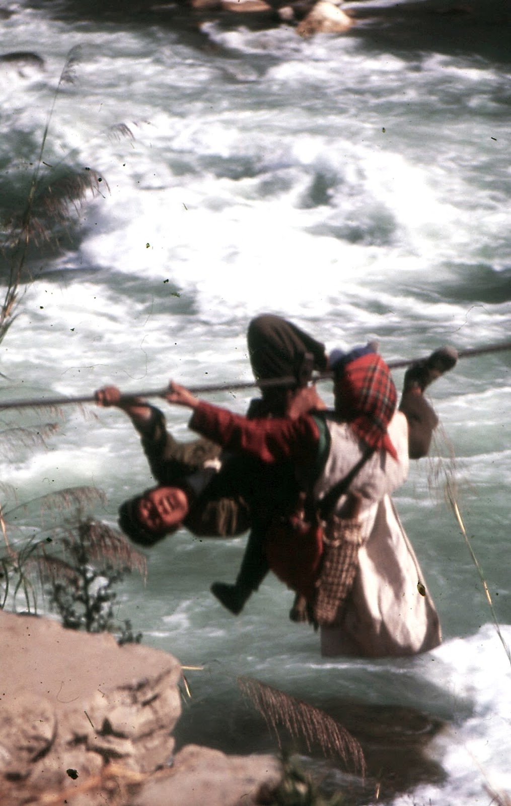
crossing the river by rope-bridge
fishing from the bank, Nujiang-style
     Nujiang was one of the last places modernized in Yunnan.  Not until the 1950s did the government begin constructing a good road from Liuku to Bingzhongluo to replace the caravan trails.  They also built suspension bridges to cross the river, replacing the previous rope-bridges, though in 2000 about two dozen rope-bridges were still in place.  By the turn of the century electricity had been extended to the highest villages. People’s lives had marginally improved, but a large portion was still mired in poverty.
Fugong city
       In 1999 the government banned logging throughout the province.  This was Nujiang’s biggest earner and in attempting to replace it, the local government the following year proposed a hydropower development project involving the building of 13 dams at various points on the river, including a 300-meter-plus behemoth at Maji, and two large reservoirs.  This would result in a power generation of 21 million kilowatts, 3 million more than the one at the Three Gorges in Sichuan, which would be exported to southeast China.      
       The proposal also claimed that as a result of switching to cleaner hydropower the nation could use some of the profits from the dams project to spend on environmental protection.  That point provoked opponents of the dams to launch a campaign against the project.  They wanted to extend the idea of environmental protection to the whole canyon, citing its ecological diversity. Though it comprised but 0.4% of the country’s total area, the canyon was home to over 20% of China’s plants and flowers and 25% of the earth’s animal species (over half of China’s).
rafts used on the river
      The dams would also kill off Nuiang’s 48 species of fish, 36 of them unique to this part of the river, by preventing them from spawning upstream.  Changes in the river’s current would lead to greater contamination, while the putrefying flooded plants would cause a greater emission of greenhouse gases than coal-fired industrial plants. Besides the ecological destruction, the dams would displace 10% of the valley’s half million residents, including the entire population of Gongshan city, saddling the government with the messy problems of resettlement and compensation.
      Though the central government approved the project in the summer of 2003, eco-activists and other opponents kept up their campaign.  By the end of the year they had persuaded Premier Wen Jibao, who called a ‘temporary’ halt to the project.  It was not part of the next five-year plan, nor any since.  In China, the Nu River still runs free.
on the trail to Lumadeng
Gaoligong Mountains at Lumadeng
      It’s possible to explore the Nujiang canyon starting in the far north.  But that involves trekking from Cizhong, on the Lancangjiang, and over the Biluo Mountains to Dimaluo in Gongshan County and then down to the road along the river.  The usual way in is from southwestern Dali Prefecture to Liuku in the south, from where a good road now runs all the way to Qiunatong at the top of the canyon.
suspension bridge below the Stone Moon
      The road into Liuku follows a stream until its confluence with the Nu River.  Liuku, Nujiang’s largest city and administrative capital, straddles the river at the confluence and mountains of 2500-3000 meters flank the river north and south of the city.  Turning south at Liuku, the road continues along the river through the same kind of landscape until Shangjiang.  Then it passes into Baoshan Prefecture, where the mountains are suddenly further away and the river’s current less hurried.
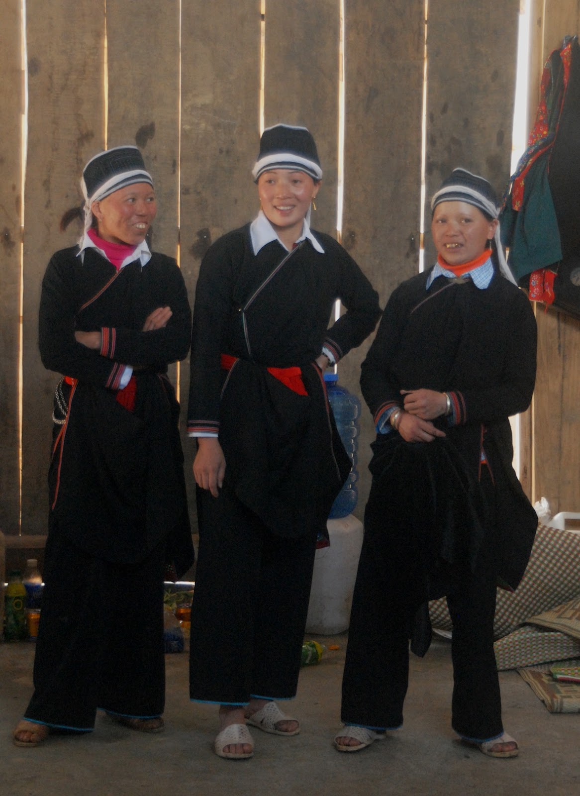
      Though it’s the capital of a Lisu Autonomous Prefecture, Liuku doesn’t have much of an ethnic flavor.  Minorities here and in nearby villages dress in modern styles.  The city has a scenic location, with good views from the bridges and the riverside park on the eastern bank.  As for social scenes, the most interesting takes place at the eastern gate of one of the pedestrian suspension bridges, where a few White Lisu women gather towards evening to sell rice liquor and sing old Lisu songs.
the Nu River near Lishadi
      The road north through Lushui County keeps to the west bank.  Gradually the mountains rise higher, steeper and closer to the river, though still without any snow at their peaks.  At Chenggan, in northern Lushui County, cliffs plunge vertically at the river’s edge.  Continuing north, the road crosses a bridge to the eastern bank just as it passes into Fugong County.  It will stay on this bank all the way to Gongshan city.
       From Pihe, sited opposite a steep sheer cliff and the first town inside the county, the scenery keeps improving.  Mountains are higher, steeper, closer and craggier.  Waterfalls plunge from the sides more frequently.  Terraced fields rise higher on the slopes and several rope-bridges are installed along the river.  Most of residential Fugong city, the county capital, lies on a slope adjacent to the narrow strip of land beside the river. 
Maji village, northern Fugong County
      A few mountains in the vicinity crest at over 4000 meters, permanently mantled with snow. The city has the canyon’s biggest and liveliest market day, held every five days, with the greatest variety of products on sale. Most of the Lisu women from nearby villages wear their traditional clothing while in the city, especially market day.  Crossing the bridge to the west bank leads to a path south to villages and their farms beside the river, a walk especially rewarding during planting time or the early autumn harvest.
      Continuing north, the Gaoligongshan mountains creep closer to the river.  To attend Lumadeng’s Wednesday market day, villagers on that side have to make a long descent and then walk on a narrow path on a steep slope just above the roaring river rapids.  Or they could come down north of the town and use one of the rope-bridges to get to the road into Lumadeng. 
Gongshan city
      Between here and Lishadi, the next town north, stands Nujiang’s most famous mountain—the Stone Moon.  Though not one of the highest Gaoligongshan peaks, it is unique for its huge oval hole, 80 meters wide, just beneath one of the peaks. On the approach to the Stone Moon the road climbs higher than usual above the river, thus affording a great view of the phenomenon from a point above the gorge just south of it. Further on, around Lishadi, too, the mountains take on attractive shapes, with fluted cliffs near the summits.  One right beside the road is peaked like a perfect isosceles triangle.
      Continuing north, the road follows the river past the same kind of mountain scenery into Gongshan County.  Here mountains of 4000-meter peaks are more common, their slopes more forested.  The main road crosses the river before entering Gongshan city and then continues on the west bank of the Nu all the way to Tibet.  For the most part it stays just above the river, but nearing Bingzhongluo is rises a couple hundred meters above the river level, thus affording a wonderful view of the First Turn of the Nu River.
First Turn of the Nu River
      Here the Nu River swirls very dramatically around the ’toes of Biluoshan’—two protrusions of land at the bottom of steep cliffs, each one hosting a village.  Bingzhongluo, on a high plateau above the river, is just around the corner.  From this town Kawagapo Mountain, 5173 meters high, is visible.  Most of the villages in northern Gongshan County are of the Nu ethnic minority, but there a few Lisu and Tibetan settlements as well as Dulong on the other side of Gaoligongshan.
      Going upstream, the new road passes through the Stone Gate, a pair of sheer vertical cliffs flanking the river.  Road engineers had to blast a tunnel through the cliff on the western bank to clear passage for the road.  Continuing north, just short of Qiunatong, a sheer cliff on the eastern bank features a long tunnel through it to allow for local and caravan traffic connecting Qiunatong and the Biluoshan side villages.
the southern 'toe' of Biluoshan
      Travelers cross a suspension bridge to enter Qiunatong.  A mixed Christian Nu and Tibetan village, this is the last major settlement in Nujiang Prefecture.  The boundary of Tibet Province is just a little further.  But across the boundary the landscape changes abruptly, as it did south of Shangjiang.  The mountains are still high, but lie further away from the river, with very little forest cover. 
      The termination of the dams project did not halt development in Nujiang.  The government has continued to renovate and improve the main highway, extend it north into Tibet, construct roads up the slopes of the more densely inhabited mountains and build more suspension bridges spanning the river, designed for motor vehicle traffic as well as pedestrian. 
      With more tourists coming to Nujiang, the canyon now has more hotels and restaurants, the inevitable minority song-and-dance shows and even an established spot just beyond Lumadeng where visitors can experience riding a rope-bridge.  In northern Gongshan County near Shuangla, a pair of Nu villages, Christian on the east bank, Protestant on the west bank, a toll gate in place for over a decade charges non-locals a fee to enter Bingzhongluo Scenic Area.
Stone Gate cliff on the western bank
the river on the way to Qiunatong
      These additions may slightly augment Nujiang’s tourism income, but do not alter what is really the main attraction of the canyon—its pristine natural scenery.  Residents may eventually cease wearing their ethnic garments and suspension bridges may one day replace the last of the rope-bridges.  But the mountains, waterfalls, tributary streams, flora and fauna of the last wild river in China will continue to enchant visitors for many generations to come.

the Stone Moon, Fugong County
                                                                               * * *      

Monday, January 7, 2019

Motorcycling Around Bắc Hà


                                   by Jim Goodman

Hmông women tending a stall in the Sín Chéng market
       At the turn of this century, when foreigners sought to explore the mountain scenery and ethnic variety of northern Vietnam, they went to Sapa.  With a full view of Phansipan, at 3143 meters Vietnam’s highest mountain, lots of Hmông and Dao minorities in town, especially Saturday market day, Sapa had already been popular since it was opened to tourists in the late 80s.  They could take treks around the area and stay in minority villages or climb up to the peak of Phansipan. 
       About the only excursion out of the district visitors might take was a trip to Bc Hà, about 100 km away on the other side of the Red River, for the Sunday market.  They arrived in late morning, when the town was full of Flowery Hmông, who dressed very differently from the Black Hmông around Sapa, and left mid-afternoon when the market action was receding.  Hardly anyone stayed the night there, or visited during the week.
hill scenery near Lùng Phìn
       As the years rolled on Sapa became very congested with tourists, foreign and domestic, who became subject to increasing commercial pressure from minority women and girls selling handicrafts.  Travelers then began paying more attention to Bắc Hà.  The town lay in a broad valley surrounded by hills, a picturesque setting even if not as dramatic as Sapa’s.  In 2006 the renovated colonial era palace re-opened and so the town now had an historical attraction.  Instead of a quick Sunday afternoon visit, people now stayed a night or two.
       In recent years, though, for the Sunday market day, often more foreigners are present than local people.  And a portion of the local Hmông have become like the minority merchants on the streets of Sapa, constantly importuning foreigners to buy something from them.  Bắc Hà’s hotels are full on weekends and home-stay options have cropped up all over the suburbs.  During the week the town is much quieter, yet that is a more interesting time to visit, for towns across the district have their own market days, where foreign visitors are too few to notice and no one pesters them to buy anything.
Hmông child in Sín Chéng
Hmông girl's ornamented turban
       With this in mind, my friend and I planned on exploring the district during the week and departing Sunday morning.  Arriving on a Tuesday evening, we rented motorbikes and set out early next morning for Sín Chéng’s market day, in the northwest part of Bắc Hà district.  The road ran north about 30 km to Simacai through lovely hills with terraced slopes and scattered villages.  From here we turned southwest, passing views of yet more terraced hills with even higher mountains as a backdrop.
       A small, narrow town, Sín Chéng lies on a high ridge.  For this Wednesday market stalls filled the lanes around its central intersection.  Just down the slope below them were the noodle shops and covered market lanes, mostly selling Hmông clothing.  In the field beside them was the livestock market.
Thu Lao woman in Sín Chéng
Tày women in Bản Liền
       About 90% of the people in Sín Chéng that day were Hmông, almost all women and all dressed in Hmông style.  This could vary, though.  Some wore the long bulky traditional Flowery Hmông skirt that was once the norm throughout the district.  On top they wore side-fastened jackets with thick bands of appliqué around the cuffs, sleeves and neckline.  Most women, of all ages, wore factory-produced skirts, knee-length, pleated and printed with innumerable kinds of patterns, some copying Hmông designs, some not. 
Bàn Liền market day
       The contemporary Flowery Hmông female outfit is not so uniform-like as before.  With the traditional look, the jacket’s background color would vary, but the bands of appliqué were always in the same places and in the same style, while the long and heavy skirt was covered with wide horizontal bands of appliqué with similar motifs. 
       Nowadays no two skirts are alike, just shaped the same and the jacket variety is enormous, especially among the young women.  They also go in more for sparkling decorations on the clothes and turbans, like filigreed silver, pendants, rings and discs.  It all looks very modern, but is still Hmông style.  No other minority women would dress like that.
waterfall near Tà Cù Tỳ
sign of a ritual location
       Besides the Hmông, those in the Sín Chéng market included some Giấy and Thu Lao women, Vietnamese and six other foreigners, who like us were pretty much ignored.  The Giấy wore ordinary, side-fastened jackets in pastel colors, over plain black trousers.  The Thu Lao, a branch of the Tày, wore a collarless, long-sleeved jacket over an ankle-length skirt, all black except for colored bands around the sleeve cuffs.  They also wore a tall black turban with a small white tab protruding over the right eyebrow.
Black Dao ritual dance performers
       The market began closing down around one p.m., so after lunch we headed back going south through western Bấc Hà district.  The hills were never too steep for our motorbikes, the scenery excellent, accented by a small waterfall along the way.  We re-entered Bắc Hà town via the large Hmông village of Bản Phố above it.  The road down to town was lined with cherry trees in full blossom, with occasional fields of plum trees, also flowering, to the sides.  This was our longest ride of the week, but quite satisfactory. 
       Market day Thursday was at Bản Liền, a Tày village to the east, less than an hour’s ride through similar attractive scenery.  Tày hamlets start appearing after about halfway, characterized by stilted houses with thatched or tiled roofs standing right among the terraces.  Bản Liền’s market day is a very localized one that starts early.  Other than a handful of Hmông, everyone there was Tày, except us, plus a Frenchman and his Vietnamese guide.
writhing on the floor for the final dance
       Tày women wore knee-length, side-fastened black coats over black trousers.  The only color embellishment was a bright sash belt and a little trimming on the lapel, cuffs or hems.  They carried brightly embroidered shoulder bags, though, often featuring a triple fan motif.  The one baby we saw, carried by a Tày man, wore an embroidered cap with coins along the brim.  The market began shutting down around 10:30, a time for four Tày men to call me over to drink rice liquor with them.  I acquiesced and downed one shot with each of them, explained that was enough because I had to drive, and they didn’t persist, thanked me, shook my hand and wished me well.
       Our next destination was Tả Củ Tỷ, a Dao village (pronounced Zao) 30 km north.  The road passed by more Tày hamlets and stilted houses.  Then, a few km before Tả Củ Tỷ, the road dipped a little and passed by a waterfall.  Different from the long thin cataracts of the one we saw the day before, this one was shorter, swerved around a boulder in its path and plunged into the pool beside the road.  Tả Củ Tỷ was just around the bend and up the slope, the houses sitting on the ground and not stilted.
Dao shaman with scriptures and drum
young Dao women, Tà Cù Tỳ
       Tả Củ Tỷ’s residents are from the Black Dao sub-group, so named for the dominant color of their clothing.  Both men and women wear plain black, side-fastened, long-sleeved jackets over black trousers.  Women might add a thin band of blue or red on the jacket lapel, side hems and cuffs and white bands around the headscarf.  Men don a wide black turban.
mountain view in northern Bắc hà district
       In the yard of one of the first houses we passed stood a pair of crossed poles with streamers hanging down from various points.  This was a sign of some sort of ritual going on inside.  Those standing outside at once waved to us to stop and come inside.  The event was the second day of the three-day initiation rite for a young man into full adulthood.  And by a wonderful coincidence, we were just in time for the start of the ritual dances.  The host asked us each to contribute 20,000 đồng (about $1) to a tray full of money, presumably for expenses and the food afterwards.
       The room was decorated with flags, banners, paintings and paper cutout streamers, while several men made up the troupe.  Four of them wore long red robes and two of this group had pictures of Taoist deities affixed to their turbans.  The others wore a mixture of Dao and modern clothes.  Beside them sat the shaman, reading from a scriptural book and beating a drum.
traditional Hmông style in Cán Cấu
modern Hmông fashions in the Cán Cấu market
       The dances were slow in the beginning, mainly walking in a circle or standing and gesticulating.  Then the tempo increased and included hopping and knee bending.  For the finale, several of the men rolled wildly on the floor.  The show lasted about an hour, followed by a big feast and lots of rice liquor.  Before we left, our hosts invited us to return in the morning for the final rituals, though no one could tell us what time.
       We arrived at 8:00 next morning, but the main ritual, whatever it was, had finished.  All that remained was a shaman inside the door, reciting prayers while seated beside a round bamboo table full of ritual paraphernalia.  Everywhere else inside people were loading dishes onto long tables for the big feast and we were naturally invited to partake.
Flowery Hmông in the Cán Cấu market
       The repast was even more sumptuous than the one the day before, comprising several different preparations of pork and chicken, some vegetables, soup and lots of rice liquor.  Men and women ate at the same tables and the women, young and old, also indulged in the liquor.  Only after our leisurely meal did we learn Friday was Tả Củ Tỷ’s market day.  But we were too late already.  Like at Bản Liền, it finished early.  After a ride to a few scenic spots on the way west to Lùng Phìn, we turned south, took a longer pause among the cherry blossoms above Bấc Hà, and returned to our hotel.
       Our Saturday program was to head north to market day in Cán Cấu.  Since this town is on the way to Simacai, we rode across the same scenery as the other days.  So we decide to take the turnoff above Lùng Phìn to Cán Cấu Lake.  The road was cut into a very steep ridge for about five km to where we could view the lake below, small and placid, backed by high wooded mountains.
       We didn’t feel like hiking down to the shoreline and then back up again, especially since the morning fog hadn’t lifted completely.  But as we drove past the viewpoint the road suddenly began descending along a serpentine route to the valley far below.  After that the road turned east towards Cán Cấu, following a stream.  It was certainly a beautiful back way in to the town, but too strenuous to return the same way so we resolved to go back to Bắc Hà via the main road we were familiar with.
trying on a new Hmông outfit
little Hmông girl at Cán Cấu
       Cán Cấu lies further along this stream, a little bigger town than those we’d stopped in so far.  The market area lay beyond the town, with parking areas in front, behind and on one side.  The area was bigger than Sín Chéng’s market and, like the latter, had a livestock market, all buffaloes in this case, on the slope behind the covered stalls.
       The biggest difference between Cán Cấu and the other places we’d visited was the presence of foreigners.  The parking lot at the far end held several minibuses for foreigners who’d come from Sapa or Lào Cai on their way to Bắc Hà, where they would spend the night and observe the Sunday morning market scene.  Cán Cấu was supposed to be their preview and in general the groups only stayed for about an hour.
winter cherry blossoms on the road above Bấc Hà 
       Actually, it more resembled Bắc Hà’s market back in 2000.  The tourists did not interact with the Hmông, nor penetrate very far into the market grounds.  The Hmông were polite and friendly to those who did engage with them or buy something.  But except for a handful of Bắc Hà Hmông, who came with bags of trinkets and followed the groups around, the local Hmông ignored the foreigners.
       Stalls along the road offered vegetables, spices, herbs, bamboo items and other necessities.  Hmông people comprised the sellers and the buyers.  All the women dressed Hmông style, like at Sín Chéng, where a few wore the traditional bulky long skirt, while most favored the factory-made pleated and printed skirts.  Young women and children donned bright and flashy outfits accented by lots of silver jewelry and even the smallest wore silver ornaments and fancy headgear.  The many rows of stalls selling modern Hmông clothing were the busiest of the day.
       Cán Cấu’s market wound down mid-afternoon, long after the last tourist buses had departed.  With so much color and beauty constantly passing before our eyes, we stayed late to enjoy it all longer.  On our ride back to Bắc Hà, the late afternoon sun bathed the hills with a golden hue and illuminated for us once more the plum and cherry blossoms on the way.  It was a fitting conclusion to four days of fun and fascination.

Dao feast after the rituals atTảCủ Tỷ 

                                                                                 * * *    

                     Delta Tours Vietnam offers excursions to mountain destinations like Bắc Hà,                                            See https://www.deltatoursvietnam.com/other-tour-options