Showing posts with label Biluoshan. Show all posts

Sunday, January 20, 2019

The Last Wild River in China

                                                                              by Jim Goodman

the Nu River in upper Gongshan County
       Even in Yunnan, a province famous for its different landscapes, biodiversity and ethnic variety, Nujiang, its westernmost prefecture, stands out as something special.  Three of its four counties straddle the Nu River, one of East Asia's mightiest, 2020 km long from the Tibet-Qinghai border to the Gulf of Martaban (a.k.a. Moktaba) in Myanmar.  And throughout the river's 315 km-long run in Nujiang Prefecture towering mountains flank it on both sides. It is the longest stretch of sustained great scenery in the entire province, looking ever better the further north you go or the higher you climb up the slopes on either bank.
Liuku, Nujiang Prefecture administrative capital
       The Chinese have dubbed Nujiang theGrand Canyon of the East, in conscious reference to the Grand Canyon in southwestern United States.  The latter, though, is very different.  The Colorado River cuts through a flat tableland, with mountains far away, and its main feature is the stunning and picturesque erosion of the canyon wall.  It is also uninhabited.
       In the Grand Canyon of the East, by contrast, mountains flank the river, sometimes rising near vertically from the banks.  Villages and their farms mottle the slopes, in between forests that swathe two-thirds of them.  The people are mostly of the Lisu minority nationality, with smaller numbers of Nu and TIbetan in the north, Yi and Bai communities in the south and Han in the cities.
the Nu River near Chenggan
waterfall just south of Fugong
       The river runs at an average altitude of 800-900 meters.  The mountains, the Biluoshan range east of the river and the Gaoligongshan range to the west, rise an average 4000 meters on either side. The forests vary with the altitude.  Nearer the river grow bamboo, teak, kapok, fig, banyan and tung, an oil-bearing species.  From 1600-2800 meters are bald pine, cypress, yew, chestnut, leach, walnut, magnolia, camellia and Yunnan cherry. Up to 4000 meters, the dominant species are fir, rhododendron, hemlock, dragon spruce, Yunnan pine and dwarf bamboo.
riverside rice fields in summer
       The forests also contain all eight of Yunnan’s famous flowers (azalea, camellia, rough gentian, primrose, orchid, lily, magnolia and meconopsis) and 6000 species of plants, including 370 recognized medicinal plants.  Around 1600 species of insects peculiar to Nujiang live in the canyon, as well as 280 kinds of birds and 70 different mammals. 
       The name of the river is taken from the name of the indigenous Nu nationality in the northern part of the canyon.  (The Lisu didn’t move in until the 17th century.)  In their language nu means dark; hence, the dark people and the dark river.  In Tibet, the Nu River is Heishui (Black River).  But for nu, the Chinese use the ideograph for ‘angry’, which certainly doesn’t characterize the temperament of the people.  But it does seem appropriate for the river. 
plowing a field next to the river
      Rapids make up much of the river’s course.  Its rate of flow can be up to seven meters per second, slightly increased in the summer from rain-fed tributary streams.  In spite of carrying this extra volume of water, the Nu River never floods.  It is safe to plant crops on land just a few meters above the water.
    
It does change color with the rains, becoming a dull medium brown.  When the rains cease and good weather prevails again, the river turns blue-green.  The water level is lower and at some points, especially in Gongshan County, patches of white sand appear along the banks.  In between the long stretches of rapids, where the river runs relatively smoothly, people use rafts or canoes to cross to the other side or to cast fishnets.  They also fish from the shore with poles or use a net stretched between two curved bamboo rods.
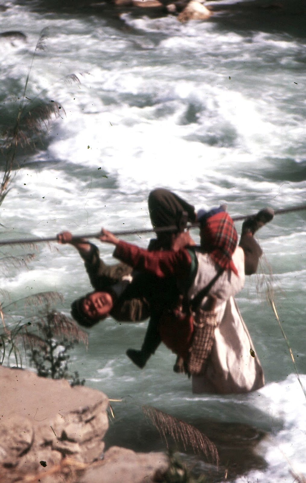
crossing the river by rope-bridge
fishing from the bank, Nujiang-style
     Nujiang was one of the last places modernized in Yunnan.  Not until the 1950s did the government begin constructing a good road from Liuku to Bingzhongluo to replace the caravan trails.  They also built suspension bridges to cross the river, replacing the previous rope-bridges, though in 2000 about two dozen rope-bridges were still in place.  By the turn of the century electricity had been extended to the highest villages. People’s lives had marginally improved, but a large portion was still mired in poverty.
Fugong city
       In 1999 the government banned logging throughout the province.  This was Nujiang’s biggest earner and in attempting to replace it, the local government the following year proposed a hydropower development project involving the building of 13 dams at various points on the river, including a 300-meter-plus behemoth at Maji, and two large reservoirs.  This would result in a power generation of 21 million kilowatts, 3 million more than the one at the Three Gorges in Sichuan, which would be exported to southeast China.      
       The proposal also claimed that as a result of switching to cleaner hydropower the nation could use some of the profits from the dams project to spend on environmental protection.  That point provoked opponents of the dams to launch a campaign against the project.  They wanted to extend the idea of environmental protection to the whole canyon, citing its ecological diversity. Though it comprised but 0.4% of the country’s total area, the canyon was home to over 20% of China’s plants and flowers and 25% of the earth’s animal species (over half of China’s).
rafts used on the river
      The dams would also kill off Nuiang’s 48 species of fish, 36 of them unique to this part of the river, by preventing them from spawning upstream.  Changes in the river’s current would lead to greater contamination, while the putrefying flooded plants would cause a greater emission of greenhouse gases than coal-fired industrial plants. Besides the ecological destruction, the dams would displace 10% of the valley’s half million residents, including the entire population of Gongshan city, saddling the government with the messy problems of resettlement and compensation.
      Though the central government approved the project in the summer of 2003, eco-activists and other opponents kept up their campaign.  By the end of the year they had persuaded Premier Wen Jibao, who called a ‘temporary’ halt to the project.  It was not part of the next five-year plan, nor any since.  In China, the Nu River still runs free.
on the trail to Lumadeng
Gaoligong Mountains at Lumadeng
      It’s possible to explore the Nujiang canyon starting in the far north.  But that involves trekking from Cizhong, on the Lancangjiang, and over the Biluo Mountains to Dimaluo in Gongshan County and then down to the road along the river.  The usual way in is from southwestern Dali Prefecture to Liuku in the south, from where a good road now runs all the way to Qiunatong at the top of the canyon.
suspension bridge below the Stone Moon
      The road into Liuku follows a stream until its confluence with the Nu River.  Liuku, Nujiang’s largest city and administrative capital, straddles the river at the confluence and mountains of 2500-3000 meters flank the river north and south of the city.  Turning south at Liuku, the road continues along the river through the same kind of landscape until Shangjiang.  Then it passes into Baoshan Prefecture, where the mountains are suddenly further away and the river’s current less hurried.
      Though it’s the capital of a Lisu Autonomous Prefecture, Liuku doesn’t have much of an ethnic flavor.  Minorities here and in nearby villages dress in modern styles.  The city has a scenic location, with good views from the bridges and the riverside park on the eastern bank.  As for social scenes, the most interesting takes place at the eastern gate of one of the pedestrian suspension bridges, where a few White Lisu women gather towards evening to sell rice liquor and sing old Lisu songs.
the Nu River near Lishadi
      The road north through Lushui County keeps to the west bank.  Gradually the mountains rise higher, steeper and closer to the river, though still without any snow at their peaks.  At Chenggan, in northern Lushui County, cliffs plunge vertically at the river’s edge.  Continuing north, the road crosses a bridge to the eastern bank just as it passes into Fugong County.  It will stay on this bank all the way to Gongshan city.
       From Pihe, sited opposite a steep sheer cliff and the first town inside the county, the scenery keeps improving.  Mountains are higher, steeper, closer and craggier.  Waterfalls plunge from the sides more frequently.  Terraced fields rise higher on the slopes and several rope-bridges are installed along the river.  Most of residential Fugong city, the county capital, lies on a slope adjacent to the narrow strip of land beside the river. 
Maji village, northern Fugong County
      A few mountains in the vicinity crest at over 4000 meters, permanently mantled with snow. The city has the canyon’s biggest and liveliest market day, held every five days, with the greatest variety of products on sale. Most of the Lisu women from nearby villages wear their traditional clothing while in the city, especially market day.  Crossing the bridge to the west bank leads to a path south to villages and their farms beside the river, a walk especially rewarding during planting time or the early autumn harvest.
      Continuing north, the Gaoligongshan mountains creep closer to the river.  To attend Lumadeng’s Wednesday market day, villagers on that side have to make a long descent and then walk on a narrow path on a steep slope just above the roaring river rapids.  Or they could come down north of the town and use one of the rope-bridges to get to the road into Lumadeng. 
Gongshan city
      Between here and Lishadi, the next town north, stands Nujiang’s most famous mountain—the Stone Moon.  Though not one of the highest Gaoligongshan peaks, it is unique for its huge oval hole, 80 meters wide, just beneath one of the peaks. On the approach to the Stone Moon the road climbs higher than usual above the river, thus affording a great view of the phenomenon from a point above the gorge just south of it. Further on, around Lishadi, too, the mountains take on attractive shapes, with fluted cliffs near the summits.  One right beside the road is peaked like a perfect isosceles triangle.
      Continuing north, the road follows the river past the same kind of mountain scenery into Gongshan County.  Here mountains of 4000-meter peaks are more common, their slopes more forested.  The main road crosses the river before entering Gongshan city and then continues on the west bank of the Nu all the way to Tibet.  For the most part it stays just above the river, but nearing Bingzhongluo is rises a couple hundred meters above the river level, thus affording a wonderful view of the First Turn of the Nu River.
First Turn of the Nu River
      Here the Nu River swirls very dramatically around the ’toes of Biluoshan’—two protrusions of land at the bottom of steep cliffs, each one hosting a village.  Bingzhongluo, on a high plateau above the river, is just around the corner.  From this town Kawagapo Mountain, 5173 meters high, is visible.  Most of the villages in northern Gongshan County are of the Nu ethnic minority, but there a few Lisu and Tibetan settlements as well as Dulong on the other side of Gaoligongshan.
      Going upstream, the new road passes through the Stone Gate, a pair of sheer vertical cliffs flanking the river.  Road engineers had to blast a tunnel through the cliff on the western bank to clear passage for the road.  Continuing north, just short of Qiunatong, a sheer cliff on the eastern bank features a long tunnel through it to allow for local and caravan traffic connecting Qiunatong and the Biluoshan side villages.
the southern 'toe' of Biluoshan
      Travelers cross a suspension bridge to enter Qiunatong.  A mixed Christian Nu and Tibetan village, this is the last major settlement in Nujiang Prefecture.  The boundary of Tibet Province is just a little further.  But across the boundary the landscape changes abruptly, as it did south of Shangjiang.  The mountains are still high, but lie further away from the river, with very little forest cover. 
      The termination of the dams project did not halt development in Nujiang.  The government has continued to renovate and improve the main highway, extend it north into Tibet, construct roads up the slopes of the more densely inhabited mountains and build more suspension bridges spanning the river, designed for motor vehicle traffic as well as pedestrian. 
      With more tourists coming to Nujiang, the canyon now has more hotels and restaurants, the inevitable minority song-and-dance shows and even an established spot just beyond Lumadeng where visitors can experience riding a rope-bridge.  In northern Gongshan County near Shuangla, a pair of Nu villages, Christian on the east bank, Protestant on the west bank, a toll gate in place for over a decade charges non-locals a fee to enter Bingzhongluo Scenic Area.
Stone Gate cliff on the western bank
the river on the way to Qiunatong
      These additions may slightly augment Nujiang’s tourism income, but do not alter what is really the main attraction of the canyon—its pristine natural scenery.  Residents may eventually cease wearing their ethnic garments and suspension bridges may one day replace the last of the rope-bridges.  But the mountains, waterfalls, tributary streams, flora and fauna of the last wild river in China will continue to enchant visitors for many generations to come.

the Stone Moon, Fugong County
                                                                               * * *      

Monday, August 18, 2014

At the Top of the Nujiang Canyon: Life in Bingzhongluo


                                                       by Jim Goodman

the FIrst Turn of the Nu River
     The usual way to enter the Nujiang Canyon in western Yunnan is by road to Liuku, the prefecture capital.  Already the scenery typical of Nujiang is apparent.  High mountains topping 3000 meters flank both sides of the river.  Going north to the top end of the canyon, the mountains just keep getting higher and often stand very close to the river.  By Fugong they are over 4000 meters, peaks swathed in snow and by northern Gongshan County, visible from Bingzhongluo, even crest 5000 meters.  But it’s not only the mountains that make Bingzhongluo an officially designated Scenic Area.  The district is also blessed with some of the best river scenery in the province and home to an ethnic mix of Nu, Lisu and Tibetan communities, attractions that can be savored even when clouds obscure the snow-mantled peaks.
     From Gongshan Bingzhongluo is 43 km north.  The ticket booth for entry is just before Shuangla, about 7 km south.  From here the road rises gradually until it is about two hundred meters above the river, passing what is called the First Turn of the Nu River.  Here the river loops a plot of land backed by high cliffs that forms one of the “toes” of Biluoshan, the mountain range on the eastern side of the river.  The road opposite is an outstanding engineering feat, cut from steep mountain cliffs.  In the beginning of this century it was still a little hazardous drive, subject to sudden landslides, and passengers all had to disembark and walk a kilometer or so around the loop.  But after another kilometer we rounded the cliff and got our first glimpse of both Bingzhongluo and the other “toe” of Biluoshan.
Zanahong village, the other "toe" of Biluoshan
     Like the First Turn village, this one, slightly larger, lay on a spur of land backed by steep cliffs, but also connected to the other side by a suspension bridge.  The village, Zanahong, is Nu, the farms spread out in front of the houses, with walnut groves at the lower end.  It’s about a thirty-minute walk up a gradual slope past Lisu farms from here to the town.  Bingzhongluo lies on a long, plateau-like spur as high above the river as the road at the First Turn.  It’s basically a one-street town, with a couple hotels and a few restaurants, only lively on Tuesday market days.  Never mind the town, though.  The natural beauty of the place just demands exploration.
Bingzhongluo
     To the northwest rises Kawagapu, 5173 meters high, the tallest peak in Nujiang.  The best view of this is from the top of the mountain beside the road entering Bingzhongluo.  A dirt road zigzags up the side, but I used goat path shortcuts to ascend in an hour.  From cabins at the end of the road it’s a short walk to the platform enabling a bird’s-eye view of the First Turn of the Nu River.  Returning to descend affords appreciation of Kawagapu and the Bingzhongluo setting, as well as other snow mountains of well over 4000 meters.
     From Bingzhongluo it’s a two-hour hike north to the Stone Gate, a pair of high boulders with sheer cliffs flanking the riverbanks.  A road was cut through the cliff on the western side, continuing another ten km to Qiunatong, just beyond Wuli, a Nu village on the Biluoshan side.  Cut off by a sheer cliff from Qiunatong, the people centuries ago hollowed out a trail in the cliff through which residents and caravans could pass.
ancient trail to Wuli
     When I first visited the area in the early 2000s caravans were still a part of life in Bingzhongluo, one of the last places in Yunnan, transporting goods from Yunnan to Tibet.  The journey back and forth took 15 days and could include up to forty animals.  A new paved road past Qiunatong opened a few years later, putting a virtual end to that tradition.  Caravans couldn’t compete with trucks.
     Depending on which season, the scenery on the Nu River will vary.  It’s always a swift river, full of rapids, moving at a rate of up to seven meters per second in some places, but the color and volume changes.  In the summer it is brown and full, though it never floods its banks.  In the winter it is blue-green, running at a lower level, sometimes exposing little beach-like slivers of white sand, such as on the “toes” of Biluoshan and villages just south of the First Turn.  Likewise, the land scenery will vary with the seasons.  Autumn features patches of red and gold in the forested hills and spring sees the blooming of umpteen kinds of wildflowers.
the Stone Gate
    The villages adjacent to Bingzhongluo are Lisu, but most settlements in the district are Nu, the aboriginals of the district, who migrated here a thousand years ago from the Lancangjiang Valley (Upper Mekong) over the Biluo Mountains to the east.  They settled near and above the river, built houses of wood with roofs of slate tiles, plowed fields with two bullocks yoked together and used heated stones as one of their cooking methods.  The other major community in the area is Tibetan, particularly in Puhua village, on the tableland just north of Bingzhongluo, across a gorge cut by a stream running past the Nu village of Jiasheng.  
Nu houses and a passing caravan behind them   
     The first Tibetan into the area was a monk of the Karmapa sect from eastern Tibet, whose mission was to convert the animist Nu to the Tibetan brand of Buddhism.  He made Puhua his base and was soon joined by Tibetan settlers.  The move was part of an expansionist campaign by lamas and officials in Diqing and Kangpu, on the Lancangjiang, to extend not only their religion but also political control over frontier areas beyond the direct reach of the Qing government.
     Both conversion and Tibetan immigration were slow but steady.  In 1782 a temple and monastery went up in Puhua, from where Tibetans administered the whole district.  But they were not very kind to the Nu converts, looked down on them as inferiors and forced them to pay land use tax under the claim all the district’s lands that the Nu had been cultivating for centuries actually belonged to the monastery.  Finding life as Buddhists was not improving their lives, the Nu began converting to Christianity when the first French Catholic priests began proselytizing in Gongshan County from the late 19th century.
Nu woman with Nujiang-style pipe 
young Nu woman in traditional style
     Finding the new religion encouraged Nu insubordination, the Puhua lamas organized attacks on the churches in the early 20th century.  This provoked Chinese military intervention, the destruction of the monastery (rebuilt afterwards) and the incorporation of Bingzhongluo district into the provincial administration.  A century later ethnic and religious animosities have long been extinct.  Nu and Tibetan intermarry.  Some Tibetans are now Christian, while some Nu are still Buddhist, including a few of the monks at Puhua.
     When the Tibetans first brought Buddhism to Bingzhongluo, the Nu discovered an interpretation of the world that was far more complex, organized and encompassing than their own simple animist concepts.  As a people who’d been beyond the perimeter of Chinese culture, the Nu also felt the Tibetan religion to be the product of a society more powerful, advanced, sophisticated and prestigious than anything hitherto encountered. 
TIbetan monastery at Puhua
     For the Nu, proof of Tibetan cultural superiority was in the latter’s ability to establish political control over people who greatly outnumbered them.  Besides Buddhism, the Tibetans also had a martial tradition.  The Nu did not.  Tibetans also used better tools and were better farmers, passing on their knowledge to local Nu, which enabled them to increase agricultural production.  Tibetan influence on the Nu persisted even after the Nu adopted Christianity.  Tibetan chortens stand in the fields of Christian Nu villages and strings of Buddhist prayer flags flutter across the canyon next to the Christian Nu village of Jiasheng.  Many Nu women dress in the Tibetan style, with long-sleeved blouses and the colorful, horizontally striped apron.
     The Nu have their own traditional style clothing, featuring a vertically striped wraparound long skirt with a distinctive, subtle arrangement of subdued colors.  Women weave the cloth on a back-strap loom, which can be hooked up to a house post, tree trunk, or even the back of a tractor-trailer.  The cloth is also used for blankets, headscarves, shoulder bags and vests worn by both men and women.
on the trail to A-rong's cave
     The unique colored stripe pattern Nu people attribute to their ancient culture-bearing heroine A-rong.  She created the design after watching a sunset.  The Nu also credit her with inventing the rope-bridge, supposedly because she was enamored by a young man on the other side of the river.  With a giant crossbow she fired a line fixed to an arrow to the other shore, fastened her end to a tree and scampered across.  She also introduced irrigation canals and other agricultural methods and was renowned for both her beauty and her intelligence.
     These qualities aroused the ardor of a local bandit chief who tried repeatedly to woo her.  Meeting constant rebuffs, he then seized her and sealed her in a cave near Bingzhongluo, where she died and turned into stone.  Time passed and eventually the Nu built a shrine to her in this cave and instituted an annual festival in her honor on the 15th day (full moon) of the 3rd lunar month.  Nowadays it is the biggest event of the year in the Bingzhongluo area, celebrated by the Nu from all the district’s villages.  The A-rong story is something every Nu knows, so whether they are Christian, Buddhist, animist or atheist, they will come to her cave-shrine this day because it’s kind of Nu National Day.
Tibetan hostesses welcome devotees
     The Nu call it Xiannujie, Heavenly Maiden Festival, but it is also known as the Festival of Fresh Flowers for the many wildflowers blooming at the time that are also part of the offerings at the shrine.  In its contemporary version the event includes a stage show of Nu, Tibetan, Lisu and Dulong dances in the town and a lively market scene with merchants hawking goods ranging from cheap manufactured items brought up from Gongshan to ethnic minority handicrafts, Tibetan antiques and paraphernalia, fruits, kebabs, snacks, rice spirits and beer.
     The main event, though, is the visit to A-rong’s cave shrine, where the host for the day is not Nu, but the Tibetan village of Puhua.  Devotees begin the one-hour hike there from Bingzhongluo from early morning.  The route bends around and behind Puhua, affording a fine view of that village and Stone Gate rising beyond it. Halfway to the cave, devotees pass through an entrance gate erected by the Puhua hosts, where four beautifully dressed young Tibetan women offer people welcoming cups of refreshment—water first, then rice beer, finally rice spirits.  From there it’s still a long walk to the cave, but the spot is soon visible thanks to the many lines of prayer flags strung from the trees above it.
     Inside the cave flower offerings, especially azaleas, ears of corn, representing the agricultural knowledge A-rong introduced, and votive lamps surround A-rong’s shrine.  Overhead droop two long stalactites said to be A-rong’s breasts.  Water slowly drips off the ends of these and some devotees collect these drops in glass jars, which takes several minutes to fill, and smear it on their heads and faces, drink it or take it home for private ritual use.  Others prostrate before the shrine or circumambulate it a few times and kowtow afterwards.
circumambulating A-rong's shrine
     On a slope below the cave devotees next stop at the tent erected for a group of Puhua lamas conducting prayers with the aid of old books and the occasional addition of flute, drum and viol accompaniment.  One monk offers rice-beer to anyone who comes inside to pray or to listen.  The scene around the cave stays active until late afternoon, for Han and Lisu from further down the canyon, as well as Nu from more distant villages, continue to arrive.           
     Back in Bingzhongluo the returning crowds explore the markets, sample the snacks, watch the dances, get drunk and hop buses going south.  By ten p.m. the shows are over and only the die-hard revelers remain around the few drink and food stalls still operating.  The next day city cleaners dismantle the stage and sweep the streets.  The Nu put away their ethnic clothing until the next excuse.  Color and excitement concluded, the town reverts to its usual level of minimal activity and all that’s left to enjoy on a normal day again in Bingzhongluo is, well, the utterly magnificent scenery.   
young Nu woman collects water from the"breast" of A-rong
                                                                 * * *