Sunday, November 27, 2016

Wandering Around Weixi County


                                              by Jim Goodman

Tacheng TIbetan neighborhood
       Anyone wishing to meet or research Tibetans in Yunnan goes to Diqing Tibetan Autonomous Prefecture in the northwest.  Tibetan villages lie all over the high plateau and rolling hills of Shangrila County and speckle the steep hills of the more rugged Diqing County, backed by the highest mountains in the province.  Most of Yunnan’s Tibetans live in these two counties, but some also inhabit nearby districts in Weixi, the prefecture’s other county, a Lisu Autonomous County, where Tibetans are a minority and Lisu constitute over 60 % of the population.
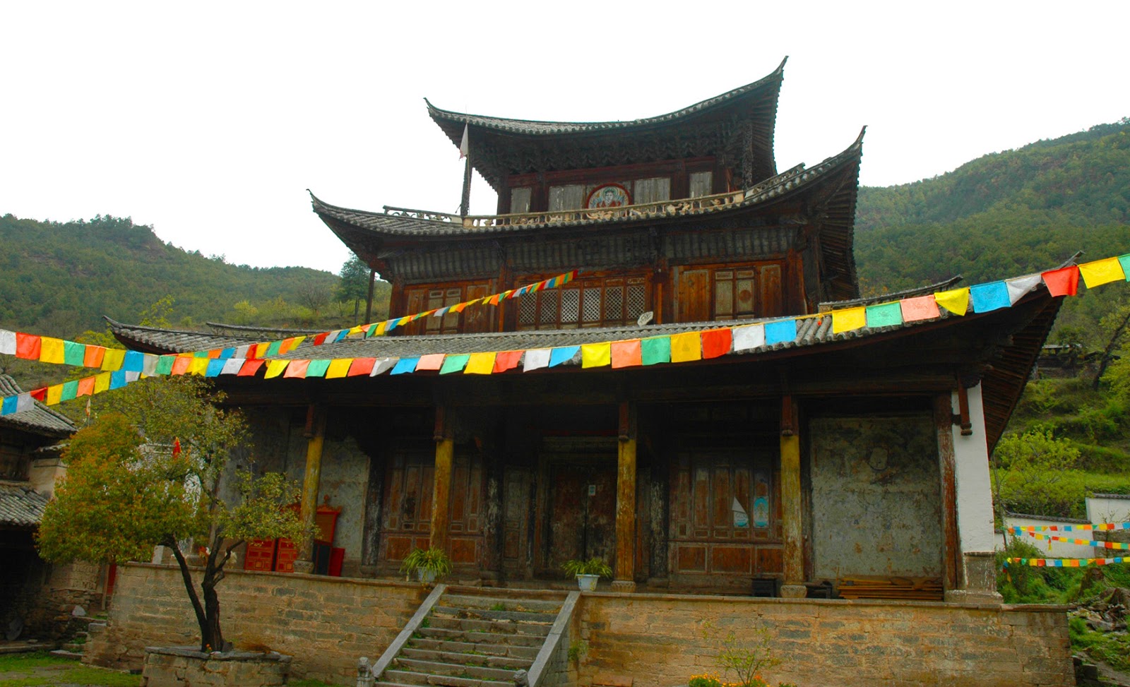
       Nevertheless, two important old Tibetan monasteries have existed in the county since the 17th century.  One is a cave temple in Tacheng district, several km west of the Jinshajiang, the river that divides Weixi and Shangrila Counties.  Known as Damosi, it lies high up near the summit of the mountain, with a few monks’ quarters built next to the mouth of the cave containing the main shrine.  It was named after Damo, an Indian disciple of Siddartha, who is said to have spent ten years in the cave on this mountain and achieved Enlightenment there.
Damosi cave temple
       According to Buddhist lore, the surroundings are imbued with religious symbolism.  Damo is supposed to have left his footprints in the stone here. The mountain 18 kilometers distant from the cave shrine is said to resemble an elephant kneeling before Damo's feet.  The Lapu River running along the southern base of the mountain is like a khada—the ceremonial silk scarf.  West of the elephant's trunk is Damoshan, shaped like a seated Buddha.  The temple was constructed at the mouth of the cave in 1662 and restored in 1984.
       Further west along the Lapu River is the town of Tacheng.  The houses are old-fashioned, tile-roofed types common to rural Yunnan, with modern buildings, and not too high, in the town business district.  A modest new Tibetan temple stands on the eastern side of town.  The town’s population, besides Tibetans, includes Han, Naxi, Lisu and Bai.  But when Tacheng hosts dance troupes for major festivals and other events, most of the performers are Tibetan.
TIbetan dancers in Tacheng
       The show takes place in the main square, graced by a chorten—Tibetan pagoda.  More such chortens can be seen in nearby villages on the road south along the river to Weixi city.  But after that the villages on the hills flanking the river are Lisu, while those alongside it tend to be Naxi.  Some have covered bridges crossing the river, but with unattractive corrugated iron roofs. 
       After a journey of a few hours the road bends away from the river and eventually ends up at the northern end of Weixi, a city bounded by scenic high mountains that climbs up the hill behind the bus station.  Some of the business district buildings still have wooden facades with blocks of tiny windows, just like the old days.  Traditional style houses characterize most of the residential neighborhoods, largely Lisu, where the people still keep ponies to carry goods to and from the market.  Their farms are right next to the suburbs and, like the Lisu in Nujiang, they plow their fields with a pair of oxen, with one man guiding the animals and one man working the plow.
lower Weixi
Lisu in Weixi
       As this is a Lisu Autonomous County, signs on government building gates are in both the Chinese and Lisu languages.  The Lisu language is not written in the government-devised system using Latin letters and letters to represent tones, as on signs in Nujiang.  In Weixi they use the Fraser alphabet, created by an American missionary, using Latin letters, but adding backwards or upside-down letters for special sounds in Lisu.
Lisu on the way to Weixi's market day
       The Lisu accent continues in the artistic plaques erected in the city’s small stadium.  Low-relief sculptures depict Lisu dances, of course, but also hunting with crossbows, spearing buffaloes and planting rice. 
       Compared to the Lisu of Nujiang or southwest Yunnan, the Lisu sub-group around Weixi, and in villages up the Lancangjiang (the Chinese portion of the Mekong), do not dress so splendidly.  The women’s outfit is closer to that of the Naxi, with a back apron and side-fastened jacket over plain trousers or a black skirt.  Market day is not as colorful as elsewhere in western Yunnan, but it will include a few Tibetans selling medicinal herbs and a large section for orchids, which is almost a cult thing in western Yunnan, some of them selling for very high prices.  
central Weixi business district
       While Weixi city doesn’t have any temples, it does have a Christian church atop a ridge just west of the city.  It has a three-tiered steeple, more in the Chinese style than Western, but a long, Western church-style nave.  On Sundays several dozen Weixi devotees, mostly Lisu, come to hear the minister’s sermon.
       The Protestant congregation here is the legacy of American missionaries of the Republic of China era.  But they were not the first Western proselytizers in the area.  French Lazarist missionaries arrived in the region in the 1860s.  In 1867 they established their first Catholic church at Cikou, in southern Diqing County, and in 1870 a second church at Xiaoweixi, northwest of Weixi, 12 km north of the junction of the Yongchun River with the Lancangjiang. 
village above the Yongchun RIver
       Both these churches were built in a style resembling that of Buddhist temples.  The one in Cikou was later destroyed and a new one, looking different, replaced it at CIzhong, a few km upriver.  Xiaoweixi’s church survived intact, though for some years it was converted to a school and then a storage house until the post-Mao era, when worship was permitted again and the church resumed its original function.
       The French established their church at a time when most of the province was experiencing the convulsions of the Muslim Rebellion, which didn’t end until 1879.  It must have been a lonely outpost for the missionaries.  But in 1892 they got a visit from a few of their fellow countrymen when the exploring expedition under the Prince d’Orléans passed through here on their way to search for the sources of the Irrawaddy River. 
Xiaoweixi Catholic Church, built in 1870
       While the scenery along the Yongchun River is quite pleasant, that changes dramatically once the road turns north along the Lancangjiang.  Now it’s high mountains along the river, especially the western side, and beyond them even higher mountains, often with perennially snow-capped peaks.  Lisu villages lie high up near the snow line and streams coming down from Biluoshan, the mountain range on the western side, cut deep gorges as they reach to the river. 
       From Kangpu, one of the larger towns on the route, the mountains are also quite steep on the eastern side of the river and the landscape resembles that in the Nujiang canyon.  Augmenting this notion is the presence of three pairs of rope-bridges between Kangpu and Yezhi. 
Shouguosi
       The highland area is mostly Lisu territory, but the riverside towns like Kangp;u and Yezhi are Naxi.  During the Ming Dynasty, the government of the Naxi chieftain of Lijiang was responsible for frontier security.  As a result, Naxi garrison towns began appearing on the upper reaches of the Lancangjiang, even north of Diqing.
       Badi district, north of Yezhi, is the other major area besides Tacheng with substantial numbers of Tibetan residents.  Yet in the mountains above Kangpu, far even from Badi, is the county’s other major Tibetan temple.  Called Shouguosi, it was founded in the late Ming Dynasty by monks of the Karmapa (Black Hat) sect of eastern Tibet.  The same sect later sponsored construction of a subsidiary monastery at Puhua, near Bingzhongluo in upper Nujiang.
decorated roof at the temple entrance
       Shouguosi sits on a hill about 350 meters above the riverside town of Kangpu.  The road to get there is beyond Kangpu, about six km south of Yezhi, where it zigzags up the forested hill four km and ends at the village.  A mixed population of Naxi, Tibetan, Lisu and Han occupy about 30-40 houses, mostly in the Naxi style, including the traditional pair of wooden fish suspended from the apex of the roof, representing water as a defense against fire and lightning.
        Strings of prayer flags span the lanes leading to the temple, which sits above the back end of the village.  Unusually, it faces west, towards the Biluo Mountains and Tibet itself.  The temple is an elegant old redwood building, with three tiers and gray tiled roofs.  The top tier was added in the mid-Qing Dynasty and elegantly carved posts support the four corners of the roof. 
Bhairab wall mural outside the entrance
       The building has not been renovated since and while some of the exterior color decoration has faded, the carvings on the brackets, of animals and vegetation, are in good condition.  A wall mural of the fierce deity Bhairab near the entry door is mostly intact. And the rows of diamond vignettes of religious symbols that fill the space under the roof at the entrance are unscathed by time.
       In contrast to the muted tones of the exterior, inside the temple is a whirl of color.  Long tubular pendants, covered with flaps of different bright colors, drop down from the ceiling.  New thangkas (religious paintings) and long, narrow pennants hang from the brackets.  Most of the wall murals, generally featuring forms of Bhairab, have been repainted, though a few original, partly faded sections remain.  Gilded bronze statues of Buddha, Avalokitesvar, Padmapani and Tara decorate the altar area. 
       Like the thangkas, these look like recent works and probably donations from outside the immediate area, since there are no nearby Tibetan villages.  From eight to ten monks and novices live there and the village is very religious-minded.  That’s not surprising, since the four different nationalities that live there do so because of their common faith.  Shouguosi monks are very proud of their temple and their tradition and welcome the rare visitor with tea and a khada—ceremonial white scarf.
central market square of Yezhi, old yamen on the right
       Views from around here, and glimpses west through openings in the forest cover on the way back down to the riverside road, reveal steep gorges and high mountains with large swathes of woodlands.  Weixi County still enjoys 36% forest cover, giving it a rich variety of biological resources.  Besides being home to such rare animals as the takin, clouded leopard, pangolin, red goral, golden cat and the snub-nosed monkey, the province’s official mascot, the forests abound in medicinal herbs and plants, edible wild fungi and ornamental flowers like orchids.  Weixi city hosts a trade fair every year to market the county’s medicinal plants, drawing buyers from across the province and beyond.
       Just past the turnoff up to Shouguosi, the road passes between high cliffs that squeeze the river and turn it into raging rapids comparable to those on the Nu River over the Biluo Mountains.  Then a few km later the landscape changes.  The mountains on the east bank stand further away from the river.  A broad tableland spreads out down from their gentle slopes and the town of Yezhi lies at the end of it, just above the river.
Naxi at the Yezhi shops
       A bi-lingual sign at the southern entrance identifies Yezhi as the “Hometown of Lisu Culture.”  Actually, like Kangpu 16 km south, it is mainly a Naxi town and the most impressive old building in the town center is the original Qing Dynasty administrative residence (yamen) of the former Naxi chieftain.  Not in use today, it stands next to the central market square. 
       Naxi women in Yezhi dress very much like those in Lijiang County, minus the ‘seven-starred cape:’ side=fastened jacket in maroon, blue or black, plain trousers and a long black apron.  Occasionally Lisu women turn up in town, usually in modern clothes, but recognizable by their fringed white shoulder bags.  The next village north of Yezhi, on the west bank, is also Naxi, but the settlements above the river, on the edges of high ridges and the slopes of the western mountains, are all Lisu.
       In the 1930s the Morses, an American Protestant missionary family, set up a base in Yezhi.  For several years they evangelized among the then poor, downtrodden, exploited Lisu villages and had great success.  Eventually they moved on to Gongshan County in Nujiang, with similar results, until forced to flee to Burma in 1949.  Today most Lisu in western Weixi County are Christian.
Lisu village near Yezhi
Naxi woman in Yezhi
       Perhaps that’s why they don’t favor their full ethnic outfit for everyday wear anymore.  Some missionary groups sought to eradicate the custom because it pre-dated the arrival of the Word of God.  The Morses’ sect did not make such demands, but at any rate the Weixi Lisu did not abandon it completely.  They still don it for the big Christian festivals, for while Christianity is part of their tradition now, so is their original Lisu identity.

the Lancangjiang in Weixi County
                                                                   * * *   
               for more on the Tibetans in Yunnan, see my e-book Living in Shangrila
                           on the Naxi, see my e-book Children of the Jade Dragon


Saturday, November 19, 2016

In Search of the Hà Nhì in Vietnam


                                                     by Jim Goodman
      
Hà Nhì village above Mường Hum
       By the end of last century I had already begun research in Yunnan’s Ailao Mountains, the range that runs along the southwest side of the Red River.  The area is famous for its ancient irrigated terraces and is dominated by ethnic minorities.  Dai and Zhuang inhabit the valleys, while Hani, Yi, Miao and Yao live in the hills.  Traditional ways were strong in this part of the province.  Nearly all the females preferred their ethnic clothing, old customs and festivals had been revived and economic reforms had improved their material lives.
       The Ailao Mountain range continues into Vietnam and in fact, near the popular tourist attraction of Sapa stands the second highest peak in the range.  Many of the sub-groups of minority nationalities on the Yunnan side also live along the border in northwest Vietnam.  They have different names sometimes:  Hmông instead of Miao, Dao (pronounced Zao) for Yao, Thái for Dai and Hà Nhì for Hani.   Having visited many of them in Yunnan, curiosity about what their life was like on the other side of the border prompted my first visit to Vietnam.  
Phong Thổ
       I was particularly interested in the Hà Nhì because they were the most numerous in Ailaoshan, the minority I knew best and the only one whose language I was somewhat familiar with, up to a point.  They are not very numerous in Vietnam, only about 9000, and in Hanoi at that time I could learn nothing about where they lived.  Assuming they must live somewhere adjacent to where they lived in China, my first attempt began at the Monday market day at Phong Th, northwest of Lai Châu town.        
       Also known by its Thái name Mường Xa, the small town lies beside a river, is backed by hills and is just a short ride to the Chinese border.  White Thái dominate the immediate vicinity, but on market day they were far outnumbered by three sub-groups each of Hmông and Dao, as well as some Giấy and Hà Ngì.  A few women were from the largest sub-group in Jinping County, Yunnan, recognizable by their blue and black jackets and the false braid they added to their hair and coiled it on top of the head.
       A larger group, mostly young women, dressed in blue or pink jackets with embroidered lapels and bands around the sleeves.  The outfit resembled some I’d seen in Yunnan, and local people identified them for me as Hà Nhì, but didn’t know where they lived.  They didn’t speak any Vietnamese, so we never learned.  But later on I never found the identified as one of Vietnam’s Hà Nhì sub-groups, so presumed they came from across the border.
Hà Nhìi n P:hong Thổ
Hà Nhì girli n Phong Thổ
       My next stop was Tam Đường, a pleasant town with some Dao and Hmông in the streets and small hills speckling the urban area.  No Hà Nhì villages nearby, though, and in the Tam Đường Đất Thursday market no Hà Nhì appeared.  However, when I returned to Tam Đường I spotted two young women walking on the street wearing outfits I’d not seen before; long black coats, decorated with silver studs, color trim and bands of color on the sleeves.  I snapped pictures, but there was nobody around to tell me who they were.  Only after I returned to Hanoi, visited the Ethnology Museum and picked up books, I learned they were Hà Nhì, but from Mường Tẻ, the extreme northwest.
Hà Nhì Hoa girl in  Tam Đường
       Even if I had known that then I wouldn’t have reversed directions.  My next stop was Sapa.  High up in the hills, in full view of Phansipan, Vietnam’s tallest peak, with rice terraces cut into the slopes, Sapa bore the closest resemblance yet to the mountain towns I knew in Ailaoshan, Yunnan.  Most of the villages in the vicinity were Black Hmông or Red Dao, but the small yet interesting city museum included displays of the clothing, artifacts and daily life of the Hà Nhì as well, from Bát Xát district to the north.    
       After my museum visit I dined in a restaurant where I sat at a table with the young, personable, bi-lingual, Vietnamese founder of the new Green Sapa Tour Company.  He had himself not yet visited a Hà Nhì village, but to meet them we could go to the Sunday market day in Mường Hum village, west of Bát Xát, which Hà Nhì regularly attended.  That was to be my last full day in the area, so I agreed.       
       We set out at six a.m. on a foggy, drizzly morning and reached Lào Ca in 90 minutes.  From there northwest to Bát Xát was another half hour, but through a flat, boring landscape.  The town had been built on a new location in recent years, but the original village still existed a few kilometers west of the town, and it was also hosting market day that Sunday.  At that early hour it was mostly Giấy setting up stalls, along with a few Dao and Hmông.  This market area was rather small and we pressed on to the much bigger venue at Mường Hum, still another hour away.
      The road ascended into rolling hills and eventually wound down into the riverside town of Mường Hum.  Low-lying villages in the area are Giấy, with well-tended terraces and sturdy, stilted houses, but most people in the market were from the surrounding hills.  Red Dao women dressed a little differently from those around Sapa, with tall, tubular turbans, sometimes decorated with silver ornaments and, except for the babies, the young girls wore the same outfits and turbans as their mothers.  Dao men also dressed in traditional clothes, though less colorful than the women, consisting of plain black, side-fastened jackets and black turbans.
       Three different Hmông sub-groups were in attendance:  the Black Hmông I was familiar with in Sapa, with their black jackets and knee-length trousers; the Flowery Hmông I’d seen in Tam Đường, wearing short jackets and bulky batik skirts embellished with strips of appliqué; and the Red Hmông, whose women extended the length of their hair with red braids.
young Black Hà Nhì woman
older Black Hà Nhì woman
       Fortunately for me, the Mường Hum market also attracted a large number of Hà Nhì women and girls.  I recognized them as the same sub-group that dominates the Jinping Yunnan vicinity and was surprised they lived this far east of Jinping.  In Vietnam they are known as the Black Hà Nhì, after the main color of the women’s outfit—black jackets with colored trimming and plain black trousers.
       Long-sleeved, loose and hanging down to the hips, the side-fastened Hà Nhì woman’s jacket is black with blue or green cuffs and a wide, horseshoe-shaped band of color across the chest.  Usually this band is blue, either plain or with crisscross blue stitching and jackets may also have another band along the sides and lower hen of the back.  Some of the younger women brighten these up with white and red stitching.  Around the neck they wear beads and coins.  They tie long woolen braids to their hair and coil the lot around the top of the head like a turban.  Young girls dress the same as their mothers, but do not braid and coil their hair, but wear a round, ornamented cap instead.
buying sugar cane in the market
Hà Nhì thread sellers
       They had darker skin tones and more angular faces than the Hmông and Dao in the market.  A group of Hà Nhì women occupied a corner of the market square behind a long, low table laden with loops of different colors of mercerized sewing thread.  Dao and Hmông women were their customers.  I decided to approach them and see how far I could get talking to them in their own language. 
       At that time Mường Hum was not accustomed to foreign visitors.  Nearly all tourists in Sapa for the weekend spent Sunday in Bấc Hà, in the hills east of the Red River.  I became quite a curiosity that day just because I was the only foreigner.  After conversing pleasantly with the thread sellers in Hà Nhì, showing them photos of the Hani in Ailaoshan including Jinping, I graduated into a sensation.  ̣(Also shocked the guide.)
       As a result, we learned where the nearest Hà Nhì village was, about five kilometers up the mountain.  It was near noon, the morning drizzle had resumed, so after a quick lunch we drove to the village, nestled in a grove surrounded by undulating rows of terraces.  The houses, with peaked, thatched roofs were the same shape as those in Jinping villages, but with walls of split bamboo instead of brick. 
Hà Nhì village near Mường Hum
      A family invited us inside for a drink and we found the houses had no windows, the only illumination being small oil lamps.  Furniture consisted of mats and stools and a single bed.  We sat around the central fireplace and sipped the local specialty—cassava wine.  I learned they held the same major festivals of the Jinping Hani, the long-table collective feast and the swing festival, but also others for venerating the forests and the water sources.  They relied on their own medicinal plants for treating illness, rather than pills or other remedies from the town pharmacies.  And if that didn’t work, they called on the services of a shaman.  They were obviously poorer than the Jinping Hani, but their only real complaint was that the Dao higher up were drawing off a disproportionate amount of water from the reservoir. 
       The rain picked up, cutting the trip short because the guide worried about the road condition.   We made it down without mishap and I returned to Lào Cai and then Hanoi and then bookstores and museums to learn more about the border people.   As a result, in three months I was back in Vietnam, this time bound for Mường Tè.  This was another rarely visited town, for it was way off the beaten track and foreigners weren’t allowed past the town then.  The nearest Hà Nhì village was a new settlement next to the road, rather modernized and nobody in traditional clothing.  Mường Tè didn’t have a regular market day, so to meet Hà Nhì, I had to hope some mountain dwellers would come to town while I was there.
Hà Nhì woman in Mường Tè
       Another problem was that the local La Hũ minority women dressed in the same outfit as the Hà Nhì.  It’s difficult to determine who took after whom.  The Kucong branch of Yunnan’s Lahu wore the same ensemble, but I’d also seen the same headdress and coat, though shorter, on Hani women across the border in Luchun County.  The nearest La Hủ village was just three km before the town.  But when I tried to visit, just as I caught a glimpse of the women, and before I could take pictures, a scowling, officious man in an army jacket told me foreigners were not allowed in the village.  Go out now.
       I returned to Mường Tè, but as the market was deserted, I spent the rest of the day in the friendly White Thái village just beyond the town.  Other minorities live in the district—Si La, Công, Mảng and White Hmông.  But only a couple Hmông women turned up in town during my stay. 
       I soon discovered one way to tell the La Hủ from the Hà Nhì, even before I had a chance to try speaking with them.  The La Hủ were uniformly skittish.  Mothers hid their babies’ faces, women scurried out of view and even the men looked frightened.  Hà Nhì women just looked at me nonchalantly.  The men nodded a greeting. 
       A Vietnamese shopkeeper informed me the group near us was Hà Nhì, not La Hủ.  Hà Nhì Hoa, he called them, the sub-group called Flowery Hà Nhì, after the vibrant deployment of color on their clothing.  When I told him I could speak some Hà Nhì, he invited them over to meet me.
       They were quite pleased to chat, since we spoke in their language.  I told them of my travels in China other Hà Nhì I’d met, showed photographs and basically led the conversation so we could keep to my limited vocabulary.  One older man could speak Chinese with me, while the market Vietnamese came to join, too.  I could speak a little Vietnamese by then, so it was a tri-lingual encounter.
Hà Nhì Hoa in Mường Tè
headdress of the Hà Nhì Hoa
       As in Mường Hum, I found that the Hà Nhì Hoa basically lived the same way, materially and spiritually, as their ethnic counterparts in Yunnan.  They didn’t have quite the same irrigation system as in Luchun County, where water flows all year down the slope, terrace by terrace.  But they shared the same festivals, customs, type of village shrine and ate the same kind of food that I had observed in Yunnan.
       My encounters with Hà Nhì in Vietnam were limited by time and by government restrictions that didn’t exist in Yunnan.  But besides the information I got from my conversations, there was another trait I found common to Hà Nhì sub-groups in both countries.  They are a friendly, polite, hospitable people, proud of their ethnic heritage and easy to talk with, on either side of the border.

Mường Tè
                                                                           * * *    
         for more on the Hà Nhì, both sides of the border, see my e-book The Terrace Builders


Monday, November 7, 2016

Expanding and Adapting: When the Vietnamese Moved South


                                          by Jim Goodman

 
rice cultivation in the Red River Delta
     
Students of Vietnamese history know that, after over a thousand years of Chinese occupation, in 938 the Vietnamese finally expelled the Chinese and re-established their independence.   Books then go one to tell the story of the dynasties that followed, their defeat of Chinese attempts to take back the country, including three massive Mongol invasions, and the establishment of a distinct state and culture.  This development suffers a jolt in 1407, when the Chinese invade and occupy Vietnam for twenty years until an indigenous guerrilla movement throws them out and its leader founds the Lê Dynasty.  After that, the Vietnamese gradually expand south.
Chùa Dâu, the first Buddhist temple
       This is a summary of the history of the Vietnamese people, but not that of what today constitutes the territory of Vietnam.  The events just narrated concerned only the northern third of the country, called Đi Vit.  The narrow middle section, Central Vietnam, was home to several Chăm kingdoms, while the swampy, very sparsely populated Mekong Delta was part of the Khmer Empire. 
       Đi Vit was the most populated and centrally organized.  With the construction of dikes and canals, ancient Vietnamese had turned the swamps of the Red River Delta into productive rice-growing farms, enabling the formation of states based on agricultural revenue.  The long Chinese occupation didn’t change this, but imposed a Confucian system for organizing both government and everyday life, and introduced Mahayana Buddhism as a state-sponsored religion.
       Chùa Dâu in Bc Ninh province, constructed in the 3rd century, was the first Buddhist temple.  Vietnamese adopted the religion whole-heartedly and it spread throughout the north.  Buddhist monks served as advisors to Đi Viêt’s first kings and the Lý Dynasty lavished funds on temple construction and religious endowments.  Taoism also had its adherents, but in any case, animism never disappeared from the Vietnamese psyche.  The village’s main deity was its own guardian spirit, who was once a living person, quite often a general who fought northern invaders.
Quố Tử Giàm, the National University
       Like their former overlords, the Vietnamese followed Confucian ideals in everyday life, such as ancestral veneration, social hierarchies, models of behavior and respect for learning.  Confucian norms also characterized the government.  In 1076 the Lý Court established a National University (Quc TGiàm) to train officials.  Confucian classics dominated education.
       Besides the periodic invasions from Chins, Đi Vit also had problems with the Chăm kingdoms on its southern frontier.  Chăm people began migrating into Vietnam from the Philippines and Indonesia two thousand years ago, establishing different kingdoms along the coast of Central Vietnam from the late 2nd century, influenced by their Khmer neighbors to the southeast.  The religion was Hindu, the temples modeled on Khmer architecture and sculpture, the rulers god-kings, identified with Shiva, with occasional monarchs, as in Cambodia, Mahayana Buddhists.
Chăm Court, Đà Nẵng Chăm Museum
       The main difference between Chăm and Khmer kingdoms was that the Chăm were also great seafarers and supplemented their agricultural economy and national wealth by trading in ports throughout Southeast Asia.  After the 8th century, many of those involved in the maritime trade with Indonesia became Muslim, though Hindu Chăm still comprised the majority of the population. 
        They were also a very bellicose people, involved in frequent wars with Khmer princes and each other, as mercenaries for one Khmer contender for Angkor’s throne against another, and sometimes in alliance with the Khmer against the Vietnamese.  Northern Chăm states made a habit of raiding southern Đại Việt districts from the time of the Chinese occupation. The eventual Vietnamese response was always a punitive expedition that forced the Chăm to cede their own northern districts to Đái Việt. When Vietnamese began settling in these acquisitions the Chăm would start raiding them, provoking another expedition and another annexation.
Bánh Ít Chăm towers in Bình Định
       By the 14th century, the Vietnamese had pushed the Chăm south of Quảng Nam.  But the largest Chăm kingdom, Vijaya, with its capital in present-day Bình Định province, rose to new strength later that century under the charismatic King Chế Bồng Nga.  For nearly two decades, starting in 1371, he launched several invasions of Đại Việt, sacked the capital twice and would have done so a third time, but was killed by Vietnamese artillery after a defector had revealed which ship he was on.
royal court, Lê Dynasty
       Some decades later, grossly underestimating his enemy’s strength, the King of Vijaya resumed raids on Đại Việt territory.  However, his opponent this time was Lê Thánh Tông, the Lê Dynasty’s most talented king, who was determined to end the Chăm menace once and for all.  With an overwhelming invasion force, backed by the latest artillery technology, he captured Vijaya, obliterated its defenders and annexed the state, extending Đái Viết’s borders down through Phủ̉ Yên.  Many Chăm fled by sea north to Hainan Island, east to Cambodia or south all the way to Acheh, Indonesia. Others moved to the hills or simply stayed, adopted Vietnamese names and assimilated to the new order.
       Lê Thánh Tông then set up an immigration system of military colonies to promote Vietnamese settlement in the conquered territories.  But aside from political exiles, runaway convicts, criminals and dubious adventurers—the usual frontier riffraff—nobody went south.  Vietnamese are very conservative and don’t like to leave their ancestral lands without a serious compelling reason.
countryside near Huế--the heartland of old Thuận Hoá
       After two decades of four successive depraved, bloodthirsty, reckless and incompetent teenaged kings (with absolute power), each of whom was killed at the end of his rule, in 1527 Mạc Đăng Dung, the Court security chief, seized power and started a new dynasty.  Lê followers escaped to Laos and several years later launched a protracted war against the Mạc regime.  Every few years contending armies marched across the Red River Delta territories, conscripting every able-bodied man in the villages, fought furious battles, beheaded all their prisoners and retreated to regroup and campaign again later.
       In many places there were no men left for agricultural work.  Dikes fell into disrepair, rice fields became weed patches and famines stalked the land.  This bleak situation provided the motives for emigration, not over-population.  Đại Việt’s population fell sharply in the 16th century, especially in the Delta.  Life became untenable in the ancestral homelands.
       Vietnamese had already been settling in Thuận Hoà, the area below Quảng Binh down to the Hải Văn Pass near Đằ Nẵng.  Their numbers multiplied in the 16th century, while some continued on to Quảng Nam and former Chăm areas further south.  They were refugees fleeing a land they had no hope of returning to, pioneers that included hardy farmers, skilled crafts workers, canny merchants and dedicated soldiers.  
Thiên Mụ Pagoda
      Up north, two rival families, the Trịnh and Nguyễn, allies and inter-married but suspicious of each other, led the Lê forces.  Trịnh Tùng commanded the forces that drove the Mạc out of the capital in 1592 and installed the restored Lê king as a figurehead, keeping real power himself.  His rival Nguyễn Hoàng had been governor of Thuận Hóa since 1558 and made it his own autonomous fief.  He set up an efficient administration, dominated by military officers, and essentially broke away from the Lê government by refusing to send taxes back.  Visiting the Perfume River in 1601, he sponsored the building of the Thiên Mụ Pagoda, still standing and a major tourist attraction.       
       When he died in 1613 the country was effectively split.  The Trịnh Lords of the north were not yet strong enough to compel the Nguyễn Lords’ submission, but Nguyễn Hoàng’s capable successor, Nguyễn Phúc Nguyên, knew the showdown was imminent.  He married off one of his daughters in 1623 to Chay Chetta II, King of Cambodia, to insure the supply of war elephants and rice to his small and vulnerable realm.  To secure his southern flank, he also married off another daughter to Pôrômê, the Chăm King of Panduranga, south of former Vijaya.
       The long-expected invasion came in 1627 and the southerners turned it back. They resisted more invasions in the next decades and made one unsuccessful campaign into the north before finally, in 1672, the two sides signed a truce, dividing the country at the Ghanh River just above Đồng Hợt, Quảng Binh. 
       These campaigns were intermittent, leaving the south long periods of peaceful development.  Vietnamese settlers, less tradition-bound and more open to changes than they were up north, made several adaptations in the new lands, where they would be a minority for generations to come.  Farmers found the soil in Thuận Hóa the soil was different from that up north.  The plow they used there was not very strong in the sole or the blade, light enough to be drawn by a single animal, and quite suitable for the less compacted soil of the Delta.  But it would not work well with the thick grass and harder soil of Thuận Hóa.  So they used the Chăm plow, stronger in the sole and better suited for the fields.  Then they improved it by adding a part to alter the angle of the blade.
Pô Nagar, the main Chăm goddess
whale temple wall, Bạc Liêu
       The immigrants took to eating some of their food raw, like the Chăm, and wrapping their hair in headscarves, male and female, like the Chăm.  They also adopted the Chăm way of capturing, training and using elephants.  Northern armies had been using elephants in warfare for a long time, but now Vietnamese, like the erstwhile Chăm kings, also employed them as royal entertainment and to execute criminals.
       In spiritual matters, too, Chăm culture influenced immigrant Vietnamese.  The latter erected new temples on the site of ruined Chăm temples because they accepted the Chăm belief that the particular site was charged with holy power.  They adopted the cult of the whale, Cá Ông, in Phú Yên and took it with them further south.  Most significantly, they incorporated Pô Nagar into their own cult of the Holy Mothers, one that had only become part of Vietnamese culture since the 16th century.  They renamed her Thiên Ý A Na.
Khleang Temple, Sóc Trăng, originally built 1533
       After the truce with the Trịmh Lords, the Nguyễn regime focused on the south.  By this time Cambodia had fallen into a long series of succession struggles among its royal princes.  Since Nguyễn Phúc Nguyên’s daughter married Chay Chetta II, Cambodia had become weaker and the Nguyẽn Lords’ realm stronger.  Rival princes needed outside help to win and in return for Vietnamese help; ceded provinces in the Mekong Delta over which the Cambodian government had had no control for centuries. In this way, the Vietnamese were able to set up direct administration of Saigon in 1698 and in the following century gradually annexed the entire Mekong Delta.
       The Mekong Delta at that time was mostly an uninhabited swamp.  The Khmer lived mainly near the mouth of the Mekong, far from Cambodia proper, in communities virtually autonomous since their founding.  Vietnamese migrants did not displace them, but moved into the adjacent areas and beyond, cleared the swamps and created big rice plantations.  Local Khmer by then were Theravada Buddhists and while that did not influence the migrants, they did adopt the custom of field shrines to the land spirit, the use of split palm leaf to make houses, Khmer farming tools and the types of rice grown.
Khmer house of split palm leaf
       The late 17th century also saw the introduction of Chinese settlers in the Mekong Delta, when political refugees were allowed to settle in Biên Hoa and Mỹ Tho.  Other Chinese refugees established the port of Hà Tiên, now on the southwest border of Cambodia.   Vietnamese were still a minority, but their numbers increased with the arrival of Vietnamese Christians fleeing periodic persecutions by the Nguyễn regime. 
       By the mid-18th century the Nguyến regime was in decline.  The Tây Sơb revolt, named after a village in south central Vietnam where it began, broke out in 1771 and in a few years overthrew the regime.  They later went on tọ conquer the Trịnh regime in the north.  The Nguyễn family escaped to the south, but the rebels caught up with then and massacred every member except the teenaged prince Nguyễn Ánh.  The next chapter of Vietnamese history is the story of how this indomitable prince waged a 25-year campaign to finally defeat his Tây Sơn opponents.
Chinese stage show, Hồ Chị Minh City
Chợ Lợn Chinese market, Hồ Chí Minh CIty
       After several reverses and recoveries, he consolidated control over the Mekong Delta and used this as his base to slowly, methodically advance north.  As his close friend and advisor, as well as link to Western military technology, was the French priest Pére Pigneau, Nguyễn Ánh tolerated the practice and spread of Christianity.  He also promised local autonomy to the Chinese, Khmer, Chăm and other non-Vietnamese communities in return for their support for his cause.   And he kept those promises after victory.
       With this multi-ethnic army, Nguyễn Ánh ultimately rolled into the northern capital in1802, terminated the Tây Sơn regime, founded the Nguyễn Dynasty and took the reign name of Gia Long.  His triumph was more than just the restoration of his family’s power.  This was a new country, Vietnam, bigger and more culturally enriched than Đại Việt, with the boundaries it still has today.
 
Vietnamese-made canal in rural Vĩnh Long
                                                                           * * *   
                  For the full story, see my book Delta to Delta:  The Vietnamese Move South