Showing posts with label Lancangjiang. Show all posts

Thursday, June 24, 2021

Beyond Shangrila: the Mountains of Deqin


                              by Jim Goodman


       Mountains in Yunnan rise higher the further northwest you go in the province.  They top more than 4000 meters in Dali Prefecture and over 5500 meters near Lijiang.  There are other 4000+ peaks in Ninglang County and upper Nujiang, but the biggest of them all lie in Deqin Autonomous Tibetan Prefecture, for most of its territory is geographically the southeastern tip of the Tibetan Plateau.  Here the mountains stand over 6000 meters.

       The most accessible and popular part of the prefecture is Shangrila County.  It used to be called Zhongdian until 2001 when, to promote its tourist potential, the government claimed it was the site of the Shangrila of James Hilton’s famous novel Lost Horizon and so officially changed its name.  With its broad plain, traditional Tibetan houses, lovely monasteries at Songzhanlin and other places and friendly people, it certainly appeals as an idyllic escape from the commotion of wherever the tourists came from.

       The Shangrila hype notwithstanding, the village of the novel had a very different setting, in a valley with a triangular-peaked snow mountain towering over one end.  Shangrila lies at about 3100 meters and from various points in the county, especially in winter, one can see some snow around the mountains beyond the plain.  But they are not very high and to see anything resembling the mountain described in Lost Horizon one has to go further on to Deqin, the next county north.

       Not long after leaving Shangrila city, after passing Napahai Lake, the landscape abruptly changes.  From here on the topography is all mountainous, with no more broad expanse of relatively flat land.  The road runs along the higher parts of the mountain slopes that, in the early 90s during my visits, were largely denuded of trees, with stray hamlets clinging to the hillsides. Then it descends to cross the Jinshajiang, the River of Golden Sand that is the moniker for the Upper Yangzi, and soon pulls into Benzilan, the first major town in Deqin County.

       There were two Benzilans then.  In the lower one, the original Tibetan settlement, the houses lined a ridge overlooking a small plateau that served as farmland and pastures.  The upper one was the commercial center along the main road, full of shops, hotels and restaurants catering to travelers on the Shangrila-Deqin route, most of whom stop here for lunch.

       From Benzilan it’s up into the mountains again, where the slopes are high and barren again, although not necessarily due to deforestation.  Many gradients are so steep they never supported forests anyway. But streams run down them and there, on modest gradients, Tibetans built their settlements that are patches of green in the otherwise dusty brown landscape.   Around 15 km from Benzilan a turn-off takes one a short distance to a dramatic view of a bend in the Jinshajiang,  The river makes a loop 2/3 the way around a conical hill  protruding from the vertical cliffs on the eastern bank.

       Back to the road, the next stop north is the monastery of Dongzhulin, 103 km north   of Shangrila, at an altitude of 3000 meters.  The original monastery lay further away from the road and was built in 1667 during the reign of the Kang Xi Emperor, who himself was interested in Tibetan Buddhism.  In the 19th century Dongzhulin housed over 900 monks and 12 Living Buddhas (reincarnations of famous lamas).  It was here that the French missionary Père  Renou disguised himself as a trader and stayed to learn about Buddhism and to speak the local dialect in order to, after he left the monastery, proselytize Christianity among Deqin’s Tibetans.

       Dongzhulin became associated with the Tibetan Revolt in 1958, allegedly storing arms for the rebels, and in retaliation government forces leveled the monastery.  In 1985 it was rebuilt in its current location, a splendid traditional-style building, four stories high and supported by 82 thick wooden pillars.  The ground floor houses large images of various deities like Tsongkhapa, the founder of the Gulugpa (Yellow Hat) monastic order, Avalokitesvar, Manjusri and others.  Portraits of celestial beings, demons, benevolent and wrathful deities fill the walls.  The 3rd floor features huge images of the Maitreya Buddha, seven meters high, and Sakyamuni, ten meters high.  The other floors are for reciting sutras and performing private rituals. 

       In the early 90s Dongzhulin had about 300 monks and one Living Buddha.  There was also a Buddhist nunnery attached to it.  Nuns follow the same rules as monks, shave their heads, wear robes, recite sutras, etc, but have the option of staying in the nunnery or living at home.  Most stay in the nunnery across the road in Shusong. 

        From here it’s another 80 km or so to the county capital and halfway there the road runs through a forest and over a pass at 4000 meters.  The peak of Baimashan looms to the left of the road.  Though only 4292 meters high, it is perpetually covered in snow.  The pastures on the edge of the forest are prime yak grazing areas in the summer months.  The whole area is a protected nature preserve, home to foxes, deer, leopards and bears.  The poplar trees and parts of the pine groves turn yellow in autumn and local species of the maple tree turn red.

       From the pass the city is another 35 km through stony hills with thin patches of forest and scarcely any human habitation until just before the city.  Formerly called Atuntse, and known to local Tibetans as Jui, Deqin is about half the size of Shangrila and at around 3400 meters a slightly higher altitude.  It is sited on slopes that funnel precipitation down to a stream at the lower end of town that eventually empties into the Lancangjiang (Upper Mekong).  Most of the buildings then were modern concrete structures, with a quasi-Tibetan style in the upper end neighborhood and no style at all elsewhere.

       The only remaining wooden buildings were around the central market, which was about half the size of Shangrila’s but less ethnically diverse, for nearly all the city’s residents are Tibetan.  Several shops here and on the main street specialized in Tibetan clothing, crafts and jewelry.  City residents and villagers come here to sell off heirlooms, furs and herbs and purchase Tibetan belts, scarves, carpets, woolen cloaks, brocaded silk, fur hats and ornaments of coral, turquoise and silver.

       Most Deqin women, though, didn’t seem to be as fond of wearing traditional clothing as in Shangrila County and when they did the outfit resembled  more the style of Lhasa, with an ankle-length dress and a long striped apron in front, rather than the ensemble popular in Shangrila County.  On the whole, they were not as outgoing or engaging as their counterparts in Shangrila/Zhongdian, but invariably polite and cordial.

       Deqin has a mosque, not for Hui but for Tibetan Muslims who converted to Islam when part of Hui-run caravans in the past.  The population is overwhelmingly Buddhist, but the devout had to journey to villages beyond the city, as Deqin had no big monastery of its own anymore.  During the Qing Dynasty, especially in its last decades, lamas from high-ranking Tibetan families ruled Deqin as their private fief.  Around the end of the 19th century two new developments began to challenge their practical autonomy.  Under pressure from France, the Qing government allowed French missionaries to proselytize in Tibetan areas.  At the same time the government inaugurated a land reform policy in these same areas.

       Both of these threatened the lamas’ authority.  Land reform would target their own family holdings and conversion to Catholicism would undermine their religious leadership.  In 1904, the British colonial Government of India authorized the Younghusband Expedition, a military invasion of Tibet ostensibly designed to prevent the Russians from taking it.  London disapproved of the move and the following year Younghusband’s forces withdrew.

       Among the Tibetans the incident provoked outright rebellion against anything and anybody foreign.  In 1905 a widespread uprising began at Batang in southwest Sichuan, where the lamas instigated attacks on the foreign missionaries, all their converts and Chinese government officers.  Victims suffered grisly deaths, especially the priests, and the rebellion spread to Litang and Kangding in Sichuan and down into Yunnan in Atuntse/Deqin.  Massacres of priests and their followers took place in Deqin and Cikou, the French mission in the Lancangjiang valley south of Deqin.  Marauders mounted the severed heads of the priests on the Dechenling Monastery gate in Deqin.

       Chinese government forces halted the rebels’ advance on Xiaowieixi, the next Christian settlement south of Cikou.  They then marched on Deqin, isolated and surrounded the lamas in Dechenling and finally slaughtered everybody inside and burnt the building to the ground.  Chinese officials took charge of the administration, but eventually married local women and stayed on after their service was completed.  Surviving Christians rebuilt their demolished church in Cizhong, a little north of Cikou, this time in a French village style.

       The main reason travelers go to Deqin is not for the city’s few attractions, but for the view of the nearby snow mountains. On a clear day this is truly magnificent.  Leaving Deqin the road heads towards the Lancanjiang and after climbing out of the city’s valley and into the countryside, doming to Dong village and the modest Feilai Temple, surrounded by grain fields.  Inside the main hall is a large statue of the mountains’ guardian deity.  In the annex, when I visited, the carcasses of freshly killed goats hung from the rafters.  As the monks were presumably vegetarian it wasn’t their food.  Some Bon, pre-Buddhist sacrifice? I wondered, but never did find out.

      Lovely  Taizishan Snow Mountain, 6054 meters altitude, is visible from the approach to Dong.  A little further on, at a small break in the forest, is the most celebrated viewpoint.  Looking west one can clearly see Meili Snow Mountain, at 6740 meters altitude the highest in the province.  From its peak a long wide glacier runs down in front.  This is the most accessible glacier in Yunnan and in later years tour companies promoted one-day hikes to it and back or overnight camping at the glacier’s foot.  Adventurous travelers could also go on extended treks in the nature preserve around the mountain.

       On my visit the viewpoint also featured several chortens and strings of prayer flags, adding a religious aspect to the scene.  After a few years the government built a high wall between the road and the viewpoint with a ticket booth in front of its only door.  The entry fee was 150 yuan.  On my visit it was free.

       The road continues along the Lancangjiang Valley all the way to the Tibetan border, passing both forested and barren areas and through tunnels chiseled out of the cliffs.  It is a good example of Yunnan’s road engineering skills, though occasionally subject to landslides, which are always quickly restored.  Herder take their yaks along the same road and wherever fatal accidents have occurred, people have erected chortens on mounds of stone slabs inscribed with Tibetan prayers.

       About 30 km north of Deqin the road swerves away from the valley to cross the Adong River.  Upstream stands a major hydroelectric plant and a switch pulled here daily around midnight plunged Deqin and vicinity into darkness.  Further up, 64 km from Deqin, lies Foshan, a nondescript town from where the Lancang River is the provincial boundary between Yunnan and Tibet.  Just past Foshan is the rather prosperous village of Nagu, famous for the ancient stone coffins found nearby, but unfortunately they had been removed to a museum by the time of my visit.  Another 40 km is the Tibetan border, with an old Naxi settlement on the way, a relic of the early Qing Dynasty when Naxi troops from Lijiang guarded the border.

       While the mountains south of Taizishan are not as high or dramatic, the scenery all the way to Cizhong is quite impressive.  A road from the south end of Deqin winds along narrow gorges cut by the Lancangjiang’s tributary streams, offering sporadic glimpses of the snow peaks, passes through three tunnels and then makes eight distinct bends on the descent to the riverside town of Yunling.

       From Yunling the road runs along the Lancang River, with excellent views across to isolated villages, monasteries perched atop ravines, deep gorges cut by streams, splendid tall, thin waterfalls spillling over sheer cliffs, and occasional thick forests that burst into a variety of colors in autumn.  Around Yanmen, 30 km south of Yunling, Nagu-like stone coffins have also been found, including remnants of ancient pottery and bronze artifacts.

       A little downriver on the opposite bank lies the county’s last major attraction—the Catholic Church at Cizhong.  Tibetans comprise 3/4 of the population, with Naxi at 20% and Han 5%.  The altitude is sufficiently lower here so that Cizhong farms can grow rice instead of barley.  Viniculture, introduced by the French missionaries, is also prominent and Cizhong has a reputation for its wine.  Tibetan Christianity never revived in Deqin, but here in Cizhong, in spite of 1905, it survived.  Its congregation is mostly the older generation, but its very existence puts Cizhong on the list of what-to-see for any traveler seriously exploring Deqin County.


                                             * * *                                               

For more on Deqin and the Tibetans, see my r-book Living in Shangrila


Monday, September 28, 2020

Through Yunnan to India, 1895


                                  by Jim Goodman


       One of the consequences of the European conquest of most of southern Asia was an insatiable interest in the region’s geography.   European-made maps at the time were full of blank spots or, at best, rough guesses of the exact location and height of certain mountains and the sources and accurate courses of major rivers.  Ambitious individuals in the academic world sought to make their reputations by answering important geographical questions.

       By the late 1880s Great Britain had already taken over northern Burma and France had seized northern Vietnam and Laos.  That put both countries’ possessions on the border of Yunnan, at a time when Chinese central authority was in the throes of collapse.  Both wanted to open Yunnan up to trade, so information on the province was at a premium.  The only serious Western attempt so far to explore Yunnan was the French Mekong Expedition in 1868.

       Looking for a river route to China, the expedition found that way blocked by the impassable Mekong Falls in southern Laos.  The group continued anyway on foot and eventually entered Yunnan through Xishuangbanna.  From Jinghong they carried on to Kunming and wanted to turn towards Dali and reach the Mekong again west of Dali.  But Yunnan was engulfed by a brutal civil war and the explorers could not get permission to go west, which terminated their tour of the province.

       A generation later, at the beginning of 1895, another French expedition set out to explore Yunnan, planning to enter from Vietnam, head west for the Mekong River (called Lancangjiang in China) and follow it north to Tibet.  The organizer of this journey was Prince Henri d’Orléans, a veteran traveler already familiar with Madagascar, parts of western China and Cambodia.  He originally intended to explore Vietnam’s Central Highlands, but discovered others already had.  He preferred somewhere that was as yet unknown.  In Yunnan he would deliberately take a different route than his countrymen followed in 1868.

       Joining the Prince were Émile Roux, a navy acquaintance, and Pierre Briffaut, a French colonist from Hanoi.  The trio and their entourage sailed up the Red River from Hanoi to Lào Cai, crossed Yunnan in early February and sailed for three days to Manhao, which was as far as boats could go.  They then headed for Mengzi, site of a French Consulate, where they organized their supplies and needs for the next part of the journey. 

       From Mengzi they returned to the Red River, marched as far as Honghe and then turned south into the hills.  A landscape they had never seen before awaited them, of irrigated rice terraces up and down the slopes of the hills.  As this was late winter, the terraces were at their most picturesque, filled with water that reflected the sky.  The inhabitants were Hani, an ethnic group unfamiliar to the party, who believed them to be the area’s aboriginals.

       Both the Prince and Roux took copious notes everywhere.  Briffaud did not.  He was basically along for the adventure.  But he was assuredly a welcome companion around the campfires, especially when the going got rougher later on.  A devoted geographical statistician, Roux took down all the numbers for the latitudes, longitudes and altitudes, made short descriptions in a journal and later wrote up a fuller account in France.  This included other observations, like his description of how the Hani bowed deeply to them when encountered on the trail and carried on their backs loaded baskets using head-straps.  He described the entry gate to a Hani village, with its carved figures designed to keep out evil spirits, a custom still in practice in many Hani villages.

       The Prince specialized in natural studies and so recorded all the species of birds, insects, mammals and flowers he discovered on the way.  Linguistics was another major interest and he collected rudimentary vocabulary lists for over thirty languages and dialects.  Long before Joseph Rock, he discovered the Naxi dongba pictograph books and collected several of them, along with samples of the Yi language script.

       From the southwest corner of Honghe County the expedition turned west for Simao (now called Pu’er), the first town of any size since Mengzi, for a brief rest, more supplies and more information on what lay ahead.  Heading west towards the Lancangjiang, they enjoyed the scenery, especially when passing the white boulders jutting out of land and water at Cuiyun.  When they reached the river they turned north to follow its course however far they could.

       Actually, they rarely marched alongside the river and mostly kept a little to the west of it.  The group stopped for a break in Lincang, a small town of 5000 inhabitants, half the size of Simao, then continued to Yunxian and Fengqing.  Just past this town they crossed the Lancangjiang again and struck for Dali.

       In Dali they stayed with a French mission, where the explorers could speak French again for the first time since Mengzi.  They arrived the last week of May and made this a major stopover, staying over two weeks, especially enjoying the scenery of the lake, eating beef for the first time in many weeks, sampling the Lijiang wine known as yinjiu, and organizing the next phase of the trip.  Dali was still affected by the Muslim Revolt and supplies, including thirty mules, had to be procured in Xiaguan.  They also recruited nine Chinese, including one called Joseph, a Christian who had learned Latin.  The Prince had also studied Latin as a schoolboy and could remember enough to converse, more with use, and so Joseph wound up becoming their interpreter, remaining with the explorers the entire journey.

       Finally on the move again, the group trekked past Erhai lake to Dengchuan and then turned west towards the Lancangjiang, via Yunlong.  When they reached the river they only followed it north a short distance before being seized with a new goal—to cross the Biluo Mountains to Liiuku for a look at the Nu River.  This was the name of the Salween River in China and virtually nothing was known about it.  Local people advised against it claiming the valley was full of dangerous vapors and the mountains inhabited by warlike Lisu.

       The explorers didn’t believe any of that.  Throughout the journey people had frequently told them to beware of the next destination, which always turned how to be a great exaggeration.  The crossing wasn’t easy and they had to spend a night in the forest, but descending to Liuku they did find the weather sultry and hotter, though they did not suffer any new health problems.  They turned north up the Nu River halfway to Chenggan, then crossed over the mountains to return to the valley of the Lancangjiang at Biaocun.  From here they could hike right along the river all the way to Deqing.
       Heading north again, they soon came to their first rope-bridge.  They’d never seen this unique way to cross the river, but the guides instructed them how to use it.  Not only the travelers, the mules and all the baggage had to be moved to the other side the same way, which took the entire day.  They would use more of these in months to come and the only mishap occurred below Deqing, when Roux’ pet dog, seeing its master swinging over the river, tried to follow him by swimming across, but the rapids swept it away.

       Sheer riverside cliffs popped up all along the trail, necessitating another rope-bridge crossing or a march up and over the blocking mountain.  Often these mountain paths were quite narrow and slippery and once two of the mules tumbled down the slope.  They recovered them fortunately.  Local inhabitants were mainly Lisu, a branch without the querulous reputation of Nujiang’s Lisu and were more than hospitable.  They assumed the explorers were government agents and unloaded their complaints to them.  They also wined and dined their guests, introduced them to the ‘one-heart drink,’ with a man and woman quaffing the rice-beer together sharing a single large bamboo cup, and treated them to dance shows.  

       While the route got more rugged the scenery grew ever more impressive, with views of distant, snow-capped mountains in view.  They stopped briefly at the French Lazarist mission in Xiaoweixi, again meeting old priests who hadn’t had a chance to speak French for ages.  They continued to the Naxi settlement of Yezhi and then on to the Tibetan lamasery at Kanpu.  By chance, they arrived in time for Huobajie, the summer Fire Festival celebrated by most ethnic minorities in the northwest.

       Three days later they reached Cikou, also a Lazarist mission with two old very welcoming priests.  Less harassed by Chinese officials, this was a more successful mission than Xiaoweixi, with a large number of Tibetan converts.  Upon arrival, though, the Prince fell ill with bronchitis and fever, requiring rest and medication for a few days.  Roux took the opportunity to satisfy his geographical curiosity with a trip to Deqing, taking along Joseph and one other.  He became familiar with Tibetan chortens made of slabs of rocks inscribed with prayer, barley flour (tsampa), bettered tea and the highest mountains in the province, but found the town itself unfriendly and without interest. 

       The Prince had recuperated upon Roux’ return and by now, with the Tibetans having made it clear the group could not enter Tibet, the explorers conceived an alternate ambition.  They would try to locate the sources of the Ayeyarwady River, which would be a new contribution to geographical knowledge of Southeast Asia.  Britain had seized northern Burma a decade earlier, but their maps had designated most of the extreme north as ‘unexplored territory’.

       The expedition marched up to Yanjing and then crossed the Biluo Mountains to their west, reaching the Nu River via Dimaluo, crossing by dugout canoes at a rare calm stretch of the river and stopping for a few days at Gongshan for rest and resupply.  At this stop they sent their mules back to Cikou with a few of the crew, for animals were becoming an impediment to progress the rougher the trail became.  They hired 24 Tibetans as porters, as well as a Dulong guide who also spoke the Nu and Lisu languages.

       To get to the ‘unexplored territory’ they had to go west from Gongshan over what decades later became the caravan route to Dulongjiang.  It was not much used back then and sometimes they had to reconstruct part of the trail or make dangerous detours along very narrow mountain paths, propped up by logs and boulders along steep cliffs.  For the first part of the journey they stayed in Nu villages, finding the people very polite, almost subservient in their desire to please, very poor materially, but healthy and strong, with several octogenarians each village, something rarely found elsewhere back then.

       More discoveries ensued when they climbed over the Gaoligongshan range and descended to the Dulong River Valley.  Many of the plant and tree species were different from those in Nujiang.  The river was blue-green and cold.  They learned that it began at the north end of Dulongjiang district, so was not a tributary of the Nu, but could be one of the sources of the Ayeyarwady.  By following it through northern Burma they would find out.

       The Dulong people were even poorer than the Nu, but also very hardy and strong.  They were shorter than Nu or Lisu and were apparently related to the Nu, for their language was similar and unlike Lisu.  Many, though not all, of the women had tattooed faces, a custom allegedly adopted to discourage marauding outsiders from kidnapping their women.  They lived in hamlets of less than ten thatched roof houses.

       Several Dulong men joined the expedition, replacing Tibetan porters who did not want to travel to Burma.  Some were familiar with part of what lay ahead and either knew which routes were the less strenuous or how to quickly clear a new trail to replace one washed out by a flood or blocked by a landslide or construct a new bamboo bridge.  When food supplies ran perilously low a few Dulong took their crossbows to the jungle and returned with a few big birds.

       The trail was the worst yet taken, full of various obstacles, with signs of human habitation rare.  After crossing the Telo River, a major tributary of the Dulong River, they marched six days without meeting anyone.  Finally they arrived at Putao, run by a Khamti chieftain, whom they had to persuade/bribe that they were not British spies.  At least they could eat decent meals again but had to surrender almost all personal belongings, except their boots and rifles, to pay for supplies. 

       They left Putao for India, but Roux suddenly got very sick and had to stay in a village while the Prince continued to India and arranged relief.  Roux recovered and the group carried on to Assam, India, reached Sadiya and from there could go by boat all the way to Calcutta.  Back in France, the Prince d’Orléans and Roux both wrote up their adventures and became academic celebrities for having proven that Yunnan’s Dulong River was indeed a major source of the Ayeyarwadi River.


                                                                      ***      


Sunday, November 27, 2016

Wandering Around Weixi County


                                              by Jim Goodman

Tacheng TIbetan neighborhood
       Anyone wishing to meet or research Tibetans in Yunnan goes to Diqing Tibetan Autonomous Prefecture in the northwest.  Tibetan villages lie all over the high plateau and rolling hills of Shangrila County and speckle the steep hills of the more rugged Diqing County, backed by the highest mountains in the province.  Most of Yunnan’s Tibetans live in these two counties, but some also inhabit nearby districts in Weixi, the prefecture’s other county, a Lisu Autonomous County, where Tibetans are a minority and Lisu constitute over 60 % of the population.
       Nevertheless, two important old Tibetan monasteries have existed in the county since the 17th century.  One is a cave temple in Tacheng district, several km west of the Jinshajiang, the river that divides Weixi and Shangrila Counties.  Known as Damosi, it lies high up near the summit of the mountain, with a few monks’ quarters built next to the mouth of the cave containing the main shrine.  It was named after Damo, an Indian disciple of Siddartha, who is said to have spent ten years in the cave on this mountain and achieved Enlightenment there.
Damosi cave temple
       According to Buddhist lore, the surroundings are imbued with religious symbolism.  Damo is supposed to have left his footprints in the stone here. The mountain 18 kilometers distant from the cave shrine is said to resemble an elephant kneeling before Damo's feet.  The Lapu River running along the southern base of the mountain is like a khada—the ceremonial silk scarf.  West of the elephant's trunk is Damoshan, shaped like a seated Buddha.  The temple was constructed at the mouth of the cave in 1662 and restored in 1984.
       Further west along the Lapu River is the town of Tacheng.  The houses are old-fashioned, tile-roofed types common to rural Yunnan, with modern buildings, and not too high, in the town business district.  A modest new Tibetan temple stands on the eastern side of town.  The town’s population, besides Tibetans, includes Han, Naxi, Lisu and Bai.  But when Tacheng hosts dance troupes for major festivals and other events, most of the performers are Tibetan.
TIbetan dancers in Tacheng
       The show takes place in the main square, graced by a chorten—Tibetan pagoda.  More such chortens can be seen in nearby villages on the road south along the river to Weixi city.  But after that the villages on the hills flanking the river are Lisu, while those alongside it tend to be Naxi.  Some have covered bridges crossing the river, but with unattractive corrugated iron roofs. 
       After a journey of a few hours the road bends away from the river and eventually ends up at the northern end of Weixi, a city bounded by scenic high mountains that climbs up the hill behind the bus station.  Some of the business district buildings still have wooden facades with blocks of tiny windows, just like the old days.  Traditional style houses characterize most of the residential neighborhoods, largely Lisu, where the people still keep ponies to carry goods to and from the market.  Their farms are right next to the suburbs and, like the Lisu in Nujiang, they plow their fields with a pair of oxen, with one man guiding the animals and one man working the plow.
lower Weixi
Lisu in Weixi
       As this is a Lisu Autonomous County, signs on government building gates are in both the Chinese and Lisu languages.  The Lisu language is not written in the government-devised system using Latin letters and letters to represent tones, as on signs in Nujiang.  In Weixi they use the Fraser alphabet, created by an American missionary, using Latin letters, but adding backwards or upside-down letters for special sounds in Lisu.
Lisu on the way to Weixi's market day
       The Lisu accent continues in the artistic plaques erected in the city’s small stadium.  Low-relief sculptures depict Lisu dances, of course, but also hunting with crossbows, spearing buffaloes and planting rice. 
       Compared to the Lisu of Nujiang or southwest Yunnan, the Lisu sub-group around Weixi, and in villages up the Lancangjiang (the Chinese portion of the Mekong), do not dress so splendidly.  The women’s outfit is closer to that of the Naxi, with a back apron and side-fastened jacket over plain trousers or a black skirt.  Market day is not as colorful as elsewhere in western Yunnan, but it will include a few Tibetans selling medicinal herbs and a large section for orchids, which is almost a cult thing in western Yunnan, some of them selling for very high prices.  
central Weixi business district
       While Weixi city doesn’t have any temples, it does have a Christian church atop a ridge just west of the city.  It has a three-tiered steeple, more in the Chinese style than Western, but a long, Western church-style nave.  On Sundays several dozen Weixi devotees, mostly Lisu, come to hear the minister’s sermon.
       The Protestant congregation here is the legacy of American missionaries of the Republic of China era.  But they were not the first Western proselytizers in the area.  French Lazarist missionaries arrived in the region in the 1860s.  In 1867 they established their first Catholic church at Cikou, in southern Diqing County, and in 1870 a second church at Xiaoweixi, northwest of Weixi, 12 km north of the junction of the Yongchun River with the Lancangjiang. 
village above the Yongchun RIver
       Both these churches were built in a style resembling that of Buddhist temples.  The one in Cikou was later destroyed and a new one, looking different, replaced it at CIzhong, a few km upriver.  Xiaoweixi’s church survived intact, though for some years it was converted to a school and then a storage house until the post-Mao era, when worship was permitted again and the church resumed its original function.
       The French established their church at a time when most of the province was experiencing the convulsions of the Muslim Rebellion, which didn’t end until 1879.  It must have been a lonely outpost for the missionaries.  But in 1892 they got a visit from a few of their fellow countrymen when the exploring expedition under the Prince d’Orléans passed through here on their way to search for the sources of the Irrawaddy River. 
Xiaoweixi Catholic Church, built in 1870
       While the scenery along the Yongchun River is quite pleasant, that changes dramatically once the road turns north along the Lancangjiang.  Now it’s high mountains along the river, especially the western side, and beyond them even higher mountains, often with perennially snow-capped peaks.  Lisu villages lie high up near the snow line and streams coming down from Biluoshan, the mountain range on the western side, cut deep gorges as they reach to the river. 
       From Kangpu, one of the larger towns on the route, the mountains are also quite steep on the eastern side of the river and the landscape resembles that in the Nujiang canyon.  Augmenting this notion is the presence of three pairs of rope-bridges between Kangpu and Yezhi. 
Shouguosi
       The highland area is mostly Lisu territory, but the riverside towns like Kangp;u and Yezhi are Naxi.  During the Ming Dynasty, the government of the Naxi chieftain of Lijiang was responsible for frontier security.  As a result, Naxi garrison towns began appearing on the upper reaches of the Lancangjiang, even north of Diqing.
       Badi district, north of Yezhi, is the other major area besides Tacheng with substantial numbers of Tibetan residents.  Yet in the mountains above Kangpu, far even from Badi, is the county’s other major Tibetan temple.  Called Shouguosi, it was founded in the late Ming Dynasty by monks of the Karmapa (Black Hat) sect of eastern Tibet.  The same sect later sponsored construction of a subsidiary monastery at Puhua, near Bingzhongluo in upper Nujiang.
decorated roof at the temple entrance
       Shouguosi sits on a hill about 350 meters above the riverside town of Kangpu.  The road to get there is beyond Kangpu, about six km south of Yezhi, where it zigzags up the forested hill four km and ends at the village.  A mixed population of Naxi, Tibetan, Lisu and Han occupy about 30-40 houses, mostly in the Naxi style, including the traditional pair of wooden fish suspended from the apex of the roof, representing water as a defense against fire and lightning.
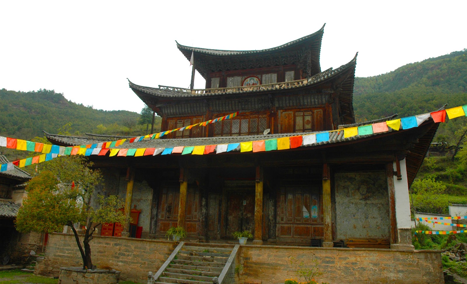
        Strings of prayer flags span the lanes leading to the temple, which sits above the back end of the village.  Unusually, it faces west, towards the Biluo Mountains and Tibet itself.  The temple is an elegant old redwood building, with three tiers and gray tiled roofs.  The top tier was added in the mid-Qing Dynasty and elegantly carved posts support the four corners of the roof. 
Bhairab wall mural outside the entrance
       The building has not been renovated since and while some of the exterior color decoration has faded, the carvings on the brackets, of animals and vegetation, are in good condition.  A wall mural of the fierce deity Bhairab near the entry door is mostly intact. And the rows of diamond vignettes of religious symbols that fill the space under the roof at the entrance are unscathed by time.
       In contrast to the muted tones of the exterior, inside the temple is a whirl of color.  Long tubular pendants, covered with flaps of different bright colors, drop down from the ceiling.  New thangkas (religious paintings) and long, narrow pennants hang from the brackets.  Most of the wall murals, generally featuring forms of Bhairab, have been repainted, though a few original, partly faded sections remain.  Gilded bronze statues of Buddha, Avalokitesvar, Padmapani and Tara decorate the altar area. 
       Like the thangkas, these look like recent works and probably donations from outside the immediate area, since there are no nearby Tibetan villages.  From eight to ten monks and novices live there and the village is very religious-minded.  That’s not surprising, since the four different nationalities that live there do so because of their common faith.  Shouguosi monks are very proud of their temple and their tradition and welcome the rare visitor with tea and a khada—ceremonial white scarf.
central market square of Yezhi, old yamen on the right
       Views from around here, and glimpses west through openings in the forest cover on the way back down to the riverside road, reveal steep gorges and high mountains with large swathes of woodlands.  Weixi County still enjoys 36% forest cover, giving it a rich variety of biological resources.  Besides being home to such rare animals as the takin, clouded leopard, pangolin, red goral, golden cat and the snub-nosed monkey, the province’s official mascot, the forests abound in medicinal herbs and plants, edible wild fungi and ornamental flowers like orchids.  Weixi city hosts a trade fair every year to market the county’s medicinal plants, drawing buyers from across the province and beyond.
       Just past the turnoff up to Shouguosi, the road passes between high cliffs that squeeze the river and turn it into raging rapids comparable to those on the Nu River over the Biluo Mountains.  Then a few km later the landscape changes.  The mountains on the east bank stand further away from the river.  A broad tableland spreads out down from their gentle slopes and the town of Yezhi lies at the end of it, just above the river.
Naxi at the Yezhi shops
       A bi-lingual sign at the southern entrance identifies Yezhi as the “Hometown of Lisu Culture.”  Actually, like Kangpu 16 km south, it is mainly a Naxi town and the most impressive old building in the town center is the original Qing Dynasty administrative residence (yamen) of the former Naxi chieftain.  Not in use today, it stands next to the central market square. 
       Naxi women in Yezhi dress very much like those in Lijiang County, minus the ‘seven-starred cape:’ side=fastened jacket in maroon, blue or black, plain trousers and a long black apron.  Occasionally Lisu women turn up in town, usually in modern clothes, but recognizable by their fringed white shoulder bags.  The next village north of Yezhi, on the west bank, is also Naxi, but the settlements above the river, on the edges of high ridges and the slopes of the western mountains, are all Lisu.
       In the 1930s the Morses, an American Protestant missionary family, set up a base in Yezhi.  For several years they evangelized among the then poor, downtrodden, exploited Lisu villages and had great success.  Eventually they moved on to Gongshan County in Nujiang, with similar results, until forced to flee to Burma in 1949.  Today most Lisu in western Weixi County are Christian.
Lisu village near Yezhi
Naxi woman in Yezhi
       Perhaps that’s why they don’t favor their full ethnic outfit for everyday wear anymore.  Some missionary groups sought to eradicate the custom because it pre-dated the arrival of the Word of God.  The Morses’ sect did not make such demands, but at any rate the Weixi Lisu did not abandon it completely.  They still don it for the big Christian festivals, for while Christianity is part of their tradition now, so is their original Lisu identity.

the Lancangjiang in Weixi County
                                                                   * * *   
               for more on the Tibetans in Yunnan, see my e-book Living in Shangrila
                           on the Naxi, see my e-book Children of the Jade Dragon