Monday, October 22, 2018

The Other Side of the Azure Mountains—Shaxi to Xiaguan


                                   by Jim Goodman

outskirts of Shaxi, on the Heihui RIver 
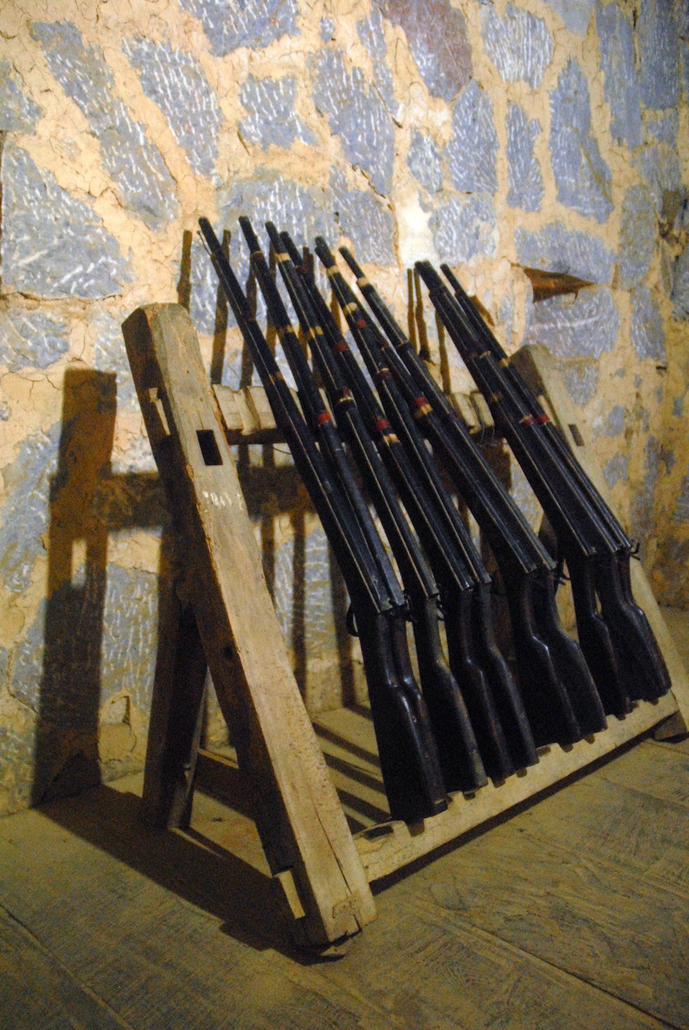
       Before highways began linking up various parts of Yunnan in the 20th century, and trucks started delivering goods everywhere, caravans were the means to carry out long-distance trade.  While they plied over trails on traditional routes connecting all parts of the province, one of the most important was the famous Tea and Horses Road, running from Xishuangbanna in the south, through western and northwestern Yunnan and into Tibet.  Its name derived from its principal trade items—Pu’er tea from southern Yunnan and horses from Tibet.
       Many towns along the route became popular stopovers for the caravans, providing lodging and places to tether their animals.  Among these was Shaxi, in Jianchuan County, northern Dali Prefecture.  The usual way to get there was proceeding north of Xiaguan, at the south end of Erhai Lake, with the Azure Mountains (Cangshan in Chinese) on the west side, then passing out of the valley, through Eryuan County and to Sword Lake, just south of Jianchuan city. 
Yi woman crossing the old stone bridge
typical Shaxi old town lane
the old theater on the market square
      At the junction here a road turns ssw along the Heihui River, which empties into Sword Lake, and soon enters a broad plain dominated by the town of Shaxi.  Never very big, it was nevertheless fairly prosperous until the virtual end of the caravan trade after 1949.  Yet in its slow modernization over the next several decades, Shaxi still retained its old quarter of cobbled lanes and traditional Bai houses, former lodges for the caravan operators and dilapidated, but not destroyed, temples and other public buildings.  It was the last of the caravan stopovers that still looked like one.
       Shaxi is basically a farmers’ town, but from the beginning of the 21st century it took on a new identity as a popular tourist attraction.  The provincial government launched restoration programs, renovating the old temples and the theater on the market square and promoting its historic connection to the Tea and Horses Road.  The town has a new section of boring concrete buildings, but it is a minor part of Shaxi and such architecture doesn’t appear in the traditional quarters.  New houses have gone up, but in classic traditional Bai style.
Shaxi Friday market
Bai women run stalls on market day
      The town sits on the west bank of the river and a little above the water.  Two bridges cross the Heihui.  One is for pedestrians, centuries old, a classic arched stone bridge with sculpted lion heads at each end and on the side over the highest point of the arch.  The other, for vehicles, is an ordinary level bridge in the 1950s style, with elliptical arches and plain columns at each end.  It looks out of synch with all the old-fashioned buildings within sight in every direction.  But at least it is outside the town proper, where the traditional look has not only survived, but has been enhanced.
Bai woman in Shaxi
Yi woman in Shaxi
       The population is mixed Han, Hui and Bai.  Most of the houses are mud brick with tiled roofs.  Others, like the former boarding houses, are manly wooden.  Some of the richer Bai live in houses with carved gates, more use of stone, and painted decorations under the apex of the roofs like those in Dali or Jianchuan.  Shade trees line the main streets in the old town and trimmed shrubs sit in pots in front of the houses.  Passageways through the lanes pass under the arches of neighborhood gates or of houses that straddle both sides of the lane.
ancient sculptures in a Shibaoshan grotto
       A quiet, almost sedate atmosphere prevails in the old town, where vehicular traffic is basically absent, except for bicycles and the occasional tractor-trailer.  That all changes on Friday, Shaxi’s market day.  Residents of the town, joined by villagers from the vicinity, set up stalls in the old market square and along practically all the lanes in the old town.  The local dentist has an outdoor stall that day, too. 
       Products on sale vary considerably.   One section will feature carved doors and windows, chairs and stools, another all kinds of carrying baskets, yet another tools and horse trappings.  One lane will fill with grains, spices, vegetables and fruits and the next one will offer shoes and clothing.  There will be noodle stalls for those who want lunch and steamed buns and other snacks available at small stands.
stone vagina, Shibaoshan
camel head rock, Shibaoshan
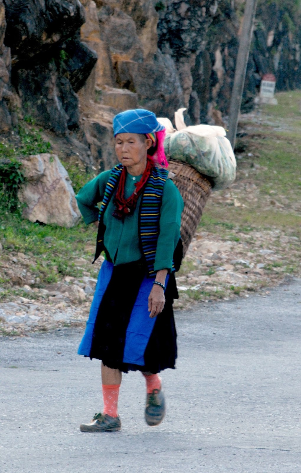
       Market day draws the valley’s Han and Bai, but also many Yi from the mountains, as well as a few Lisu, Naxi and perhaps itinerant Tibetans selling medicinal herbs.  The Yi are the same Nuosu branch that dominates Ninglang County.  Yi women are the most colorful people in the market, with long, bright, tri-colored skirts, decorative jackets and wearing either a large black rectangular hat or a flat, embroidered cloth held in place by hair braids.  And if it’s cool weather, the outfit includes a dark felted woolen cape.
Shaxi countryside
       In late afternoon, when villagers start returning home, leading ponies packed with their goods, the scene evokes the time of the Tea and Horses Road.  The caravan trade expanded from the 10th century during the Song Dynasty, for the latter needed the horses to deal with enemies on its northern frontiers.   Shaxi may have been a caravan stopover by then, though no relics exist from that long ago.
       Nearby Shibaoshan, however, is the site of religious monuments from the Nanzhao Kingdom, with stone carvings from around 800.  Shibaoshan is a tall, steep hill in a wooded rural area, remarkable for the pagodas built into its cliffs and the grottos with stone sculptures.  These date from the Nanzhao and Dali periods before the 13th century.  They include a seated Buddha flanked by his two favorite disciples, a standing Guan Yin, various multi-armed guardian deities and small Buddha images.
       The most unusual is a stone vagina.  Local women come here, especially when they get pregnant, to pray and to rub the stone.  They believe this act will ease the pangs of childbirth.  Shibaoshan is also host to the three-day Bai Singing Festival at the end of the 7th lunar month.
Bai woman in Changyi
Yi woman in Changyi
       In the caravan heyday Shaxi was a stopover for groups on the way to and from Tibet.  Merchants might also pick up salt here from nearby mines.  Going south, they needn’t detour to Eryuan and Dali to reach Xiaguan, but could simply continue down the valley of the Heihui River over what used to be called the Bonan Road.  The road is never very high above the river, nor does it cross any hills.  Villages are visible in the flanking hills and all along the riverbanks.
the old mosque in Yangbi
       The road passes through western Eryuan County and the last village before entering Yangbi County is Changyi, which holds its market day Saturday.  Bai and Yi, as in Shaxi, are the main participants.  Except for furniture, most items on sale are the same as in Shaxi, with the exception of walnuts, a specialty of Yangbi County.
      Yangbi is a Yi Autonomous County, with at least four Yi sub-groups living in the hills, which make up most of its territory.  Until a generation ago the Yi lived at a level of basic subsistence.  Then the government introduced the planting of walnut trees.  Yangbi is not the only place in Yunnan cultivating walnuts.  Dayao and Gongshan Counties also have them, for example.  But the soil in Yangbi seemed to be particularly good for walnuts, producing a thin-shelled, tasty, slightly sweet nut, and soon Yangbi became dubbed the “hometown of walnuts.”
Yunlong Bridge, Yangbi
       Nowadays walnut plantations cover 71,000 hectares in the county.  The annual output has reached 50,000 tons, valued at one billion yuan.  Government statistics claim that as a result 70% of the county’s population has been lifted out of poverty.  Harvesting begins in September and to coincide with it the county government stages a month-long Walnut Festival in Yangbi city.  Events include rites to the Walnut God, food-tasting events (and not just walnuts), cooking competition, markets and rounds of singing and dancing performances.
       As the road crosses into Yangbi County the towering peaks of the Azure Mountains rise to the east.  In the caravan era Yangbi city, originally called Shangjie, was an important junction on the Bonan Road.  Instead of going on to Xiaguan or north to Shaxi, caravans could turn west here to Yongping and Baoshan.  The city has a modern section of nondescript concrete and steel buildings around the city stadium, the main venue for festivals.  But it also has an extensive old quarter, largely Hui-inhabited, full of traditional tile-roofed wooden houses.  A fine old Chinese-style mosque sits on a mound above the old neighborhood.
Yangbi old town
Stone Gate Pass behind Jinniu
       Homes are not as elegant as some of the Shaxi dwellings and the cobbled lanes have not been renovated in recent years.  But a walk through it is evocative of an earlier era.  Continuing past the mosque, the lane terminates at the old Yunlong Bridge, the main river crossing for caravans going west.  A suspension bridge with wooden planks laid across iron cables, dating from the early Qing Dynasty, it doesn’t have caravan traffic anymore, but is still in use by villagers living across the river.  On the other side, earlier this century Yangbi Han Buddhists erected a small Buddhist shrine and a pagoda above it.
Xi'er River in Xiaguan
       From Yangbi city the road swings southeast along the river, in this county renamed the Yangbi River, until its confluence at Pingpo with the Xi’er River that flows east to Xiaguan and into Erhai Lake.  The road swerves much closer to the Azure Mountains on this stretch and at Jinniu is a steep cleft in the hills called Stone Gate Pass, now being built up as a scenic attraction with the construction of a walkway along the base of one of the cliffs.  At Pingpo the road turns east along the Xi’er River, passes the southern end of the Cangshan range and glides into Xiaguan.
       Now the capital of Dali Prefecture and the biggest city in western Yunnan, Xiaguan began as an 8th century fortified settlement, founded by King Piluoge of the new state of Nanzhao, to guard the southern entrance to the Dali plain.  Taihe, further north, established in 737, served as the Nanzhao capital until it was moved to Dali in 779.  Xiaguan lies at the southwest corner of Erhai Lake, backed by high mountains with its suburbs sprawling into the foothills.
Nanzhao warriors on a fresco at the General's Temple
       Over time it outgrew Dali and was a major stop for caravans heading north on the Tea and Horses Road to Tibet, as well as the Southwest Silk Route to Dehong Prefecture and on to Burma and India.  By the turn of the 20th century it was also a major tea-processing center.  Its commercial importance increased with the construction of the Burma Road during the Sino-Japanese War to enable the transport of supplies of all kinds from British-held Burma to Yunnan.
       After the war and the foundation of the People’s Republic, Xiaguan’s growth and development expanded.  New industries appeared such as power generation, food processing, papermaking, cigarettes, cement and marble processing and polishing.  The factories are scattered, though, and not concentrated in one polluted area.  The Xi’er River runs through the city center and residents sometimes come to fish with poles from the walkways on the banks or with nets cast from rafts or boats they take out on the water.  A few parks lie along the river and a very large and well-developed one occupies a long offshore island on the lake.
the General's Temple, Xiaguan
       Xiaguan does not feature the old buildings, monuments and relics that characterize Dali or Weishan.  It does, however, have a pair of sites associated with Nanzhao’s history.  On a hill in the western suburbs stands the General’s Temple, dedicated to General Li Mi, who is not a local hero but instead was a Tang Dynasty commander of a huge Chinese invasion force in the mid-8th century.  This was the third attempt by Tang China to subdue Nanzhao and, like the previous two, it ended in total disaster.  Li Mi lost his entire army and in the end drowned himself.
       The victors gave the dead a proper funeral and interred the corpses, or maybe the ashes, inside a tomb in Tianbao Park, in what is now the western quarter of the city.  It’s just a stone mound with some exterior inscriptions and probably never contained as many remains as the records claimed.  But it’s Xiaguan’s only true Nanzhao relic.
       Many generations after Li Mi’s demise, his descendants established a shrine to his memory and to invoke his protection of the area.  In the Ming Dynasty a three-part temple replaced the original shrine.  Nowadays many local Bai devotees come here to make offerings, especially at the mid-autumn festival, Li Mi’s birthday.  Considering that the Bai were, along with the Yi, the victors over Li Mi’s army, it seems odd that they would be making offerings to him.  But Bai country folk are devout by nature and upbringing and may not even be aware of the historical particulars regarding the object of their worship.  To them, he’s a protective deity and that’s enough.

Yangbi old town and valley
                                                                        * * *
 Delta Tours Vietnam arranges a journey through western Yunnan that includes a stop in Shaxi.  For the itinerary see https://www.deltatoursvietnam.com/western-yunnan       


Sunday, October 7, 2018

Making the Đồng Vân Circuit—the Northern Tip of Vietnam


                                                                           by Jim Goodman

Đồng Văn and its majestic setting
       The northeast border province of Hà Giang has always been one of the most remote parts of Vietnam.  Mountains cover most of its nearly 8000 km2 area and only in the last decade have good, all-weather roads been constructed linking its capital Hà Giang City with Hanoi, 320 km south, and other towns in the province.  Agriculture and forestry account for most of the economic activity.  While the province is rich in mineral resources—antimony, iron ore, zinc, manganese, copper tin, gold, bauxite and gemstones—these remain underexploited. 
the old market in Đồng Văn
       It is still a poor province, in terms of services, hospitals and the general standard of living in the rural areas.  Yet its population of around 730,000 is by no means destitute.  Those residing in the towns, mostly Vietnamese and some Ty, live moderately well and those in the highlands—Hmông, Dao and other minorities—enjoy basic self-sufficiency.  Travelers are unlikely to encounter malnutrition or dire poverty.
       Hà Giang is also one of the country’s most beautiful provinces.  Its four northernmost districts—Qun B, Yên Minh, Mèo Vc and Đng Văn—make up the UNESCO-recognized Đng Văn Karst Plateau Geopark.  Of its 2300 km2, limestone accounts for 80% of the surface, usually in the form of mountains up to 2400 meters, with some of it consisting of boulders that jut up from farmlands in the valleys.
Đồng Văn farms
       Rocks in this landscape contain fossils dating back 400-600 million years.  Excavators have also found stone tools made by early human settlers 10,000-30,000 years ago.  At the Sì Phài Pass above Đng Văn a stone inscription marks the spot as the site of one of the five biggest sudden mass extinctions in the history of the bio-world.  Due to climate changes, a fall in the sea level and changes in the composition of sea water, 33^ of marine fauna families disappeared.
Hmông village at Mã Pí Lèng
       In the recent past it could take at least three days to go from Hanoi all the way to Đng Văn.  Nowadays, leaving Hanoi in the morning, travelers can reach Đng Văn, 146 km further north of Hà Giang City, in the early evening.  The town’s stunning location is in a narrow oval plain at 1100 meters altitude, backed by high hills that flank the rice fields adjacent to the urban area.  Some farms lie on the slopes with more moderate gradients, but many of the hills are too steep for cultivation.
       In the town center is the old market square, marked by a large sculpture of a reed-pipe, a cultural symbol of the Hmông minority, the dominant ethnic group in the hills..  The new market is down a lane across the street and is especially active on Sunday, Đng Văn’s market day, when ethnic minorities from the hills stream into the town.  Many hotels and restaurants are in this area, while on the main street local folks set up convivial evening stalls offering cups of corn liquor and various grilled snacks.
Nho Quê River at Mã Pí Lèng
karst landscape near Mã Pí Lèng
       In colonial times Đng Văn was too remote to attract French settlers.  It did have a military base, though.  Behind the southwest suburbs stands a tall, steep hill where the French built a lookout post and fort called Đn Cao.  Only the ruins of its walls survive, but visitors can take the path up to it for a splendid view of the valley.
Mèo Vạc
       The French first arrived in the area in 1886, following victory in the Sino-French War, fought over the issue of which nation would control northern Vietnam.  As they tried to extend control they faced a revolt by the Dao minority in 1901.  They quickly quelled the uprising, then made an alliance with the district’s de facto ruler Vương Chính Đức, a Hmông lord whose family had been commissioned by the Nguyễn Dynasty to administer the district.  Now he would rule on behalf of the French and helped them put down another revolt, by the Dao and their allies, that lasted from 1913-1915.
White Hmông girls in traditional clothes
       In the vicinity of Đn Cao a road turns right and immediately ascends into the mountains and heads south 21 km to Mèo Vc, with fabulous scenery all the way.  This is the beginning of the Đng Văn circuit and after about ten kilometers the road reaches the Hmông settlement at Mã Pí Lèng Pass, just above the canyon of the Nho Quê River.  The view here is the best on the route, looking across to myriad shapes of jagged peaks and steep, nearly vertical slopes.
       The village sprawls below a high hill, the land much studded with rocks.  Small patches for grain and vegetables lie between.  It’s too high and the soil too stony for rice cultivation, so the main crop is corn, which grows wellhere.  People use it to feed themselves and their animals, turn a portion of it into liquor and use the husks and stalks as fuel.
elderly Dao Tá Pàn woman
Hmông woman in the Lũng Phìn market
       The villagers belong to the White Hmông branch and are not as colorful as the various Flowery Hmông groups to their west.  Men dress in modern style and women wear knee-length, pleated skirts of a great variety of colors and patterns which mostly come from Chinese textile factories.  They may wear traditional leg wrappers and side-fastened jackets, but exhibit no sense of uniformity in the complete outfit.  Nevertheless, they are still recognizably Hmông, for no other ethnic group dresses like this.
Lũng Phìn market day
       The Hmông, lik their linguistic cousins the Dao, migrated to this area two to three centuries ago.  The plains and valleys were already occupied, so they had to settle in the mountains, with its rocky slopes, stony ground and less productive soil.  But that’s been a theme of Hmông history, always pushed out of good land by stronger neighbors and forced to make a living on the lands nobody else wanted.  Yet they succeeded, extracting the maximum from what was available for them.
       From Mã Pí Lèng the road continues high above the Nho Quê River and begins descending about five kilometers before Mèo Vc.  This town is about the same size as Đng Văn, though its enclosing hills are a little further away.  Ordinarily it’s a quiet place, except for Sunday, also Mèo Vc’s market day, with lots of hill people in and around the central covered market.
Dao woman in Lũng Phìn
Hmông girl in Lũng Phìn
       At the junction just outside of Mèo Vc, one road turns southeast towards Bo Lc, in Cao Bng province, and the other heads west to Yên Minh, 50 km distant.  The landscape is not as dramatic as that above the Nho Quê River, but it’s a pleasant ride through rolling, forested hills.  The biggest villages along the way are Sung Tra, about six km from Mèo Vc, and Lũng Phìn, another twenty km or so further.  Sung Tra holds its market day on Saturday, while Lũng Phìn hosts it on the tiger and monkey days of the 12-day animal cycle.
the road to Yên Minh
       Market days are the other prime attraction, besides the scenery, of the Karst Geopark districts.  Moreover, they are enjoyable on cloudy, misty days, when the scenery is barely visible.  Most foreigners confine their market day experience to Sundays, at Đng Văn and Mèo Vc.  The former starts very early, while the latter isn’t active until very late morning.  The other venues see few foreigners and are without any souvenir stalls catering to tourists. 
       Lũng Phìn’s market is especially attractive.  The village lies on the south side of the road and where its main street meets the highway the commercial activity is at its most congested.  All along the main street, which rises slightly uphill, Hmông and Dao women set up their stalls, on up to the covered market building at the top.  The Hmông here outnumber the Dao, and dress similarly to those around Mã Pí Lèng. Some of the younger ones don white skirts or very spangled blouses and lots of ornaments.
rich farm manor near Lũng Cú
      The Dao belong to the Tá Pàn sub-group and their women wear long coats, split at the sides, with embroidered strips running vertically down the front, fastened by rectangular silver buckles.  They also wear trousers that look plain black when they stand still.  But when they walk, or a breeze comes along while they are standing, the heavily embroidered patterns on the sides become visible.  Older women wear large black turbans, middle-aged ones wear round caps and the unmarried go hatless.
Lũng Cụ flag tower
       Past Lũng Phìn, the road continues across rolling hills, occasionally swerving around huge black granite boulders jutting up from the fields.  At Yên Minh it turns north and begins climbing into the mountains again.  After 20 km it comes to a junction.  The way left goes five km to a closed valley and the border post village of Phó Bng.  A right turn goes west back to Đng Văn.  Several km past the junction stands another big sculptured Hmông reed-pipe.  The road turning north here runs along high hills and then reaches Lũng Cú, a small town with its rice fields lying at the bases of a cluster of hills.
       Lũng Cú’s claim to fame is its position at the northernmost point of Vietnam, just below the Tropic of Cancer line.  On a hill on the northern side of town stands a flag tower, and from here one can have a view into southeastern Yunnan, China.  There’s not much to see in that direction but wild mountains, but the view down to the village and town layout and its farms is worth the excursion.
       Returning to the road junction with the reed-pipe, just a little further west is the next major stop.  This is the Hmông village of Sà Phìn.  It holds market day on snake and pig days, drawing mainly local and neighboring White Hmông.  It’s also the location of the Vương Palace, which sits in a wooded area outside the village. 
part of the Vương family palace
       After sealing their alliance with Vương Chính Đức, the French hired Chinese architects to build him a palace in 1902-03.  Comprising four two-story wooden buildings, separated by courtyards and surrounded by a white-plastered brick wall, the palace, now a museum, is the primary historical attraction in the area.  Side rooms in each quadrangular compound serve as exhibits of household items when the palace was in use.  These include the elegant furniture of the study, the family altar, the kitchen with its twin brick fireplace, the family altar, a wooden mortar for pounding corn, a vertical loom, thread-winder and spinning wheel, and an armory with a rack of  old rifles.
       For assistance in suppressing the 1913 revolt, for sending soldiers to the French garrison in Hà Giang City, and for keeping order in his domain, the French promoted Vương Chính Đức to General in 1927.  In the following decade, however, he became sympathetic to the anti-colonial resistance and after the Japanese occupied northern Vietnam in 1940, he began supplying covert assistance to the Việt Minh.  
the Vương family dining room
       He died in 1944, but his son and successor Vương Chính Sính pledged support to Hồ Chí Minh and helped enable the Việt Minh capture of Hà Giang City in March 1945.  After 1954 he donated his land to the provincial government and served it as the representative of Đồng Văn, Mèo Vạc and Yên Minh districts.  He died in 1966 and the palace became a school.  In recent decades a new school was erected below the palace, which then became a museum.
       The road back to Đồng Văn remains high in the hills most of the way, allowing many scenic views, especially on the slow descent to the city. The best time of year to visit is the autumn, when the fields are yellow with the ripening rice crop.  But winter is never very cold, as it rarely snows, even in the mountains, while during the summer it doesn’t rain continuously and the fields are bright green.  Planting takes place in mid-spring, but this is also the time of the area’s most interesting annual event—the Khâu Vai Love Market.
old rifles in the Vương palace
Hmông woman on the road above Đông Văn
       Khâu Vai holds a regular market day every five days beginning with the 2nd day of the lunar month.  But on the 26th-27th days of the 3rd lunar month it hosts the Love Market.  Unmarried young people may attend any ordinary market day with their eyes open for a potential partner, but this Love Market actually marks the opportunity for ex-lovers to meet again.  It originated long ago in an affair between a Giáy girl and a Nùng boy.  Opposition from Giáy elders led to a war between the two ethnic communities and the couple decided to terminate the relationship in the interests of peace.  But they arranged to meet once a year at Khâu Vai and since then the custom spread amongst other ex-lovers and became the Love Market Festival. 
       Besides former lovers, the popular event attracts a broad range of ethnic minorities in the area, dressed in their best, enjoying a variety of activities and entertainment.  And like the fabulous karst landscape, it is unique to the northern tip of Vietnam.

farms behind Đồng Văn 
                                                                             * * * 
Delta Tours Vietnam can make arrangements to visit Đồng Văn and other destinations in Hà Giang province.  See https://www.deltatoursvietnam.com/other-tour-options