
by Jim Goodman
 |
| Đồng Văn and its majestic setting |
The northeast border province
of Hà Giang has always been one of the most remote parts of Vietnam. Mountains cover most of its nearly 8000
km2 area and only in the last decade have good, all-weather roads been
constructed linking its capital Hà Giang City with Hanoi, 320 km south, and
other towns in the province.
Agriculture and forestry account for most of the economic activity. While the province is rich in mineral resources—antimony,
iron ore, zinc, manganese, copper tin, gold, bauxite and gemstones—these remain
underexploited.
 |
| the old market in Đồng Văn |
It is still a poor province,
in terms of services, hospitals and the general standard of living in the rural
areas. Yet its population of
around 730,000 is by no means destitute.
Those residing in the towns, mostly Vietnamese and some Tảy,
live moderately well and those in the highlands—Hmông, Dao and other
minorities—enjoy basic self-sufficiency.
Travelers are unlikely to encounter malnutrition or dire poverty.
Hà Giang is also one of the
country’s most beautiful provinces. Its four northernmost districts—Quản Bạ,
Yên Minh, Mèo Vạc and Đồng Văn—make up the
UNESCO-recognized Đồng Văn Karst Plateau Geopark. Of its 2300 km2, limestone accounts for
80% of the surface, usually in the form of mountains up to 2400 meters, with
some of it consisting of boulders that jut up from farmlands in the valleys.
 |
| Đồng Văn farms |
Rocks in this landscape
contain fossils dating back 400-600 million years. Excavators have also found stone tools made by early human
settlers 10,000-30,000 years ago.
At the Sì Phài Pass above Đồng Văn a stone inscription
marks the spot as the site of one of the five biggest sudden mass extinctions
in the history of the bio-world.
Due to climate changes, a fall in the sea level and changes in the
composition of sea water, 33^ of marine fauna families disappeared.
 |
| Hmông village at Mã Pí Lèng |
In the recent past it could
take at least three days to go from Hanoi all the way to Đồng
Văn. Nowadays, leaving Hanoi in
the morning, travelers can reach Đồng Văn, 146 km further north of
Hà Giang City, in the early evening. The town’s stunning location is in a narrow oval plain at
1100 meters altitude, backed by high hills that flank the rice fields adjacent
to the urban area. Some farms lie on
the slopes with more moderate gradients, but many of the hills are too steep
for cultivation.
In the town center is the old
market square, marked by a large sculpture of a reed-pipe, a cultural symbol of
the Hmông minority, the dominant ethnic group in the hills.. The new market is down a lane across
the street and is especially active on Sunday, Đồng Văn’s market day, when
ethnic minorities from the hills stream into the town. Many hotels and restaurants are in this
area, while on the main street local folks set up convivial evening stalls
offering cups of corn liquor and various grilled snacks.
 |
| Nho Quê River at Mã Pí Lèng |
 |
| karst landscape near Mã Pí Lèng |
In colonial times Đồng
Văn was too remote to attract French settlers. It did have a military base, though. Behind the southwest suburbs stands a
tall, steep hill where the French built a lookout post and fort called Đồn
Cao. Only the ruins of its walls
survive, but visitors can take the path up to it for a splendid view of the
valley.
 |
| Mèo Vạc |
The French first arrived in
the area in 1886, following victory in the Sino-French War, fought over the
issue of which nation would control northern Vietnam. As they tried to extend control they
faced a revolt by the Dao minority in 1901. They quickly quelled the uprising, then made an alliance with
the district’s de facto ruler Vương Chính Đức, a Hmông lord whose
family had been commissioned by the Nguyễn Dynasty to administer the
district. Now he would rule on
behalf of the French and helped them put down another revolt, by the Dao and
their allies, that lasted from 1913-1915.
 |
| White Hmông girls in traditional clothes |
In the vicinity of Đồn
Cao a road turns right and immediately ascends into the mountains and heads
south 21 km to Mèo Vạc, with fabulous scenery all the way. This is the beginning of the Đồng
Văn circuit and after about ten kilometers the road reaches the Hmông
settlement at Mã Pí Lèng Pass, just above the canyon of the Nho Quê River. The view here is the best on the route,
looking across to myriad shapes of jagged peaks and steep, nearly vertical
slopes.
The village sprawls below a
high hill, the land much studded with rocks. Small patches for grain and vegetables lie between. It’s too high and the soil too stony
for rice cultivation, so the main crop is corn, which grows wellhere. People use it to feed themselves and
their animals, turn a portion of it into liquor and use the husks and stalks as
fuel.
 |
| elderly Dao Tá Pàn woman |
 |
| Hmông woman in the Lũng Phìn market |
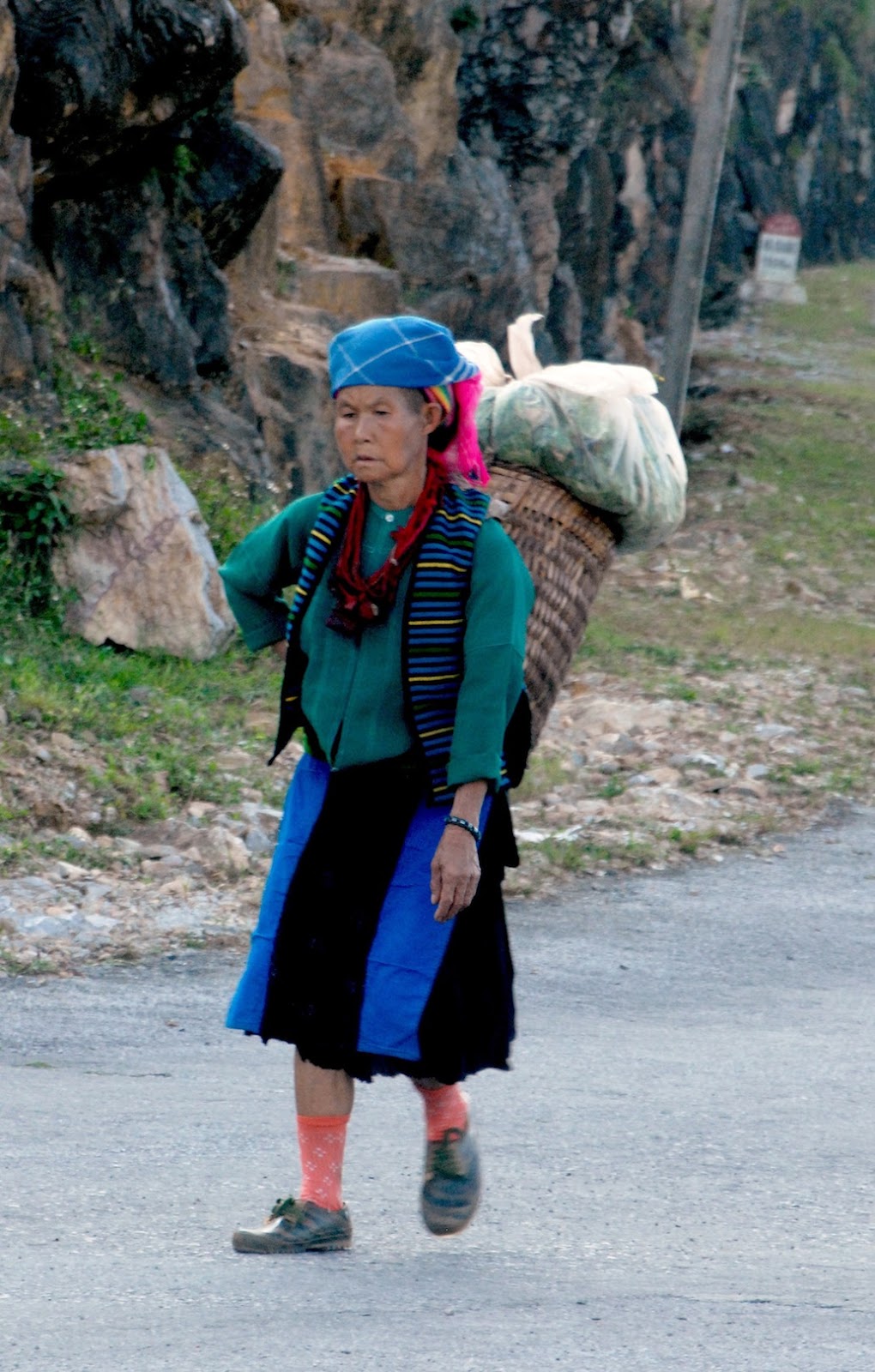
The villagers belong to the
White Hmông branch and are not as colorful as the various Flowery Hmông groups
to their west. Men dress in modern
style and women wear knee-length, pleated skirts of a great variety of colors
and patterns which mostly come from Chinese textile factories. They may wear traditional leg wrappers
and side-fastened jackets, but exhibit no sense of uniformity in the complete
outfit. Nevertheless, they are
still recognizably Hmông, for no other ethnic group dresses like this.
 |
| Lũng Phìn market day |
The Hmông, lik their
linguistic cousins the Dao, migrated to this area two to three centuries
ago. The plains and valleys were
already occupied, so they had to settle in the mountains, with its rocky
slopes, stony ground and less productive soil. But that’s been a theme of Hmông history, always pushed out
of good land by stronger neighbors and forced to make a living on the lands
nobody else wanted. Yet they
succeeded, extracting the maximum from what was available for them.
From Mã Pí Lèng
the road continues high above the Nho Quê River and begins descending about
five kilometers before Mèo Vạc. This town is about the same size as Đồng Văn,
though its enclosing hills are a little further away. Ordinarily it’s a quiet place, except for Sunday, also Mèo Vạc’s
market day, with lots of hill people in and around the central covered market.
 |
| Dao woman in Lũng Phìn |
 |
| Hmông girl in Lũng Phìn |
At the junction just outside
of Mèo Vạc,
one road turns southeast towards Bảo Lạc, in Cao Bằng
province, and the other heads west to Yên Minh, 50 km distant. The landscape is not as dramatic as
that above the Nho Quê River, but it’s a pleasant ride through rolling,
forested hills. The biggest
villages along the way are Sung Tra, about six km from Mèo Vạc,
and Lũng Phìn, another twenty km or so further. Sung Tra holds its market day on Saturday, while Lũng Phìn
hosts it on the tiger and monkey days of the 12-day animal cycle.
 |
| the road to Yên Minh |
Market days are the other
prime attraction, besides the scenery, of the Karst Geopark districts. Moreover, they are enjoyable on cloudy,
misty days, when the scenery is barely visible. Most foreigners confine their market day experience to
Sundays, at Đồng Văn and Mèo Vạc. The former starts very early, while the latter isn’t active
until very late morning. The other
venues see few foreigners and are without any souvenir stalls catering to
tourists.
Lũng Phìn’s market is
especially attractive. The village
lies on the south side of the road and where its main street meets the highway
the commercial activity is at its most congested. All along the main street, which rises slightly uphill,
Hmông and Dao women set up their stalls, on up to the covered market building
at the top. The Hmông here
outnumber the Dao, and dress similarly to those around Mã Pí Lèng. Some of the
younger ones don white skirts or very spangled blouses and lots of ornaments.
 |
| rich farm manor near Lũng Cú |
 |
| Lũng Cụ flag tower |
Past Lũng Phìn, the road
continues across rolling hills, occasionally swerving around huge black granite
boulders jutting up from the fields.
At Yên Minh it turns north and begins climbing into the mountains
again. After 20 km it comes to a
junction. The way left goes five
km to a closed valley and the border post village of Phó Bảng. A right turn goes west back to Đồng
Văn. Several km past the junction
stands another big sculptured Hmông reed-pipe. The road turning north here runs along high hills and then
reaches Lũng Cú, a small town with its rice fields lying at the bases of a
cluster of hills.
Lũng Cú’s claim to fame is its
position at the northernmost point of Vietnam, just below the Tropic of Cancer
line. On a hill on the northern
side of town stands a flag tower, and from here one can have a view into
southeastern Yunnan, China. There’s
not much to see in that direction but wild mountains, but the view down to the
village and town layout and its farms is worth the excursion.
Returning to the road junction
with the reed-pipe, just a little further west is the next major stop. This is the Hmông village of Sà Phìn. It holds market day on snake and pig
days, drawing mainly local and neighboring White Hmông. It’s also the location of the Vương
Palace, which sits in a wooded area outside the village.
 |
| part of the Vương family palace |
After sealing their alliance
with Vương Chính Đức, the French hired Chinese architects to build him a palace
in 1902-03. Comprising four
two-story wooden buildings, separated by courtyards and surrounded by a
white-plastered brick wall, the palace, now a museum, is the primary historical
attraction in the area. Side rooms
in each quadrangular compound serve as exhibits of household items when the
palace was in use. These include the
elegant furniture of the study, the family altar, the kitchen with its twin
brick fireplace, the family altar, a wooden mortar for pounding corn, a
vertical loom, thread-winder and spinning wheel, and an armory with a rack
of old rifles.
For assistance in suppressing
the 1913 revolt, for sending soldiers to the French garrison in Hà Giang City,
and for keeping order in his domain, the French promoted Vương Chính Đức to
General in 1927. In the following
decade, however, he became sympathetic to the anti-colonial resistance and
after the Japanese occupied northern Vietnam in 1940, he began supplying covert
assistance to the Việt Minh.
 |
| the Vương family dining room |
He died in 1944, but his son
and successor Vương Chính Sính pledged support to Hồ Chí Minh and helped enable
the Việt Minh capture of Hà Giang City in March 1945. After 1954 he donated his land to the provincial government
and served it as the representative of Đồng Văn, Mèo Vạc and Yên Minh
districts. He died in 1966 and the
palace became a school. In recent
decades a new school was erected below the palace, which then became a museum.
The road back to Đồng Văn
remains high in the hills most of the way, allowing many scenic views,
especially on the slow descent to the city. The best time of year to visit is
the autumn, when the fields are yellow with the ripening rice crop. But winter is never very cold, as it
rarely snows, even in the mountains, while during the summer it doesn’t rain
continuously and the fields are bright green. Planting takes place in mid-spring, but this is also the
time of the area’s most interesting annual event—the Khâu Vai Love Market.
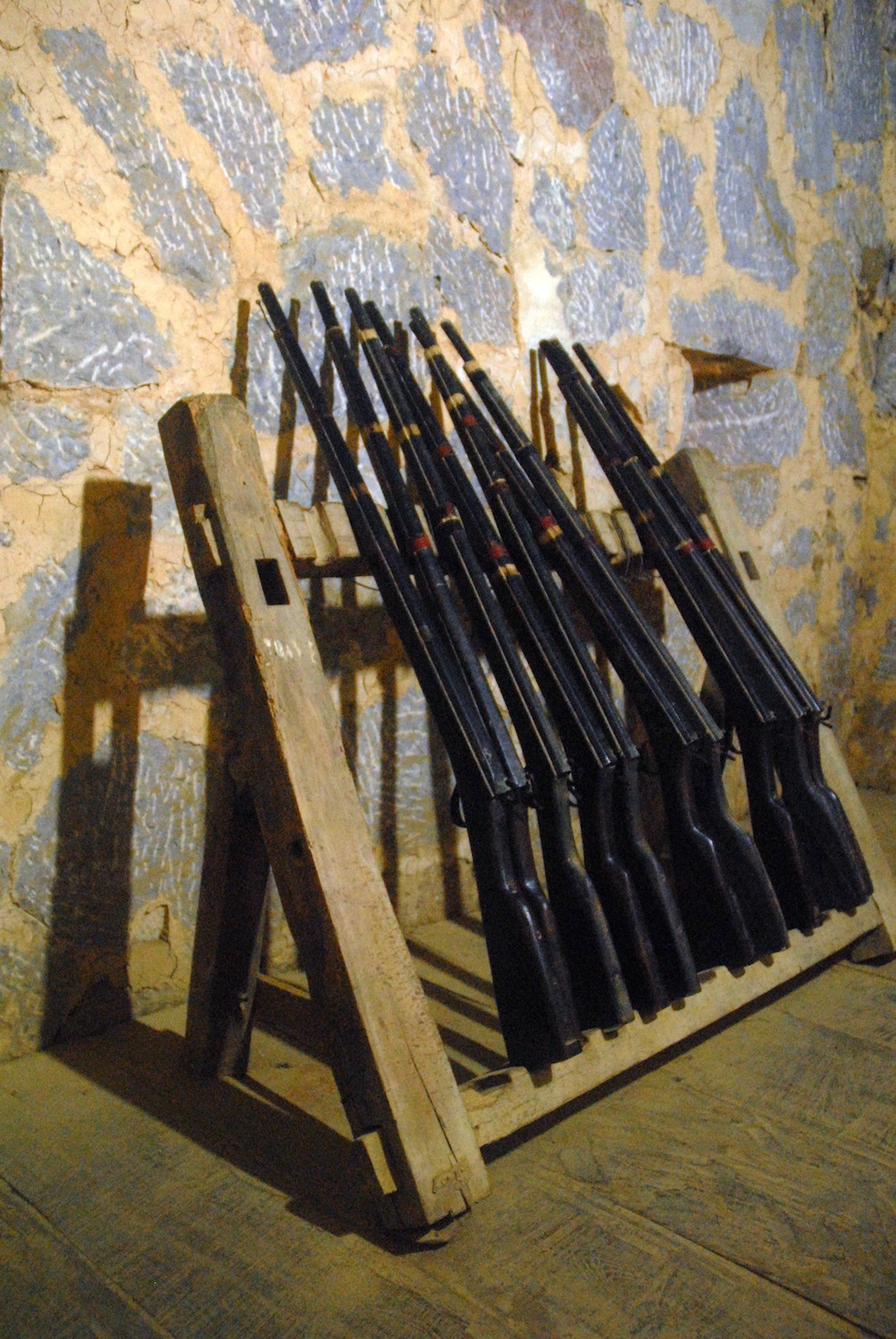 |
| old rifles in the Vương palace |
 |
| Hmông woman on the road above Đông Văn |
Khâu Vai holds a regular
market day every five days beginning with the 2nd day of the lunar
month. But on the 26th-27th
days of the 3rd lunar month it hosts the Love Market. Unmarried young people may attend any
ordinary market day with their eyes open for a potential partner, but this Love
Market actually marks the opportunity for ex-lovers to meet again. It originated long ago in an affair
between a Giáy girl and a Nùng boy.
Opposition from Giáy elders led to a war between the two ethnic
communities and the couple decided to terminate the relationship in the
interests of peace. But they arranged
to meet once a year at Khâu Vai and since then the custom spread amongst other
ex-lovers and became the Love Market Festival.
Besides former lovers, the popular
event attracts a broad range of ethnic minorities in the area, dressed in their
best, enjoying a variety of activities and entertainment. And like the fabulous karst landscape,
it is unique to the northern tip of Vietnam.
 |
| farms behind Đồng Văn |
*
* *
Delta Tours Vietnam can make arrangements to visit Đồng Văn and
other destinations in Hà Giang province.
See https://www.deltatoursvietnam.com/other-tour-options
No comments:
Post a Comment