Showing posts with label Luliang. Show all posts

Monday, January 15, 2018

Qujing to Zhaotong: a Look at Northeast Yunnan


                                    by Jim Goodman

Qujing's reconstructed ancient gate
       Throughout the 90s I made repeated excursions to Yunnan province, fascinated everywhere I went.  By the end of the decade the only area I hadn’t visited was the northeast-- Qujing and Zhaotong prefectures.  Little information was available, for neither place drew tourists in significant numbers.  Those looking for something different from the ordinary Yunnan itinerary might venture to the Colored Sand Forest or the Duoyi River area, home to the Buyi minority, both in Qujing.  Zhaotong was only a stopover for those coming to Yunnan from Sichuan or Guizhou.    
       A new highway has opened in 1999, so the journey from Kunming only took two hours.  Qujing lies on one of the broadest plains in Yunnan and is the province’s second largest city, after Kunming.  The prefecture was one of the earliest settlement zones for Han immigrants, even long before the Ming Dynasty officially sponsored migration. 
Ashima and Ahei statue
       The city was clean and well laid out, but nearly every building was new and in modern style.  No traditional neighborhood of wooden shop-houses flanked the business district, as in Yuxi and Kunming.  The residents seemed to be all Han and I spotted several old-fashioned elderly women wearing turbans, embroidered bibs, plain aprons and embroidered shoes.   Some attempt had been made to give the city a Chinese look, with traditional pavilions and bridges in the parks and the impressive recreation of the South Gate, erected in the mid-90s. 
the park at  historic Liaokuoshan
       The gate, with its massive, two-tiered tower, stood at what was then the southern city limit, in a park decorated with flower gardens and fountain and flanked by a stream.  The wall extends about 40 meters each side of the entrance, with watchtowers at each end.  At night, lights illuminated the fountain and gate.
       The main east-west street—Qilinlu—is named after the city’s mythical mascot the unicorn (qilin).  In fact, the city is more commonly referred to by residents as Qilin.  At the eastern roundabout stands a statue of the Unicorn Fairy, holding a pitcher of pouring water.  Further up, at the western roundabout, was a statue of the Sani Yi heroine Ashima, riding a horse with her brother Ahei behind, using his bow and arrow against the enemy. 
Meng Huo and Zhuge Liang toasting their agreement
       For me this was an odd statue to see, being familiar with the Sani story already.  Both figures wore the faces of grim and resolute determination, very much in the old socialist-realist style. According to the myth, the two were actually fleeing in terror from a demon chief who had tried to abduct Ashima.  He subsequently used his magic power to thrust up the stone pillars of the Stone Forest and then sent a flood through it to drown her and her brother.  And anyway, that all happened in an area far from Qujing and no Sani Yi lived in the prefecture. 
       While its connections to the famous Sani myth are suspect, Qujing historically was the site of two important events in Chinese history, both taking place in Baishijiang, just north of the city.  In the 3rd century Three Kingdoms wars, upon the death of the western state of Shu Han’s leader Liu Bei in 223, revolts broke out in Nanzhong, corresponding to today’s southern Sichuan and most of Yunnan.  Shu Han’s chancellor Zhuge Liang, led his Southern Expedition to quell the revolt, but in a manner that would win the hearts and minds of the people.
Duoyihe RIver and village
Buyi girl near Duoyihe
       His final opponent was the popular tribal leader Meng Huo.  According to legend, and the 14th century Three Kingdoms novel, six times Zhuge Liang captured Meng Huo, but when the latter refused to admit defeat, he let him go and try again.  On the seventh capture Meng Huo submitted.  The victor offered him palatable terms.  Meng Huo acknowledged Shu Han’s sovereignty and agreed to send regular tribute.  In return, he remained in charge of internal affairs.  This was the forerunner to the modern policy of autonomous areas in areas dominated by non-Han peoples.
Jinji Peaks in Luoping County
       A broad stone relief sculpture of the event stands at Baishijiang today.  The central panel depicts Zhuge Liang and Menghuo toasting their agreement.  Other panels render scenes of Shu Han troops, bull fights and other Yi customs.
       Over a millennium later, the Ming Dynasty launched a campaign in 1381 to expel the remnant Yuan Dynasty forces from Yunnan, their last refuge in China.  Dispatching 300,000 Han and Hui troops against the Mongol and local Hui forces, the final battle in January 1382 took place on the same field at Baishijiang.   The Ming side annihilated its opponents.  The last Yuan survivors held out briefly at Liaokuoshan, a wooded hill that is  now the city’s largest and finest park, outside the southwest corner of the city, for just a few days longer. That was the end of Yuan resistance and the hill’s name translates as Peak of Victory.
Jiulong Waterfalls, Luoping Coiunty
       No memorial of any kind exists around Baishijiang commemorating this event, which marked the final triumph of the Ming Dynasty over all of China.  Two relics of earlier periods, however, in the form of inscribed stone steles, stand in pavilions in the courtyard of the No. 1 Middle School.  The earlier, dated 404, is famed for its calligraphy, supposedly a transition from the ancient style to the contemporary.  The other, erected by the King of Dali in 937, records details of the state’s eastern expedition and lists its tribal allies.
Qianfota, Luliang
       Among its natural features, Qujing Prefecture is the site of the origin of the Pearl River, 47 km north of the capital in Luyi County.  The source is a spring, the waters directed into the Huashan reservoir.  It wasn’t very impressive, but other places in the prefecture, particularly Luoping County in the southeast, certainly are.  The most extensive scenic area is near the junction of Yunnan, Guizhou and Guangxi provinces, marked by steep limestone mountains, with one range named the Sea of Ten Thousand Forested Peaks.  The lovely Duoyi River valley lies near here, with its numerous water-wheels and friendly Buyi ethnic minority and the Lubu artificial lake, created by filling in a gorge.
       About 12 km east of Luoping is the county’s most famous natural attraction—the Jinji Peaks, a broad cluster of small hills dotting the plain south of the highway.  They are not very tall, averaging 200 meters, nor irregular in shape.  But spaced close to each other over a wide and utterly flat plain they make an appealing sight, especially in February and March when the canola flowers (also called rapeseed flowers) carpet the plain in bright yellow.  Hordes of tourists show up to photograph the landscape.  
central Zhaotong, 1999
       After another 20 km or so the highway comes to a junction turning north.  After a route through pleasant rural scenery several km this branch road terminates at Jiulong Waterfalls, the widest and most visited falls in the province.  The cataracts spill over two broad ledges about 8-10 meters high and perhaps 20 meters apart.  Forested hills provide the backdrop.
       A different kind of mountain attraction exists west of Luoping, in Shizong County.  Lying 30 km from the county seat, it’s called Mushroom Mountain after the abundance of edible mushrooms growing there, especially in rainy season.  In the center of Shizong itself stands the White Pagoda, with nine tiers and a column of dark, arched windows on each of its eight sides.  In the western suburbs lies the Xihua Temple, a large complex of buildings originally constructed in 1610.
traditional-style Han in Zhaotong
Miao herbal doctor in Zhaotong
       The next city west, Luliang, had some quiet, old-style neighborhoods with tree-lined streets and wooden shop-houses back then. In the southern suburbs is the Dajiao Temple, a Ming Dynasty compound erected four years after Shizong's Xihuasi.  The temple itself is a modestly decorated building.  But the compound contains one of Yunnan's most interesting pagodas--the Thousand Buddha Pagoda (Qianfota).   Seven stories tall on a hexagonal base and pale yellow-white in color, the pagoda gets its name because of the thousand square niches on its exterior walls, each of them containing a small Buddha image.
Zhaotong old town, 1999
       To get to Zhaotong from Qujing I traveled via Weining in Guizhou, with a stop at Xuanwei en route.  Lishan, at 2678 meters the highest mountain in Qujing Prefecture, towers just north of the city.  Xuanwei was famous for its ham, but not interesting otherwise.  Neither was Weining and its cement buildings and much of it under construction.   Weining is a Yi, Hui and Miao Autonomous County, but I didn’t see anyone dressed in clothing associated with any of the three, neither in the city nor on the road out to Zhaotong next day.
       After the boring streets of Xuanwei and Weining, I found Zhaotong a pleasant city.  At that time the southern and western quarters were all modernized, but traditional architecture, markets and lifestyle still dominated the northern and eastern quarters.  The city had a strong Hui presence, indicated by the mosque standing above the neighborhood houses at the southeast entrance to the city.  A tall sculpture of a black-necked crane, the city mascot, stood on a pedestal near the man bus station.
basket shop in the old town
       The former old town, little of which remains, comprised wooden shop-houses down narrow lanes, brick and tile private dwellings, shops selling the whole range of split bamboo handicrafts, from furniture to winnowing trays, or ceramic vessels.  Though the buildings lacked the carved embellishments once replete in Kunming's old town, they did create a setting of Old China.  Traffic was largely pedestrian, plus some three-wheeled pedicabs with bright yellow frames and fenders.  The traditional feel of the area was augmented by the old-fashioned clothing style favored by the older generations of the Han--women in big turbans, side-fastened jackets and long aprons; men in ankle-length, side-fastened coats, slit on the sides, with long wispy beards on their chins.  They were the only ones in town dressed in traditional style, save for a few Miao women marketing herbal medicines and Hui women in white headscarves.
old houses in Zhaotong,1999
       The old town and new city meet in the north at the Qingguanting Park.  Just inside the entrance is the modest but attractive Qingguan Pavilion, of gray brick and red wood, beside a big tree next to a small pond.  It was built in 1809 and is the one  major historical structure extant in the city.  A stream from this pond passes into an adjacent park under an arched bridge to a larger pond, with a long pavilion and rest-house beside it. 
       Most of the prefecture’s population is Han, both in the towns and the countryside.  Besides the Hui in the towns and in some plains villages, the more mountainous districts are home to Yi and Miao.  They are not as colorful as their counterparts elsewhere in the province and have assimilated much to modern Han culture.  Most Miao and some Yi became Christian after vigorous American missionary efforts in the Nationalist period.  Coincidentally, at that time the province was under the control of Long Yun, a Yi warlord born in Zhaotong.
Qingguan Pavilion, Shaotong
       North of the city the mountains rise quite steeply.  Having time for but one excursion I opted for Daguan, 63 km north.  But that was the year new roads were under construction all over Yunnan and the normal route to Daguan was closed.  My ride instead was a long bumpy, 170 km detour via Yilong Country, then east and north again and finally, 12 hours later, I arrived in Daguan.  The city is on a spur beside a river, but 300 steep meters above it.  No parks or old quarter existed, but the location was superb, backed by high mountains, the slopes studded with Miao villages.
       The reason to be in Daguan was to see the Huanglian Falls, several km south of the town and a wonderful morning walk with views of steep, majestic, jagged mountains all around.  Paths in the park led in several directions among the different cataracts.  A few of these tumble from high precipices.  Others seem to have been artificially directed, like the one that passes over a ledge where one can walk and see the waterfall from the inside.  Another path leads to a cave with three elephant statues at the entrance and illuminated stalactites within.  One path leads to a viewpoint high above the cataracts, while another branches off to the Miao villages.  The area is thickly forested and full of flowers in the spring.
terrcaed cataract of Huanlian falls
Huanglian Falls and its forest
     
Following this pleasure I took an overnight bus back to Kunming, over the same slow, grueling detour.  Our early morning stop was somewhere in northern Qujing Prefecture.  Before me stretched a landscape of relatively barren auburn hills and rich reddish soil freshly plowed in the nearest fields.  It was not the best place to see this Yunnan phenomenon, yet a reminder of other attractions in northeast Yunnan.  There were still scenic spots and ethnic minority districts I had not yet visited.  As with every other part of Yunnan, a first look just provoked ambitions to see more.

red soil landscape in northwest Qujing
                                                                    *  * * 


Monday, December 5, 2016

The Beauty of Erosion


                                               by Jim Goodman

garden and pillars near the hotel in the Little Stone Forest
       Known for its ethnic diversity, with 24 minority nationalities spread across its territories, many of them with numerous distinct sub-groups, Yunnan also has the greatest geographical variety of any province in China.  It doesn’t have a seacoast, though a beach at the northern end of Fuxian Lake can provide a similar summer experience.  Nor does it have a proper desert, just extremely dry areas here and there where scarcely any vegetation grows.  But it has everything else, from low-lying tropical plains in the south to snow mountains in the northwest cresting over 6000 meters and every possible rugged landscape in between.
       Much of the present topography of Yunnan is due to its geological history, especially the disruptions of the Permian Age, some 270 million years ago.  Violent activity beneath the earth’s crust thrust mountains up to spear the skies, raised lake beds above their water level and drained the inland seas.  Eons later, the seismic activity has still not stopped.  Almost annually, major earthquakes wreck havoc in various parts of Yunnan, rearranging the landscape just like civilized man and his development projects.
limestone projections in the Stone FOrest
       Some of the Permian permutations occurred in places where the original inland seabed was limestone.  This is a sedimentary rock composed of marine elements like mollusk, coral and other creatures.  When exposed to rain, the water slowly but surely dissolves parts of the surface, creates fissures to seep through, sometimes all the way through the rock.  The process carves the rocks into new, irregular and unique shapes of hills, boulders, caves and pillars, creating a phenomenon known as karst landscape.
pillars in the Stone Forest
       The word comes from the Karst Plateau on the Istrian Peninsula, mostly in Slovenia, where the first scientific studies were carried out.  It means “place where rocks are exposed to the air.”  Karst landscapes, including subterranean examples, exist in many places throughout the world.  In this region the best known are in Guangxi Province, along the Li River from Guilin to Yangshuo, and Hạ Long Bay in Vietnam, where the hills appear as islands speckling the sea.
       Yunnan’s karst rival to these sites is the Stone Forest, just two hours east of the capital Kunming.  It is not Yunnan’s only karst landscape, for others exist at Puzhehei, Babao and Duoyihe.  But in those locations the hills may have a bald cliff on one side, but are generally green with some kind of shrubs or plants at the least.  The formations in the Stone Forest are mostly pure, barren rock, usually silver gray.
       When I first visited Yunnan in the early 90s, the Stone Forest was the most heavily advertised tourist attraction.  Every hotel pushed tours there.  As it was also the homeland of the Sani people, a branch of the Yi nationality, I considered it an appropriate introduction to Yunnan’s two prime attractions—ethnic and natural.  But in those days tourists did it in a day-trip, arriving about 10 to 11 in the morning and leaving by 2:30 so they could have an early dinner back in Kunming. 
Dashilin--the Big Stone Forest
       This left the park virtually empty of visitors early morning and late afternoon, the best times for photography anyway.  So I opted to stay overnight inside the park, get out early and explore before the first tour buses arrived.  Just for the adventure, I took the train to Yiliang, which sometimes rose high above the highway for better countryside views.  But buses from Yiliang were not frequent then and, after a lunch in a restaurant, my traveling companions, a European teacher couple on holiday from Beijing, decided to hire a cab to take us there.
       We arrived just before dark, sped through the entrance gate where the ticket booth was already closed and managed to have our dinner just as the Sani dance show was about to begin.  People tend to disparage minority dance shows in Yunnan as exploitation for the tourist business.  I was seated from where I could see the performers off-stage, awaiting their turn and practicing their steps one last time before they went on.  They obviously took it seriously themselves.  In fact, ethnic minority dances have been part of Yunnan’s tradition of welcoming guests since the Nanzhao Dynasty over a thousand years ago.  A Yunnan minority troupe even resided in the Tang Dynasty capital of Chengdu at that time.
dog-like stone in Shilin
       We set out early, though the skies were nearly covered with clouds the whole morning.  Xiaoshilin, the Little Stone Forest, lay near the hotel and features a small lake and some of the tallest, most evocative pillars, including the one named after the Sani heroine Ashima.  Dashilin, the Big Stone Forest, a little further on, sprawls over a much larger area, with pathways that wind through, around and sometimes under the boulders. 
       Time and erosion have sculpted some of these stones into arresting and suggestive shapes, like a dog howling at the moon, or the one called Camel Riding an Elephant.  The path sometimes veers out of one conglomeration of boulders to a field flanked by yet another ‘grove’ of bare rocks jutting out three to six meters above the ground.  The sides of many have parallel vertical ridges like the exterior of a loofah gourd, the surface smooth in between the ridges.  Groups of boulders or pillars may also have horizontal crack lines across their sides, as if they came from a celestial giant’s building block set, or were being prepared as water channels for the invisible demons that prowl the ‘forest’ at night.
flat-topped pillars in the Sand Forest
       It was still overcast when we departed, Just as the park was fast filling with tourists.  I returned the following year in good weather to photograph everything again, this time staying in a lodge just outside the entrance, this time paying the 20 yuan entry fee, and again starting my exploration just as the crowds were leaving.  Since the mid-90s the ticket price has jumped nearly ten times that and so has the number of visitors.  It must be the most financially lucrative tourist spot in Yunnan.
       Smaller concentrations of karst topography lie all over Shilin County’s rolling hills.  The most notable are on the outskirts of Suogeyi village and in Naigu Shilin, the Black Stone Forest, where the rocks are mostly charcoal black instead of steel-gray.  For a very different kind of eroded attraction one goes to Luliang County, east of Shilin, and the Colored Sand Forest (Caise Shalin), 18 km south of Luliang city, at the foot of Wufeng Mountain.. 
wall sculpture in a Shalin cave
the 'scholar' rock
       Here it’s not limestone, but sand mixed with stone, with a high quartz content.  Rather than a near-uniform gray, rock formations come in a variety of colors: rust-red, light orange, white, yellow, light gray and pink, sometimes several in one group, which is why it got its name.  Tall, thin pillars like those in Shilin stand here, too, but most of the formations are thicker pillars with very even flat tops that almost look like they were sawed off.  They may stand in groups among the trees at the lower end of a steep cliff.  Or they could be lined up in descending heights.  Occasionally they can be egg-shaped or triangular, with an anthropomorphic cliff face, like the one resembling a scholar with a pointed cap.  Or they might have accessible caves, where ancient monks lived in retreat and in one case carved a deity’s face on the wall.
cliffs in the Colored Sand Forest
     
When I visited Shalin two decades ago it was a pleasant contrast to the commercial hubbub around the Stone Forest.  Though it was a nice day I was practically alone in the park, often wondering why it wasn’t crowded.  From March 2001 that changed dramatically with the inauguration of the annual International Sand Sculpture Festival, in which artists from across the globe come to create sculptures out of the grounds of the park.
       That gave the Colored Sand Forest nationwide publicity and the 21st century wave of domestic tourists began including Shalin on their Yunnan itineraries.  Conscious of its reputation for uniquely colored sands, local vendors began bottling them to sell to tourists.  Then tourists started bringing their own bottles and went out on the trails to chip away at boulders and cliff sides to collect free souvenirs. 
like a row of buildings in the Earth Forest
       A number of violent storms and a more acidic precipitation in recent years have also contributed to the accelerated rate of erosion.  The formations in the Sand Forest are intrinsically not as strong as limestone.  Combined with the tourist poaching, half of the park’s formations have disappeared or severely deteriorated.  In some cases souvenir excavations along the base of a cliff have helped make it slide onto the ground.
       Some of the intact scenic areas have been declared off limits as a result, while workers have installed black retaining walls in the park’s main 6km2 walking area to bolster the weakened cliffs.  Park workers also make daily tours looking for fresh holes to plug.  While the area still has its breathtaking attractions, the Colored Sand Forest is becoming a sad example of how tourism can instigate erosion far faster than natural forces like wind and rain.
the Earth Forest in Yuanmou County
       A third phenomenon of natural erosion in Yunnan suffers neither from pilfering nor vast crowds.  Called Tulin, the Earth Forest, it covers 50 km2 of an area 36 km northwest of Yuanmou, which is itself 200 km west of Kunming.  Thus it is too far for a day-trip and only likely to be part of a schedule for Yunnan visitors in the province who are here for an extended time.  I myself wound up seeing it in the mid-90s as an excursion out of Yongren, prior to an all-night bus ride back to Kunming. 
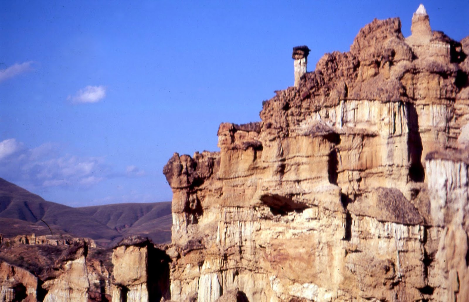
       After turning off the main road north of Yuanmou, we passed through a rural area full of trees and streams before reaching Banguo, the village beside the park.  Entering the area just beyond the village the landscape suddenly changed.  The groves were gone.  The stream beds were dry and the view in front of me more approximated that of a desert.   High, dry, vertical cliffs lined the stream bed in subdued colors of pale yellow to light red-brown.  Some vegetation sprouted on small ledges along the cliff faces, but scarcely any trees were visible except on the hills in the distance, glimpsed in between sections of the cliffs.
cliffs and pillars in the Earth Forest
       There was no ticket booth back then and the only manmade addition to the park, besides a smattering of signposts along the bridle trail, was a flower tree garden just inside the entrance.  Villagers offered me a pony ride, which would have been a good idea to reach the furthest parts of the park, but I really only had time for the nearest section and, felling fairly vigorous after the ride from Yongren, decided to walk.  As the afternoon wore on and the light was less intense, the colors on the cliffs and pillars became ever richer and more enchanting.  
chedi-like spires in the Earth Forest
                Compared to the Stone Forest and Colored Sand Forest, the Earth Forest is relatively young.   Geologists reckon its age as 1.5 to 2 million years.  The soil here is sand rock mixed with clay.  Movements of the earth’s crust caused crannies in the soil that deepened and widened over the eons.   Besides the cliffs that rise so sharply from the plain, the Earth Forest features pillars that rise like columns up to forty meters high. 
       A walk through the Earth Forest easily stimulates one’s imagination.  Protrusions on the sides of the cliffs can resemble high-relief carvings of animals like rabbits, gophers and crouching lions.  Some of the pillars are topped with narrowing spires that look like Southeast Asian Buddhist temple chedis.  Other pillars have lateral extensions at the top like horse heads on their upturned necks.
       Other cliffs suggest urban architecture.  Cliffs in a row, a little apart from each other, stand like high-rise city buildings.  Some spots on the high cliff walls, sculpted by time and weather, appear to be rocked-carved cathedrals, with doors, windows and triangular roofs.  Others are like palaces with columned front facades.
       The Earth Forest does not have an annual sculpture festival.  There’s a ticket booth now, 100 yuan admission, and tours are a bit more organized, with vehicles instead of ponies.  But it draws nowhere near the crowds of the Stone Forest and encompasses a larger area.  There are still plenty of places in the Earth Forest where one can be alone in contemplation of an inspiring landscape, and define its details in similes and metaphors, just like the classic Chinese poets.

'buildings' carved by time in the Earth Forest
                                                                    * * *