Showing posts with label World Heritage Sites. Show all posts

Sunday, December 29, 2019

Bagan’s Sea of Pagodas


                                      by Jim Goodman

Shwesandaw and Dhammayan Gyi
       For a country long used to negative reports in the international media, this year Myanmar drew the world’s attention for a very felicitous reason.  On 6 July 2019 UNESCO recognized the ancient capital of Bagan as a World Heritage Site.  It was a long time coming.  Myanmar’s government had first nominated Bagan for the award in 1995.  But Myanmar was a pariah country then, under the military-led State Law and Order Restoration Council (the notorious SLORC).  Western governments discouraged their citizens from making it a tourist destination.  And members of the UNESCO committee objected to some of the restoration work.
the gilded stupa of Shwezigon
       Time passed.  Eventually a civilian government came to power.  Tourist arrivals have been burgeoning for at least fifteen years, with Bagan one of the most popular excursions.  Despite the original qualms, UNESCO could no longer deny the site its due recognition. 
       It certainly deserved it.  The Bagan Archaeological Zone, with over 3000 pagodas and temples, comprises 104 square kilometers, making it the world’s largest.  Founded in the mid- to late 9th century, capital of the country’s first Burmese Empire from 1044-1287, the plain around it once held over 10,000 religious monuments.  Bagan’s religious tradition followed that of their Pyu predecessors, a Tibeto-Burman people occupying several city-states in the Ayerewady Valley, heavily influenced by their trade links with India.  It encompassed both Theravada and Mahayana Buddhism, plus Tantra, Hindu cults of Shiva and Vishnu, as well as the indigenous spirit (nat) beliefs.
stupas on the way to New Bagan
      Wars with its neighbor Nanzhao, in contemporary Yunnan, China, from 750-830, destroyed Pyu political power.  In this power vacuum rose the Kingdom of Bagan, founded by Burmese people (Bahmar), who would by two centuries later extend their control over the whole Irrawaddy Valley and its periphery.  Under King Anawrahta, who ascended in 1044, the state became an empire.  He extended the rice cultivation area, especially to the east, with weirs and canals, which encouraged the immigration of ever more farmers.  He made Theravada Buddhism the state religion, though tolerated other beliefs, and sponsored the formation of a script for the Burmese language.
Thatbinniyu (right), the tallest pagoda on the plain
      His able successors Kyinsuttha (1081-1112), who patronized Mon scholars and artisans, and Alaungsithi ·1112-1167), who constructed more irrigation systems and standardized weights and measures, presided over a long period of peace and prosperity.  The empire had no real rivals and grew quite wealthy.  And with both kings and commoners religiously pious, much of that wealth became devoted to building temples and pagodas.  Their palaces, houses and walls have disappeared, but their spectacular array of religious monuments remains as a legacy that draws visitors from all over the world.
pagodas on the Bagan plain
       People can fly to Bagan’s airport, but a more interesting way there is to go by boat from Mandalay, to the north.  The fastest boat takes about eight hours, though one could take cheaper, slower ones that arrive well after dark, or even the next morning.  The journey by road also takes the entire day and is basically a boring succession of farms and villages.  The river route can also be tedious for long stretches, but at least one can walk around on deck and enjoy food and drinks.
sunrise view from Shwesandaw
       After departing Mandalay in early morning, the boat soon passes slowly by the former medieval capital Sagaing.  The town lies on the west bank and morning light from the east on the two long, temple-studded hills that make up the town keeps the passengers’ cameras clicking.  After Sagaing the scenery is monotonous until the junction with the Chindwin River, and then relatively boring again until just before the landing at Bagan, where the northernmost stupas are first visible.
       I made the trip on a sunny day in December 2006.  The monsoon had ended less than two months previously but already the river was rather shallow.  The boat zigzagged its way downriver to avoid getting stuck on a sandbar.  It made brief stops at a village south of Sagaing, where children waded out from shore to sell bananas and other snacks, and at the confluence with the Chindwin, where a few passengers disembarked.  Until approaching Bagan scarcely any other vessels were in the river, with a surprising dearth of fishing activity.
Sulamani Temple

      The boat pulled into the pier at Old Bagan next to Bupaya Temple, reputedly the oldest monument in the city.  Unfortunately, a devastating earthquake of 6.3 magnitude in1975 completely leveled the building and what stands there now is a reconstruction.  Most of the main temples remained standing, though some lost a few spires.  Bagan suffered periodic earthquakes throughout its history and it’s a tribute to the skills of the planners and architects that so many major temples and pagodas survived them relatively intact.
       Reconstruction commenced soon afterwards and by 2006 even the smaller temples and stupas had all been restored.  Some had plaques placed in front listing the names of those who sponsored the restoration and others had newly installed Buddha images.  Because they used new bricks it was easy to tell which spires or other parts had been damaged and some were completely rebuilt from the base up.
typical bell-shaped stupa
       We arrived late in the afternoon when the waning light enriched the colors of the monuments, enhancing the 40-minute hike to New Bagan, where I stayed in a moderately priced hotel for four nights.  Clusters of pagodas along the way gave me a foretaste of what to expect come morning.  Rich visitors stayed in luxury hotels in Old Bagan and backpackers headed for cheap guesthouses in Nyaungthu village.  But wherever one lodged, wonderful temples and pagodas were just a short walk away.
gilded stupa atop Dhammayazika
      For the most majestic view of the archaeological zone one could take an expensive balloon ride over the plain.  The government had also erected a 60-meter-tall viewing tower on the northern side. Most people were content to explore the area on foot, by bicycle or by pony-cart.  I did all three.  About a dozen temples have interior staircases enabling visitors to reach the upper levels, provided you can find the groundskeeper to unlock the door. 
       A notable exception is Shwesandaw, southeast of Old Bagan, which has exterior stairways on three sides, with handrails.  It’s the most popular spot to watch the sun set behind the mountains west of the river.  Perhaps because guests did not want to miss the free morning breakfast in their hotels, hardly anyone showed up for the sunrise, which I found even more enchanting.
severed Buddha head on the ground
stone carving on a temple facade
       Climbing up to the fifth level of this whitewashed temple and looking west I could see groups of pagodas at intervals, with the distant mountains in the background.  The nearest cluster stood about a hundred meters away.  The first sun rays bathed the fronts of the buildings, while wispy, low, skinny clouds lay between the trees in nearby groves.  When the sun rose higher, the clouds dissipated and it was time to move on.
stone frieze on Abeyodana Temple
       Scholars divide the buildings into three periods.  The early period, 850-1100, reflects Mon and Pyu influence, with small perforated windows and dark interiors.  The middle period, 1100-1170, features bigger windows, taller stupas and a vertical emphasis.  Those of the late period, 1170-1300, are more elaborate, with more sculptural embellishments.
       The majority of the buildings are individual stupas, both simple small ones and big ornate ones.  The earliest were often cylindrical or like mounds, but from the 11th century the bell shape dominated.  A few are whitewashed, others gilded, but most are of brick.  Some have smaller stupas at the corners of each of the pagoda terraces and some are completely gilded.  All of them are supposed to contain relics, indicating, from the sheer number of such stupas, just how prevalent the collecting and preserving of relics was to the religious-minded people of the Bagan era.
temple and stupas
       Stupas also rise above the tops of the temples, which have extended hollow chambers at the base, generally one or four, used for meditation and rituals.  They may also have large Buddha images from the original construction or smaller, modern ones installed during restoration.  Several temples feature interior frescos.
       UNESCO sponsored restoration of the biggest group, at Abeyodana Temple, mainly Hindu and Mahayana Buddhist imagery, but including lots of secular everyday life activities.  Nandamannya Pahto’s set of Mahayana panels is in less good condition.  Its most famous scene, the Temptation of Mara, with its bare-breasted beauties, is covered with glass and difficult to see.  Those at Ananda Ok Kyaung and Updi Thein depict daily life activities from the 17th-18th centuries, when they were painted.  Frescos in the Kyanzitthi cave temple, 800 years old, are too worn to see well, though they include panels of Mongols.
interior Buddha images
       Compared to the sculptural paradise of Angkor, Bagan doesn’t have many extant carvings.  Here and there one comes across a toppled Buddha head on the ground.  A few stone panels of deities, mythical animals and dancing apsaras exist, like the set at Abeyodana Temple.  A couple others have standing Buddhas or well-worn elephants.  Dhammayazika, with a recently re-gilded spire, has panels of Jataka scenes, stone sculptures around the base and protruding, stone makara-headed drainage pipes on the terrace levels.
       Among the most picturesque temples are three from the early period:  Shwesandaw—the sunrise/sunset viewing favorite, Thatbinniyu—the tallest on the plain, and Ananda Pahto—the biggest and most complex.  All three are whitewashed.  For its 900th anniversary in 1992, Ananda Pahto had its spires gilded  
Manuha Temple, built by a captive Mon king, 11th c.
       Besides Abeyodana and Dhammayazika, other Bagan temples draw much visitor attention.  Sulamani has the most classic shape, with small stupas lining the sides of the multi-tiered base.  Mahabodhi is an exact replica of the ancient one in Bodh Gaya, India, where the Buddha achieved Enlightenment.  Dhammayangyi is the largest in volume, though its spire has toppled.  The Sein Sisters pair are in completely different styles from each other. Seinnyet Nyima resembles a smaller version of Sulamani, while Seinnyet Ama is a large, bell-shaped stupa.
       Bagan reached the zenith of its prestige and power in the late 12th and early 13th centuries, under Kings Narapatyi Sithu (1174-1211) and Htilominlo (1211-1235).  These rulers enlarged the borders, prevented Khmer expansion out of central western Thailand, codified the law, established a standing army and extended Burmese cultural influence beyond its boundaries.  The capital’s population then is estimated as anywhere from 50,000 to 200,000.  Yet this heyday was not to last much longer. 
everyday life in ancient Bagan
       Piety had become a problem.  Kings and nobles granted much of the agricultural land to temples and monasteries, which were exempt from taxation.  Falling revenues meant less money for state administration, especially in the furthest away border provinces, building canals to open new farmland, and equip the army.  The religious spirit, which had inspired so much architectural grandeur, was undermining the state. 
       Conflict began in the south and Bagan lost territory to Arakan and Martaban.  Later in the 13th century Bagan faced Mongol invaders.  While the Mongols apparently never occupied the city itself (they usually destroyed every city they captured), their campaigns successfully terminated Bagan’s power.  By 1287 Bagan’s empire was history and its population reduced to several thousand.  The Myinsaing Kingdom to the south became the pre-eminent state in the country, though neither it nor any of its successors for the next few centuries held sway over Myanmar as much as Bagan had.
UNESCO-restored frescos at Abeyodana
Mahabodhi Temple
       Though it was no longer important politically, Bagan continued to attract pilgrims from all over the country.  They concentrated on Ananda Pahto, Shwezigon, Sulamani, Htilominlo and Dhammayazika.  The other monuments fell into decline.  When the Konbaung Dynasty (1752-1885) took control of Burma, holding territory even greater than the Bagan Empire, its government sponsored many restorations in Bagan, though not necessarily following the originals.  Nevertheless, the ancient site’s prestige, with its importance to Burmese culture, endured. 
Winido Temple, near the viewing tower
       Pilgrims continued to journey to Bagan throughout the colonial period and in the first few decades after independence.  With a slightly improved political situation, tourism began taking off in the 21st century.  It did not draw anywhere near the numbers that visited Cambodia’s Angkor, but it was a less congested, more relaxing experience.  Like Angkor the main sites had their local hawkers, selling souvenirs, bric-a-brac and snacks, plus the ubiquitous painters.  But they were never very persistent.
       In 2006 the entry ticket was a mere US$10, valid for however long you stayed.  Unlike Angkor, where the nearest hotels were in urban Siem Reap, the lodgings were all inside the quiet archaeological zone.  Right after you left your hotel you were in the vicinity of ancient monuments.  You could even walk among them by moonlight.  Many travelers explored the zone on their own.  Groups in buses were not so numerous and didn’t stay long at any particular site, other then the sunset viewing pagodas.
       Visitor numbers have increased since my 2006 excursion, and are likely to grow more now that Bagan is a recognized World Heritage Site.  No doubt more people will be taking the balloon flights over the plain, but the area is too vast to get very congested.  And for an example of what religious fervor can do for architecture, Bagan remains one of the world’s most outstanding,

Seinnyet Nyima and Seinnyet Ama

                                                                        * * *   

Saturday, January 9, 2016

Congratulations, Hani Farmers


                                 by Jim Goodman

Hani village, Yuanyang County
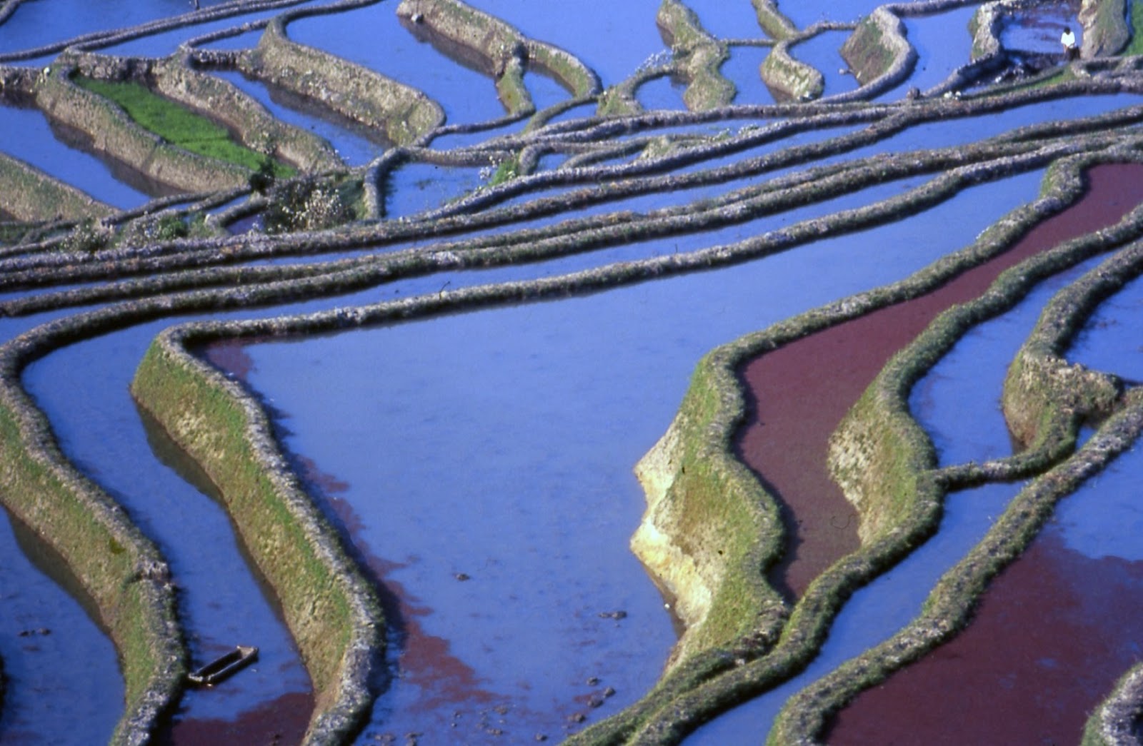
      Every year UNESCO announces new additions to the list of World Heritage Sites.  This year’s selections, revealed in June, included a rather unusual entry—the Honghe Hani Rice Terraces.  Ordinarily World Heritage Sites are spots of outstanding natural beauty, like mountains or canyons, or something manmade, like a magnificent building or an ancient city.   This is one of those rare occasions when contemporary farms made the list.   True, they are very ancient farms, perhaps as old as 1300 years or more, for they are mentioned in Tang Dynasty records.  That makes them older than the famous Inca terraces in the mountains of Peru.  But unlike the latter, long ago abandoned, the Honghe rice terraces have been in continuous use since they were first built.
       Honghe is the name of a prefecture in Yunnan, south of Kunming to the border of Vietnam, comprising several counties north and south of the Red River. Those south of the river are very mountainous and it is the rice terraces here, in the Ailao Mountains, that are so ancient, so beautiful, so amazing, and now becoming internationally recognized for the wonder that they are.  The designated Heritage Site area consists of a large part of southern Yuanyang County, including the stunning section around Panzihua village known as the Tiger’s Mouth.  Farmers here centuries ago cut as many as 3000 terraces into the mountain slopes, from just below the forested hilltops, at around 2000-2500 meters, all the way down to the rivers, lying at around 400 or 500 meters.
terrace irrigation
       While the terrace scenery is particularly impressive in southern Yuanyang County, the same kind of farming system exists throughout the other counties south of the Red River, as well as upriver west of the prefecture as far as Xinping County.  Plenty of other places in Yunnan feature terrace farming, for the province is full of hills and mountains and even the plateaus are more often undulating valleys rather than flat plains.  What makes the Honghe terraces so special is the complex irrigation system established with their initial foundation.  Water flows from terrace to terrace and remains in the fields all year round.
       Farmers only get one crop of rice each year from these farms.  After the conclusion of the harvest work the fields are left full of water until planting time around April.  This is the time the terraces are at their best visually, the water in them reflecting the colors of the sky.  During the dry season the terraces become the abode of ducks, frogs, eels, small fish and snails, which supplement the local diet.  The UNESCO citation takes note of the local “integrated farming system” and states, “The resilient land management system of the rice terraces demonstrates extraordinary harmony between people and their environment, both visually and ecologically, based on traditional and long-standing social and religious structures.”
Hani farmer girl
       They might have added the extraordinary harmony among the people themselves, as well.  And this is precisely because of their land management.  When the Hani ancestors first laid out a village they chose a site near a stream or spring, adjacent to a forest, built their houses there and their rice terraces below the settled area.   The main irrigation stream ran above the set of terraces, with dividers placed at intervals to allow water to spill into the terrace below through notches cut into its wall.  Notches cut in the walls of that terrace allowed water to flow into the one below and so on all the way down to the lowest terrace on the slope.
       Villages had a water guardian whose job it was to keep the main channel free of debris and oversee its renovation after the harvest and to check the dividers to ensure they had not been altered so that someone’s field got more water than what was allotted to them.  This would upset the balance, for the original system, including the position and notches of the dividers, guaranteed that every terrace plot would receive the proper amount of water for the crop.
       It is not clear how they divided up the land, who got the terraces nearest the village and who got the ones far away down the slope.  But all the terraces got the proper amount of water required.  Thus, the economy and society of a village started out on the basis of equality.  As time went on and generations passed this equality did not persist, for in some families more children, i.e. more workers, survived infancy and could contribute to a family’s income.  But the differences in wealth among the people in any given Ailaoshan village were never very great, nor ever resented because they were perceived as due to good luck and diligence and not exploitation, and so a strong sense of village solidarity has persisted over the centuries.
Hani terraces
       This solidarity extends to the entire ethnic group and sub-group and even beyond, as implied in the Hani saying that Yi and Hani are children of the same mother.  Several minority nationalities inhabit the Ailao Mountains—Hani, Yi, Miao, Yao, Zhuang and Dai—and all of them are terrace farmers.  They live in roughly the same manner, with different house types sometimes but with the same kind of material life.  No particular ethnic group ever had power over another and they all lived peacefully with each other, often meeting at the various market day venues.
       Even within the designated World Heritage Site boundaries Yi villages lie scattered over the slopes, with a Miao settlement here and there and Dai in the lower areas.  So it’s a bit inaccurate to make the award to the “Hani rice terraces,” even if they are the majority community in this particular part of the mountains.  The other ethnic minorities are also terrace builders and everything the UNESCO citation praises about the Hani is just as true of the other ethnic communities in Ailaoshan.
       They are all animist societies, venerating spirits associated with forces of nature, the land and their own ancestors, fearing and propitiating troublemaking spirits that could harm them.  They held regular rituals to honor the land spirit or the rice spirit so that nothing would interfere with the cultivation of the rice crop.  Their economy was one of self-sufficiency, though that was more of a goal than a reality, for in general the terraces did not produce enough rice to feed the family all year that tilled it.  In the last weeks before harvest cassavas took the place of rice as the main filler of the meal.
a part of the "Tiger's Mouth"
       The rituals, festivals, even the ethnic styles of clothing all came under sustained attack first in the late 50s and then throughout the tumultuous years of the Cultural Revolution.   After Deng Xiaoping consolidated power such policies ceased once and for all and ethnic culture was now not only tolerated, but also encouraged.  For the Hani and their neighbors, the family responsibility system basically meant a return to the old way of farming.  And since the old way of farming included festivals and rituals to the rice spirit, these revived, too. 
       The one major innovation in their material way of life was the introduction of high-yield rice seeds.  This improved production so much that families could not only grow enough rice to feed themselves the entire year, they very well might even have a little surplus to sell in the market.  Population had gone way up since, say, a century ago, and extra terraces had been made, but now these terraces were producing more rice than at any time in their history.  Traditional material culture had achieved an unprecedented success.
       Besides the magnificent scenery of sculpted mountains, the area’s other main attraction is its ethnic variety.  The Hani are the most numerous of the communities, split into several sub-groups, each with its own distinctive traditional-style women’s clothing.  All the other minorities have at least three sub-groups dressing very differently from each other.  Most of the regular market days in the area witness the presence of several ethnic groups and sub-groups, mainly women, just about all of whom dress in their traditional style clothing.
       These market venues will have stalls with ethnic minority women selling clothing components to other minority women.  There will be Miao stalls selling batik cloth, embroidery thread and Miao jewelry, Hani women hawking Hani women’s jackets, trousers, belts and bags, Yi women offering embroidery and appliqué patterns for blouses and belt ends, etc.  Their customers, of course, will be other Miao, Hani or Yi women who don’t have time to make the items themselves.    
transplanting the rice seedlings
       Now the ethnic revivalism that is so obviously apparent in Ailaoshan has been going on throughout Yunnan for the past generation.  Ethnic festivals have been revived, sometimes with lavish government subsidies, traditional religion has re-emerged and ethnic clothing is popular again, even if only for festivals and other special events.  Definitely ethnic pride has returned.  But nowhere has traditional culture made such a complete comeback as in Ailaoshan.  Elsewhere modern influences have seeped in to the extent that people may be proud of their traditions, but less likely to “revert” to living the traditional way with its antique mind-set.
       The modern influences that are slowly but surely undermining traditional culture elsewhere in Yunnan include basic changes in their material way of life.  A major Hani sub-group, the Aini (elsewhere known as the Akha) in Xishuangbanna and adjacent counties, practiced slash-and-burn agriculture as their traditional way of life.  Due to population pressures, this is no longer viable as a system and so they have largely switched from growing rice to growing tea, rubber or sugar cane, cash crops that they can trade for rice.  However, because they are not growing rice they don’t need to have all those festivals that marked critical points in the rice-growing cycle.  So a big part of their culture disappeared when they changed crops. 
       Other ethnic minorities employing the slash-and-burn method also went through the same changes.  In other areas, with permanent fields, the introduction of modern machinery and fertilizers altered relations between the people and their environment.  In one way or another, in nearly every place in Yunnan, traditional material culture has altered and this has modified other aspects of tradition as well, from religious beliefs to aesthetic views.
Hani on the way to market day
       But Ailaoshan is different.  The material culture has proven its value and so the non-material aspects of tradition have survived to a greater degree than elsewhere in the province.  Festivals have revived because the people still believe in them and the Hani hold several a year.  Villagers have televisions now and are aware of what, for example, people in the outside world wear.  But the women, even the teenaged girls, prefer their own ethnic style because they still retain their traditional aesthetic view.  The most beautiful clothes they can put on, they feel, are their best traditional ones.  They see lots of modern clothing in the markets, but the only items likely to attract their interest are shoes and umbrellas.
       Besides keeping their traditional aesthetic sense, the Hani and their neighbors also maintain the village altars and spiritual specialists who conduct rituals on behalf of the community.  In a grove at the edge of a Hani or Yi village a small area next to a large tree is fenced off and three upright stones stand in the rear.  The taller one in the center represents humans, the smaller two flanking ones represent crops and animals.  The arrangement exemplifies what the UNESCO citation referred to as the “symbiotic relationship” established between man and the animal and plant world.  Major annual rituals take place here.
Hani village altar
       Ailaoshan and the Hani world are not shielded from modern influences.  But the impact is not so heavy.  Villagers have televisions, but what do they watch?  News, sports, soap operas, comedies, police stories, action films?  Not at all.  They like the Hong Kong-style period piece stories, set in the Qing Dynasty or earlier, costume dramas with or without magical warriors.  Basically, the television has simply replaced the village storyteller.
       What about education and the general exposure to modern, secular ideas?  Well, from my own years doing research in the area for my book The Terrace Builders I witnessed several traditional rituals, both by ritual specialists acting on behalf of the entire village and private rites carried out by family heads on the rice terraces.  In every case the person carrying out the ritual was one of the more educated men in the village.  In other places in Yunnan, in similar circumstances, when I asked about the ritual I was told they carried it out because it was part of their tradition, not that they necessarily believed in it.  In Ailaoshan the reply centered on the efficacy of the rite, the meaning of whatever was used for it and the “good reasons” to perform it.  Part of the tradition, yes, but a part they obviously still believed in.
ritual offering to the rice spirit
       Well, why shouldn’t they?  Such acts have apparently worked for them for many centuries now and with the agricultural sector now stronger than ever they have definitely shown the value of their part in the procedure.  And it’s not likely to change.  It’s not really possible to “modernize” terrace farming.  Farmers can’t use tractors in the terraces.  They still have to use buffaloes to draw the plows and plant the seedlings by hand and cut the stalks with sickles at harvest time.  And they are never going to change the use of the terraces from growing rice to growing rubber trees or some other cash crop.
       The traditional material system will persist and so, more than likely, will other aspects of tradition, from clothing preferences and rice field rituals to domestic customs, taste in food and village social life.  Their self-confidence and geniality is also likely to persist, rooted as they are in their awareness of their traditional culture’s success.
       So congratulations, Hani farmers, on the world’s recognition of your achievement.  You and the Yi, Miao, Yao, Dai and Zhuang, not mentioned in the UNESCO citation, can be proud of the genius of your ancestors.  In this remote mountainous terrain they created a system of irrigated farms, and a lifestyle to go with it, that has survived intact for over 1300 years and is flourishing here now in the fast-evolving world of the 21st century.  In a time of shrinking natural resources you can give the world lessons in land and water management, as well as how to achieve harmony between man and his environment.  By its very name, a World Heritage Site is a place with a value relevant to the entire human race.  Congratulations, Hani farmers.  You deserve the award. 
Hani farmers going home 
                                                                        * * *

note:  For more information on the area and its people, see my newest book—The Terrace Builders:  the Hani and their Neighbors in Yunnan’s Ailao Mountains.  Published as an e-book, covering the area from Xinping to the far north of Vietnam, it has 300 photographs.


Tuesday, October 28, 2014

Why Lijiang Deserved its Heritage Site Award—and What Happened Next


                                                            by Jim Goodman

Dayan in the early 90s
     
In the early 1990s the Chinese government nominated Lijiang’s old town of Dayan to be recognized as a UNESCO World Heritage Site.  At the time, Dayan was the last major traditional urban entity in Southwest China.  It was basically an autonomous town, whose 50,000 or so Naxi inhabitants grew their own food, brought in their own fuel, organized their own markets, got water from the streams that ran through the town and was dependent on the outside for basically just electricity.  Life in old Dayan ran pretty much the same way it had for centuries.  All but a handful of its buildings were in the traditional Chinese style, characterized by red wooden walls, stone foundations and tiled roofs.  In terms of Heritage Site qualifications, Dayan lacked nothing.
       On my first visits to Lijiang in the early 90s foreigners had to stay in hotels near the Mao statue, a part of the city full of drab, utilitarian, concrete buildings, a few blocks away from the entry to Dayan.  Unlike Dali then, no guesthouses existed in the old town.  I used to rise early and head for the old town to see who wakes up and starts working first.  Turned out to be makers of noodles and black bean pudding.  The rest of the city slept in longer.  Only around 9 a.m. people started setting up market stalls in Sifang Square and Qiyilu, while Shazu Lane became lined with butcher stalls run by middle-aged Naxi women.
opening up shop
lady butcher on Shazu Lane
       Most of the older women dressed in the Naxi style and donned the seven-starred sheepskin cape as well.  A shop producing them stood next to the Old Stone Bridge.  The men preferred ordinary modern clothes and didn’t seem to ever work much.  The women ran the market stalls, did the purchasing, washed vegetables in the streams, hauled in the firewood and toted the water pails.  The men carried caged songbirds out to places where they could sit, smoke long pipes and listen to the birds.  Other men brought their hawks with them, tied to their wrists, while they sat on a bench to drink tea and converse.
washing vegetables in one of Dayan's streams
       I never tired of treading those winding stone streets to every nook and cranny of the town.  But that was an adventure that generally ended shortly after dark.  The small daytime restaurants, where I enjoyed lunches of rice and sausage baked in a clay pot, washed down with a glass of the Naxi wine yinjiu, were closed by then.  The people had all retired to their homes for the evening and the only restaurants were at the far edge of the town, next to the new city.  In that respect, too, Dayan was following the old ways, for traditional small towns in China did not have much of a night life.
Naxi gentleman with his hawk
Naxi women on a Dayan street
       Lijiang didn’t have an airport then, nor the highway from Dali through Songgui and Heqing that reduced the journey from over six hours to under three.  Fewer tourists, Western or Chinese, made it that far.  The Westerners were almost all backpackers and the Chinese visitors included art students, who would sit on the stones to sketch the traditional houses or the Old Stone Bridge.  No spot in the old town was ever crawling with tourists.   And anyway, some of the tourists were Tibetans from Diqing Prefecture and Yi from Ninglang County.  A few Bai women from Dali ran shops selling antiques or brass and copper items.  Other Bai women came from nearby Jinshan district, distinctive in their bright blue and rose pink jackets and headscarves.  The presence of these outsider minorities further emphasized the ethnic element in Dayan’s exotic atmosphere.
Jinshan Bai girls were frequent visitors.
       Always fascinated exploring the old town, submerged in a timeless classical urban China atmosphere, I was not surprised to learn of Dayan’s bid to become a World Heritage Site.  The UNESCO selection committee slated a visit for the spring of 1996.  But before they arrived a violent earthquake, 7.2 on the Richter scale, struck Lijiang County on a cold 4 February at 7:15 in the evening.  For ten terrible seconds shock waves punched through various spots in the old town and countryside, leveled dozens of houses, office buildings and business establishments, ripped open foundations, cracked stone walls and sent others tumbling to the ground.  Whole villages, especially in the Wenbishan and Jinshan areas, collapsed in a heap.  The quake killed 80 in Lijiang and over 300 in the countryside.
       Dayan residents had to put up tents and makeshift shelters of corrugated iron sheets or thick cardboard and slept in their courtyards or in public squares, in sub-freezing temperatures.  With aftershocks continuing, they were afraid to stay in their homes, even if these were the undamaged ones, and risk having the roof collapse on them.  Relief poured in from all over the country, 
earthquake damages, 1996
especially Hong Kong.  But by the time the Heritage Site committee arrived, little had been restored and the city was still in a shambles.  The quake had punched around the town, rather than concentrating on one big area, so the committee members often walked past a row of fallen buildings piled on top of their own rubble, while the buildings on either side and behind them stood undamaged.  The initial quake demolished a large percentage of the wealthy folks’ homes, but the aftershocks hit mainly the poorer quarters of the town.  The committee didn’t wait to see how the reconstruction turned out.  Its members approved Dayan’s bid, making recognition official later that year. 
       The one positive effect of the earthquake was a new awareness, both nationally and locally, of Dayan’s cultural value.  Millions of people who had never heard of Lijiang before followed developments of the catastrophe on the national news channels.  Many of them now wanted to go see it before anything more befell it in this seismically active part of remote China.  A new airport had already opened south of the city and newly rich Chinese tourists began flocking to Lijiang even while reconstruction was still in progress.
       The local government decided, in line with the Heritage Site award, all buildings within the boundaries of the old town had to be in the traditional style.  This meant knocking down the row of three-story cement shop-houses that lined one of the streets leading to Sifang Square.  Fancy new buildings in traditional style replaced them.  While they looked a little too good for Dayan, a few future monsoons would weather them enough to look like a natural part of the city.
       Reconstruction included erecting small wooden bridges over the streams to replace the existing simple stone slabs.  The government also reorganized the market scene by closing the butcher stalls on Shazu Lane and relocating them and the stalls on Sifang Square and elsewhere to a new venue two blocks beyond the old town.  Residents now had to walk a long way to buy their food. 
Closed: the Naxi market on Sifang Square
       It turned out the authorities had their own idea of what a Heritage Site should look like.  It didn’t stress preservation so much as transformation.  Apparently they thought that recognition as a Heritage Site gave them the right, even the duty, to recreate Dayan as an idealized version of itself.  This was not a decision made by insensitive Han bureaucrats from the north.  This was the choice of the Naxi-run city government itself, a policy that eventually resulted in the removal of all the Naxi living in the Naxi old town.
       Dayan’s makeover began with the destruction of the rest of the undamaged buildings in about twenty square blocks of the southwest quarter in order to construct a magnificent palace compound.   Officials claimed they were recreating the original palace of the former Mu family rulers that existed in the past.  This was simply not true.  In dynastic times strict sumptuary laws governed how big or fancy a house could be, depending on one’s rank in the Confucian hierarchy.  If this Mu family palace were really an authentic recreation of the original it would have been twice as big as that of the Governor of Yunnan province.  The notion that the palace of a minor frontier town could be bigger and more impressive than the Governor’s in the capital was historically, culturally and legally impossible.
       Of course, the new palace compound included a ticket booth.  And its construction signaled the new attitude applied to the old town.  Its transformation would not be marked by restoring Dayan to what it had been before, but by making a wholly new Dayan, oriented toward attracting tourist money.  As for the damaged buildings, in most cases owners did not have enough money to reconstruct them.  Chinese businessmen, largely from Hunan province, swarmed into Dayan to make deals with these owners to rent the building, pay for its reconstruction, keep the traditional architecture, but make it bigger, more ornate, and convert it into a guesthouse, restaurant or high-priced souvenir shop.
       Within a year most of the damaged buildings, thanks to outside investment, had been restored, but not as Naxi houses.  Their former residents, as well as those evicted to make room for the Mu family palace, moved into a subdivision outside Lijiang the government created for them.  These new houses were constructed in the Naxi style, but were identical, all the same dimensions and the same distance apart from each other, like barracks in an army compound.  They were more modern than those in Dayan, with running water and with two toilets per house, instead of one every two blocks, as in Dayan.  The people lived more comfortably than before, but they had lost the whole social and cultural environment they had enjoyed before the earthquake.
First the bridge was replaced, then the houses.

       The business assault next targeted the undamaged houses, aiming to turn these into commercial establishments as well.  Naxi house owners initially resisted, especially the older generation, but already tourists from all over China were flooding Lijiang and the kind of lifestyle Dayan residents had enjoyed before the earthquake was looking increasingly impossible to revive.  Within a few years every family had agreed to move out and every old building in Dayan had been torn down and rebuilt as a guesthouse, restaurant or souvenir shop.  They all employed traditional architecture, but far fancier than the original houses.  The only parts of Dayan left intact and authentic were the Old Stone Bridge and the paving stones.
       The makeover continued with the erection of two huge water-wheels, which Dayan never had in the past, next to an entry gate proudly announcing its status as a World Heritage Site.   Other arches and gates went up on various streets, along with rows of potted flowers.  The city government also required every building to hang red lanterns from the rafters beside the front doorway.  Officials explained that because of the international renown of the film Raise the Red Lantern, people associated red lanterns with traditional domestic Chinese architecture.
a vanished way of life
      Apparently none of them actually saw the movie.  In the film’s narrative, the red lantern goes up when it’s that particular concubine’s turn to sleep with the master.  So the red lantern of the movie is not exactly symbolic of domestic architecture but instead symbolic of domestic sex.  By 2004, when I visited Dayan again after seven years absence, soft lighting illuminated the buildings of the old town at night, the lanterns were lit and wild parties transpired at the square, full of boisterous singing and drinking by Chinese tour groups, replacing the former peace and nighttime quiet of old Dayan.  The atmosphere was now more like that of a traditional red-light district.
      Four years later, on a brief return visit, the only Naxi seen in Dayan were the dancers that entertained tourists daily at Sifang Square and the older men in ancient martial gear guiding children’s pony rides through the old town.  Where only two new guesthouses had existed on the periphery of the old town before the earthquake, the town now had hundreds.  Every other building was a commercial tourist establishment.  Yet Chinese tourists loved it.  Just because the buildings were all in classic Chinese style, Dayan seemed to look like the kind of place their grandparents grew up in.  That the Dayan lifestyle had disappeared did not bother them.  It was too harsh a way of life to witness anyway, an unwanted reminder of the bad old days before they all
Chinese artist sketching the Old Stone Bridge, 1993
 became rich enough to be tourists to faraway places like Lijiang.  As for the ethnic element, Chinese tourists could rent colorful Guizhou province Miao costumes for an afternoon to parade around the town in.
     In the end, the earthquake was less damaging to Dayan than its reconstruction afterwards.  The earthquake killed a lot of people, true, but the makeover of the town killed its identity forever.  The Naxi could have restored Dayan after the quake to its original condition, slowly maybe, but they could have done it.  But its post-quake designation as a World Heritage Site soon made that impossible.  The characteristics of Dayan that made it so richly deserve recognition as a World Heritage Site became destined for deliberate extirpation, thanks to the decision to cash in on the award and orient the town in the direction of tourist revenues.  A Heritage Site jettisoned its heritage to morph into a holiday playground.  And that was the greater tragedy.   
Naxi at leisure on Sifang Square, 1994

                                                                        * * *

           for more on old Dayan and the Naxi, see my e-book Children of the Jade Dragon